Yanksfan
-
Posts
1,196 -
Joined
-
Last visited
Content Type
Profiles
Blogs
Forums
American Weather
Media Demo
Store
Gallery
Everything posted by Yanksfan
-
 What made 3/5/01 so painful was the big hype of the storm. I’ll never forget the snowfall map Al Roker showing 2-3 feet for the eastern half of NJ, while the western half was 3-4 feet two days before the event! That bust forever changed TV forecasters methods when it comes to a potential major event. They have become much more conservative when it comes to predicting snowfall amounts.
 -
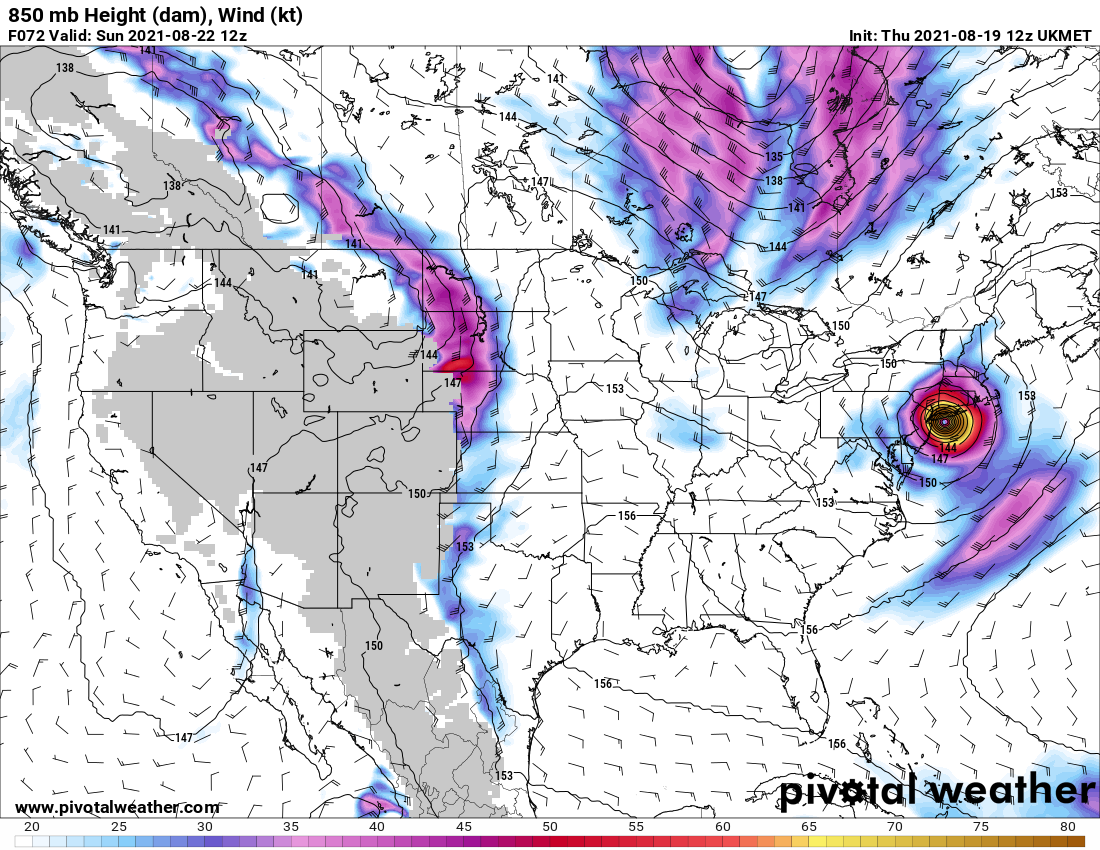
The outflow with Ida is textbook. Won’t be long before it’s upgraded to hurricane status if not already there.
-
I remember seeing an interesting program on tv a couple of years back on global warming. As the earth continues to warm there will come a point where too much fresh water from the melting northern polar cap will mix into the Atlantic thus shutting down the currents and triggering an ice age in the northern half of North America that could last for hundreds of years. So you’re half right. Different cause but in the end the same result.
-
That’s the reason why I despise the summer and relish the cold and snow of winter. Thus my avatar and name.
-
Feb 18-19 long duration manageable snow and ice event
Yanksfan replied to wdrag's topic in New York City Metro
Whether it’s wishcasting or not the radar is exploding down south. I would not be surprised to see a northward shift tomorrow. -
Feb 18-19 long duration manageable snow and ice event
Yanksfan replied to wdrag's topic in New York City Metro
1010 Wins calling for a general 6-10 across the area. The Met mentioned there will be a mix occurring in locations by Friday morning but that is subject to change. -
Don’t look at the GFS thermals. With that track it’s a big snowstorm for all taken verbatim of course.
-
GFS ensembles show 1.5 qpf area wide. Quite impressive for a storm still 5 days away.
- 2,426 replies
-
- 1
-

-
- heavy snow
- ice pellets
- (and 3 more)
-
It’s in the New England forum. It shows 8-12 area wide.
- 2,426 replies
-
- 1
-
-
- heavy snow
- ice pellets
- (and 3 more)
-
It will be interesting to see if the storm slows down/retrogrades in future runs. More often than not it doesn’t pan out.
- 2,426 replies
-
- 1
-
-
- heavy snow
- ice pellets
- (and 3 more)
-
What I meant to say was this could be another below normal snowfall season. Let’s hope things will pick up once we get shorter wave spacing later in the season.
-
I know it’s only late January but this is shaping up to being another snowless winter. This would make it 3 years in a row. Flashback of the 1980’s.
-
We just have to face the facts that in all likelihood this will be the 3rd consecutive winter where the PAC refuses to cooperate despite the overall pattern as a whole reshuffles each ensuing winter. This winter season would hurt the most with a -NAO and we still can’t cash in. Just mind boggling.
-
December 16-17, 2020 Storm Observations and Nowcast
Yanksfan replied to wdrag's topic in New York City Metro
Storm total for me is 8”. It’s not the 12+ I was expecting, but a good storm nonetheless. -
Which seemed to be a slam dunk blizzard yesterday, everybody is freaking out with the sudden NW trends of the models today. I for one didn’t see that coming, but the Euro stopped my worries. Either the models will stand pat from here on out or what I think will happen is a correction back SE.
-
Can anyone confirm this???
-
It looks like it’s south and east to me. Hard to tell with the 24 hr panels.
-
I’d rather not have the wind aspect of the storm materialize. It cuts down on snow growth potential.
- 3,762 replies
-
- 1
-
-
- heavy snow
- heavy rain
- (and 3 more)
-
Ukie is concerning to me cause the Euro tends to follow suit. I guess we’ll see in a bit.
- 3,762 replies
-
- 1
-
-
- heavy snow
- heavy rain
- (and 3 more)
-
This is 12z model madness at its finest. 3 model runs, 3 different solutions. Ok Euro what do you have to say?
-
The GFS as of late has been doing too much waffling for my liking, while the EURO has been holding steadfast with a hugger solution. I’m not buying the EURO either. My gut tells me in the end there will be a compromise between the two models. Something similar what the EPS depicts where the low exits off Delmarva/ Cape May followed by a motion ENE.
-
I am. Thus far we have 4 named storms on June 25th. We got a legit shot of rivaling the 2005 hyper season of 28 storms.