

Tullioz
-
Posts
2,420 -
Joined
-
Last visited
Content Type
Profiles
Blogs
Forums
American Weather
Media Demo
Store
Gallery
Everything posted by Tullioz
-
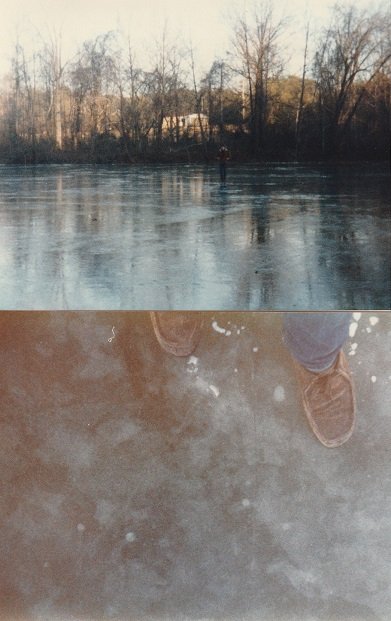
Looking back at my records the low on the 24th came at 11:45pm, so the low for the 24th and the 25th occurred within 8 hours of each other during the same overnight period. I recorded a low of -1 on the 24th (PM), -4 on the 25th (AM), and +2 on the 26th. We had a nice icing event on the 27th with a low of 18 and a high of 29, then there was another cold front that went through on the 29th that resulted in a low of +6 on the 30th and a high of 23. The following morning (31st) the low was +4. Christmas 1983 is in my top 10 weather events I have experienced. The pictures below are of the Smith River in Eden taken on January 1, 1984 where the Ice was between 7 and 9 inches thick and safe enough to walk across.
-
The coldest Christmas in my lifetime was 1983 in Eden, NC. A cold front moved through on Christmas Eve that dropped the temperature from 34 degrees at midnight to 15 by noon; by sunset the temperature had fallen to +4. The low on Christmas morning was -4 and the high only reached 14 with bright sunshine.
-
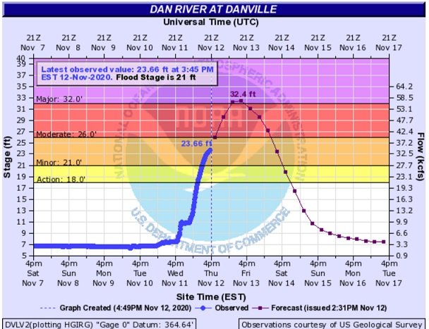
Here's a link to a good site for rainfall estimates that allows you to zoom in to street level. https://www.iweathernet.com/total-rainfall-map-24-hours-to-72-hours It shows 3.96" for my location from this most recent event and I measured 4.07", so it can be used to give a pretty good estimate as to how much rain has fallen. Looking at the rainfall estimates at the link I provided, much of the Dan River Basin in Stokes and Patrick Counties received between 4 and 7 inches of rain. As a result, the Dan River is projected to reach 32.4 feet tomorrow morning in Danville, VA which will become the highest crest ever recorded in Danville if that occurs.
-
Had a wind gust at my location just NW of Eden of 57mph at 6:10pm as a line of storms moved through.
-
I suppose it could be hail then. It was textbook graupel up this way. I also measured a 39 mph wind gust around the same time the shower was passing through.
-
It's graupel. We had a shower pass through Eden about an hour ago producing the same.
-
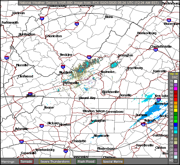
We're having a nice little event here along the NC/VA border. Special Weather Statement National Weather Service BLACKSBURG VA 244 AM EST Sat Feb 29 2020 NCZ001>005-019-VAZ015-016-032-043-290845- Stokes-Surry-Rockingham-Ashe-Wilkes-Alleghany-Henry-Grayson-Patrick- Carroll- 244 AM EST Sat Feb 29 2020 ...A BAND OF HEAVY SNOW WILL AFFECT LOCATIONS NEAR THE BORDER OF VIRGINIA AND NORTH CAROLINA... At 241 AM EST, a band of heavy snow extended from near Nella through Cana to near Horse Pasture. Movement was east at 40 mph. Locations impacted include... Eden... Mount Airy... Flat Rock... Mayodan... Sparta... Jefferson... and Dobson. Expect a rapid accumulation of up to an inch of snow along with visibility near zero at times. Roads will quickly become slippery and make driving hazardous.
-
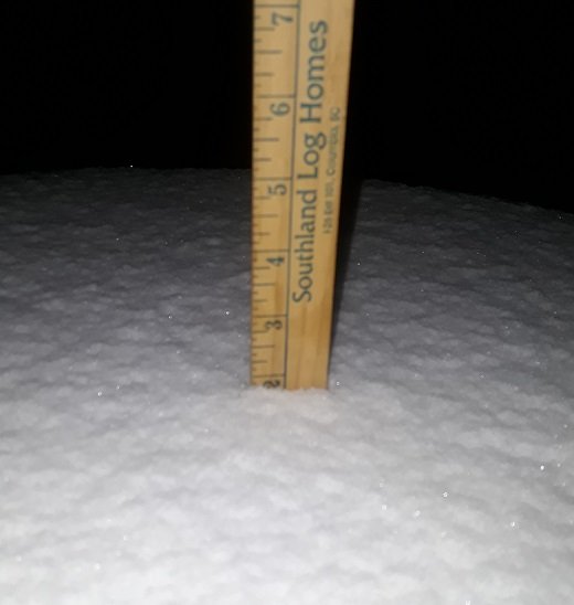
I ended up with around 2" at my location in Eden. It wasn't until a couple hours after the snow had tapered off before I could get a final measurement, so some compacting and melting took place, it may have been slightly higher. I'm currently watching an area of snow that has developed in East of Roanoke over the past hour that is drifting to the south. Several of the models have been showing some additional accumulations for the northern Piedmont from this feature, so it will be interesting to see if that will be the case.
-
It's only a novelty at this point, but many of the models are continuing to show an area of light snow developing in Virginia and dropping into the northern Piedmont of NC before 7am. Accumulations look to be light, an inch or less on most of the models, but it's an interesting feature never the less. I have noticed the radar is just now starting to show returns blossoming between Roanoke and Lynchburg so this may be the beginning stages of what the models are showing. I'm not sure if I'm going to be able to stay awake long enough to see how this plays out though.
-
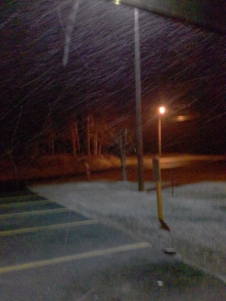
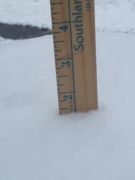
I'm closing in on 1 1/2" in Eden. I'm not sure if I'll make it to two or not with the lighter returns on the radar to the west. The snow rates have become noticeably lighter over the past 30 minutes and the temperature has went back above freezing to 32.4.
-
Starting to see a slushy accumulation on the road in front of my house. HRRR looks encouraging, but looking at radar things will probably start winding down soon in my area, at least the heavier rates of snow anyway.
-
Seeing some pretty good snow rates at this time. The temperature has just dropped below freezing. Currently 31.8 with a dew point of 30.9.

-
It's been just over an hour since the snow started here at my location just NW of Eden and I'm just now starting to see some accumulation in the grass with the temperature just above freezing at 32.7. The dew point has come up to 30.3 from the low 20's this morning.
-
Starting to see the first flakes here in Eden. Very light at the moment. 39.2/25.1
-
It's a long shot for sure and the area that would be affected extremely small geographically, but it could very well be the highlight of this event for some if it does in fact materialize with gusty winds and the higher ratios at the time it moves through. The latest run of the Canadian has a little over an inch of snow falling in the Greensboro area between 1am and 7am.
-
I know it's not much, but for those in the Piedmont of NC a few of the models (GFS, Canadian, UKMET) have been showing a narrow band of light snow moving through from north to south between 1am and 6am Friday morning. This has been showing up for the past few runs and depending on the model looks like it might have the potential to bring an additional 1/2 to 1 inch of snow for those lucky enough to find themselves under it if it were to actually develop. It shows up nicely on the latest run of the RGEM
-
Down to 33.1 and overcast with a dew point of 27.0.
-
37.6/27.2 Mainly Clear 2 miles NW of Eden, NC
-

12/13 - Stop Collaborate and Listen Event
Tullioz replied to rowjimmy73's topic in Southeastern States
31.1/28.2 with light rain/freezing rain and a light glaze on elevated surfaces. The temperature went from 27.3 to 32.9 between 9:45 and 11pm before falling below freezing again shortly after the rain began to fall. -
12/13 - Stop Collaborate and Listen Event
Tullioz replied to rowjimmy73's topic in Southeastern States
You're definitely in a warm spot compared to many areas around you. Looking at Wunderground I can see a couple of stations around Winston Salem/Greensboro that are sitting at 32 degrees or slightly below. -
12/13 - Stop Collaborate and Listen Event
Tullioz replied to rowjimmy73's topic in Southeastern States
27.4/22.1 with high thin clouds filtering the moon. Shiloh Airport (KSIF) in Rockingham County is already down to 26. -
12/13 - Stop Collaborate and Listen Event
Tullioz replied to rowjimmy73's topic in Southeastern States
I'm hoping the RGEM doesn't verify, but it may have a better handle on the temperatures. Just since my last post less than 30 minutes ago the temp has dropped from 38.7 to 35.8. The NWS has the low in my area tonight falling to 32 which is going to bust on the high side as it appears at this time. If the temperatures manage to fall into the mid 20's by the time the precipitation begins, it will likely take them a little longer to rise above freezing than what is currently expected. -
12/13 - Stop Collaborate and Listen Event
Tullioz replied to rowjimmy73's topic in Southeastern States
Looks like this will be a marginal but short lived event here along the NC/VA border. The temperature at my location has already dropped three degrees from the afternoon high of 42. Currently sitting at 38.7 with a dew point of 21 with mainly clear skies. -
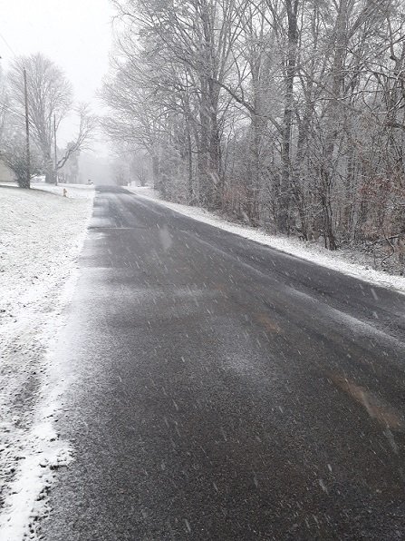
The band of precipitation moving through Rockingham County at this time is producing a mixture of light snow and sleet just northwest of Eden. Current temperature 35.1.
-
Those images are from Typhoon Haiyan.


