Tullioz
-
Posts
2,469 -
Joined
-
Last visited
Content Type
Profiles
Blogs
Forums
American Weather
Media Demo
Store
Gallery
Everything posted by Tullioz
-
I agree, this should be a good run.
-
One of the worst ice storms I ever experienced occurred February 27, 2003. I had around 1" of ice accumulation from freezing rain at my location; some other parts of Rockingham County had even more. High temperatures were in the low to mid-60s in the days leading up to the storm, and the lowest temperature I recorded on the 27th was 28.4.
-
Higher SSTs may be more of an asset than a liability when it comes to winter storms along the east coast. Climate Change and Extreme Snow in the U.S. Conditions that influence the severity of eastern U.S. snowstorms include warmer-than-average ocean surface temperatures in the Atlantic. These can lead to exceptionally high amounts of moisture flowing into a storm and contribute to greater intensification of the storm. Unusually high ocean surface temperatures in the Atlantic were a contributing factor to the February 5–6, 2010, snowstorm dubbed “snowmaggedon” that hit Washington, DC, with 17.8 inches of snow at Reagan National Airport—the fourth highest total storm amount for the city at the time. Also, some recent research has shown that increasing surface temperatures and reductions in Arctic sea ice may produce atmospheric circulation patterns that are favorable for winter storm development in the eastern United States. In addition, studies have shown that natural variability associated with the presence of El Niño conditions has a strong influence on the incidence of severe snowstorms in the eastern United States. Based on an analysis of the top 100 snowstorms in six regions east of the Rocky Mountains, scientists found that severe snowstorms are approximately twice as likely to occur in the Northeast and Southeast regions during years when a moderate to strong El Niño is present as compared to years when neutral conditions exist.
-
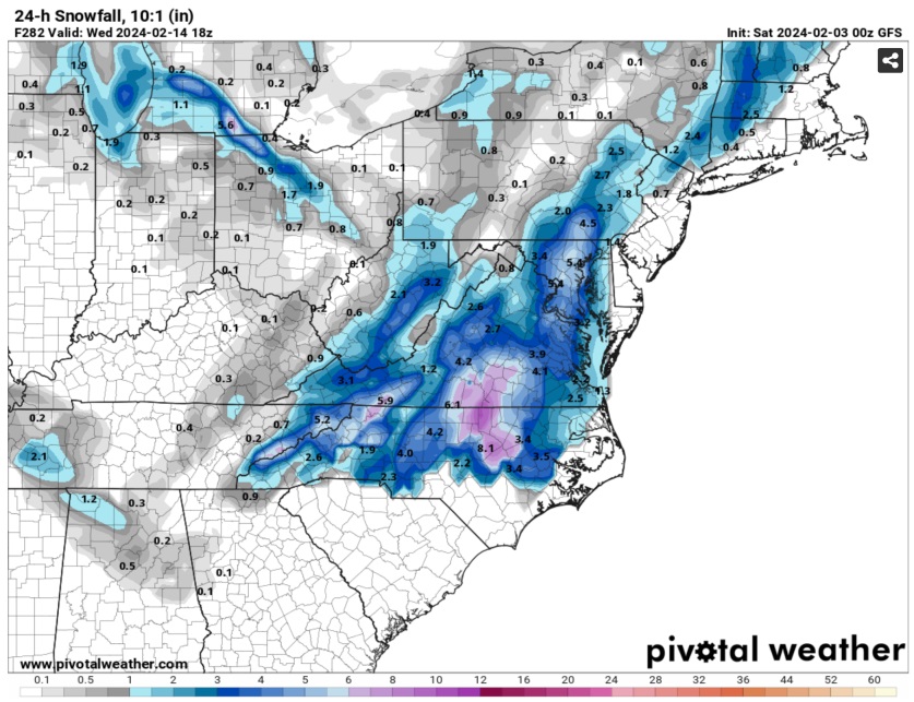
The 0z GFS is showing some love for much of NC on Valentine's Day.
-
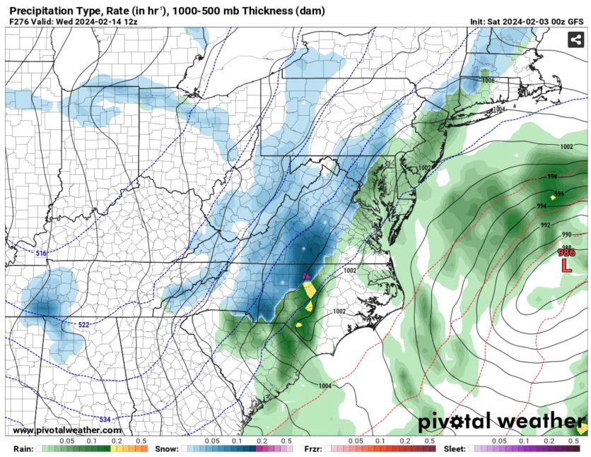
18z GFS.
-
Looks nice.
-
DT isn't always consistant, so I'm not surprised that he has conflicting definitions of what he considers to be the Mid-Atlantic. In the Facebook post I linked to he defines it this way: "So to answer the question directly when we say that term MIDDLE ATLANTIC REGION wxrsk is referring to the northern third of North Carolina ...all of Virginia - except maybe the Southeast corner-- the eastern half OF West Virginia... All of Maryland & Delaware ...all of New Jersey and most of Pennsylvania ... the southern third of New York State... NYC & Long Island."
-
This is correct. DT considers the northern 1/3 of NC as being part of the Mid-Atlantic. WHAT DOES WXRISK MEAN WHEN THEY SAY "MIDDLE ATLANTIC REGION"? The WPC includes all of NC.
-
Currently 26.1/6.9 The high today at my location was 27.5 at 2:05pm after a morning low of 18.3. Today had the coldest afternoon high at my location since December 24, 2022, when the afternoon temperature reached 25.9.
-

Southeast Sanitarium - Winter 23/24 Edition
Tullioz replied to eyewall's topic in Southeastern States
A reminder for those in NC who live outside of the mountains.
-
Dropped down to 9.5 at 7:40 this morning. Current temperature is 22.1
-
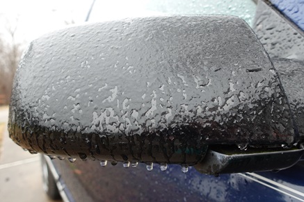
Currently 31.2/30.9 with light freezing rain just northwest of Eden in Rockingham County. There's a glaze on elevated surfaces, but roads are fine.
-
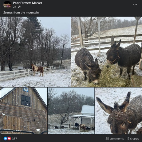
Here's a post from Poor Farmers Market in nearby Meadows of Dan from a couple of hours ago. https://www.facebook.com/poorfarmersmarket/posts/pfbid0AU52HDgq1vTjURNSmdQJctWW9FLTJrWq1XvLxUL9vHsw87spy2xrmb9bKqbRMMzhl
-
Periods of light sleet that occasionally mix with snow when heavier radar returns are overhead have been falling at my location just northwest of Eden for the past hour or so. Currently 32.9/25.5
-
Southeast Sanitarium - Winter 23/24 Edition
Tullioz replied to eyewall's topic in Southeastern States
The models are showing a more favorable pattern beginning next week and continuing into February, so things seem to be on track for now. If nothing materializes by the end of this month, only then will I start to consider that this winter may be in trouble. -
Southeast Sanitarium - Winter 23/24 Edition
Tullioz replied to eyewall's topic in Southeastern States
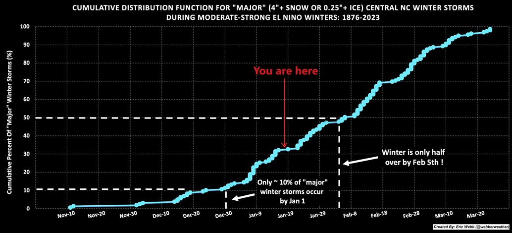
I'm not sure what all of the negativity is about, especially since it's only January 11th. As of now, things are going pretty much as expected for an El Nino winter, with most being back-loaded when it comes to cold and snow. Two of the biggest winters for snow in my part of NC, 1965–66 and 1986–87 (both El Nino winters), each had snowless Decembers, and the first snows in those winters didn't occur until the middle of January. Despite having no snow until mid-January, the winter of 1965–66 had 37.4" for the season, and 1986–87 ended up with 33.5". Both of those winters also had at least one 12-inch snowstorm. On January 25–27, 1966, 13" of snow fell, and again, a couple of days later, another 10" fell on the 29th and 30th. In 1987, 14" fell on January 22nd and 23rd, and again a couple of days later, on January 25th and 26th, another 6" fell. While I'm not expecting a repeat of either of those winters, they, along with other El Nino winters of the past, make me very optimistic that this winter will end up being a decent one once all is said and done. -
The 12z Euro is getting close to being something.
-
The ICON and Canadian are trending in the right direction for early next week.
.gif.5e12472df9dd3a56521a599ba7810e6e.gif)
-
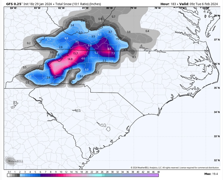
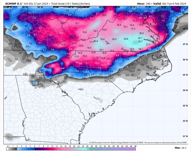
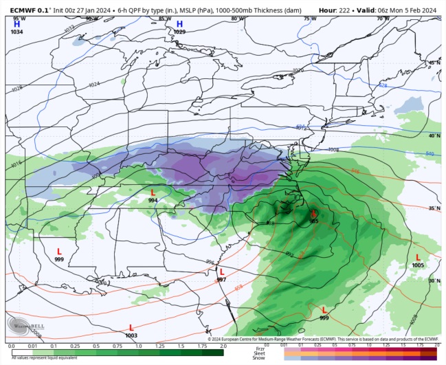
0Z Euro came in even lower. This is going to be an interesting system to track over the next several days.
-
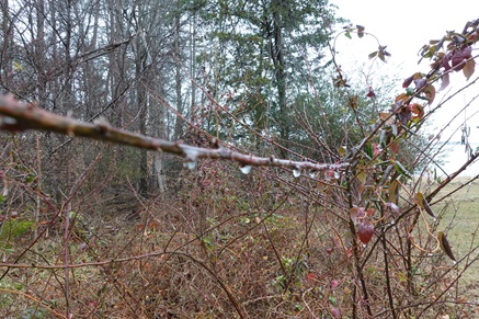
Precipitation never went over to all snow, but there was enough mixed in to leave a little slush on my trash can lid.

-
Rain snow mix 36.1/35.8
-
14.0 degrees this morning at my location, which was the coldest temperature I have recorded in 2023. The coldest temperature prior to this morning was 19.8 on February 4th.
-
BWI: 28.6" DCA: 24.4" IAD: 27.6" RIC: 14.7" Tiebreaker: SBY: 11.9"
-
Had a morning low of 20.8 in my backyard just NW of Eden. Shiloh Airport (KSIF) in Rockingham County also recorded a low of 21.
-
Sleet snow mix at my location just west of Eden with a nice coating so far. The temperature is a bit colder than I expected it to be this morning. Currently 31.1/ 30.3