

BombsAway1288
-
Posts
1,380 -
Joined
-
Last visited
Content Type
Profiles
Blogs
Forums
American Weather
Media Demo
Store
Gallery
Posts posted by BombsAway1288
-
-
1 hour ago, qg_omega said:
Best shot of snow is Friday night into Saturday morning for the coast. Monday is a rain storm. Basically I like the exact opposite of what you posted in terms of snow
Shocker!
-
 2
2
-
-
1 hour ago, CoastalWx said:
Sell GEFS
Really? Is that because they are just not as good as the EPS or not good at all? I would think that any ensembles would be the best approach but then again, every situation is different
-
3 minutes ago, 40/70 Benchmark said:
Its just never wise to do a 180 in one shift..
And jump to really high numbers, like many others have said on here
-
 1
1
-
-
5 minutes ago, NorEastermass128 said:
I can see that, esp if it ticks N in the last hour. Lowest SSTs of the year are a benefit though.
Let's just keep hoping that the Saturday event keeps trending more amped.
As others have said, the more amped Sat is, the flatter the Sunday night/Monday event is.
Gonna be a super tight window to max out on both events either way. I'll be happy with just one of them delivering 8"+
-
1 minute ago, wxsniss said:
18z RGEM did run... it's a monster hit for Mar 2.
It's basically Jimmy's forecast map.
Wouldn't that be something! I'll wait until verification to believe it though
-
1 hour ago, ORH_wxman said:
Looks like the 18z RGEM never ran....so we lose that piece of guidance for this cycle.
Looks like a Met in NYC got it and it seems like good news
24 minutes ago, purduewx80 said:18Z RGEM also more amped; 994 over the Benchmark at 18Z Saturday. 3mb deeper than the 12Z run, closed 700 low is also deeper. Hard to see for sure on the b&w maps but it looks wetter from NYC up to BOS.
-
1 minute ago, SnoSki14 said:
Which is why these late winter fluff events are like stocking stuffers.
In March it's either go big or go home.
Although preferred, I'll happily take my 4.5" from events like last night in a winter like this one. Who cares if a lot of it melts the next day. The streets aren't going to stay snowpacked for days even with a biggie this time of year. It's not Quebec City here
-
47 minutes ago, SnowGoose69 said:
Just wait til the Isles light the Leafs and Tavares up 6-2 tonight
Should be a warm welcome back for him
")
-
13 minutes ago, weathafella said:
And we’re inside 4 days on the whole deal.
What's your total on the season, Jerry? Including whatever you got for the November event.
Thanks!
-
1 hour ago, ORH_wxman said:
Wasn't 3.4 their 7am ob? How would they end up with a final of 3.4 ?
They were under good echoes for at least another couple hours with 1 mile vis SN- and even picked up a few hundreths in the can. With this blower powder, that easily could've been another half to 3 quarters of an inch.
It's BS. I measured 4.1 at 8am and it was still snowing decently then. I walk to work at Logan everyday. There should be no difference.
They probably went out to measure at 1pm after 4 hours of sun and measured 2.1 or something like that. Realized they couldn't send a report that was smaller from earlier and just left it as is from 7am. Just a theory
-
1 hour ago, sbos_wx said:
Logan pulled off at least 4" in reality. Of course we have no idea whether or not this will be official.
I bet you they come in with a 3.9" final, especially if the measurement wasn't taken until 1pm this afternoon.
-
2 minutes ago, ORH_wxman said:
Yeah this is better than 00z (and way better than 06z)....but not there yet. Pretty good thump though for interior (coast gets some too but faster change there)
Probably the best outcome we could expect from the 12z Euro. It's not going to make big changes unless it's not seeing something the others are not. The fact that it goes over the Cape now and is the most NW of all the guidance keeps me hopeful, for now.
Now on to the EPS
-
10 minutes ago, Damage In Tolland said:
Oh boy oh boy oh boy. WSW’s up tomorrow morning most of SNE
Didn't you learn from last night with the absolutes?
Unless you're just joking around...
-
3 minutes ago, ORH_wxman said:
Ukjie is pretty nice for SNE on Monday I would think absent any other data
 1 minute ago, SnowGoose69 said:
And the fact the Saturday storm is making a comeback should force the next event more south and prevent anything like the Op Euro has been showing
Well that's about as good a news we can get from the 12z runs so far.
Whatever happens, this should be fun tracking for the next 4 days with Sat. in-between
-
1
-
-
Just now, weathafella said:
I thought the 0.8 was ok. After that initial band things quieted until the wee hours.
I guess. I had a bit more a bit earlier than midnight but the difference was really negligible.
Hopefully Logan pulled off at least another 0.6" between 7am-9am when the accumulating snow really shut off around here
-
3 minutes ago, Ginx snewx said:
What a weenie GFS run, here comes the Wxniss storm
We really need the Euro to at least trend SE a bit. Like to see what the UK has considering the Euro usually follows suit in a way.
Although, as one other poster pointed out before, if the models can't nail down the location of Saturday's storm now, how are they going to get Monday's storm correct.
EPS trends will be important too this afternoon, although not do or die for reasons explained before
-
I would bet we had at least 12-15:1 or maybe even more here on the coast. It was super fluffy and accumulating the best it has all year
-
3 minutes ago, weathafella said:
BOS 3.4 as of 7am. They may end up with 4+ as a final.
Well I have 4.1 as a final so it's possible but I doubt they I wasn't buying the 0.8 at midnight. Maybe the old guy is back
-
11 minutes ago, CoastalWx said:
Euro still pretty amped. A little tamer than 12z though. Complete crush job for VT-NH-ME. Central and northern parts of those states.
So it's pretty much everything vs. the Euro, right?
If so, a compromise of tracks would fit the season pattern of tracking over the Canal
-
Interesting stuff with these 2 being so far apart even at this lead time but what else could we expect for Winter 2018-2019. They'll probably stay this way for the next 3 days.
Would still love to see the UK come in with a GFS solution tonight though
-
Just now, CoastalWx said:
Wow looks like almost like an inch at home. Great flakes.
GF says yes to that in South Weymouth
-
11 minutes ago, ORH_wxman said:
Nice band from Windham County CT to BOS
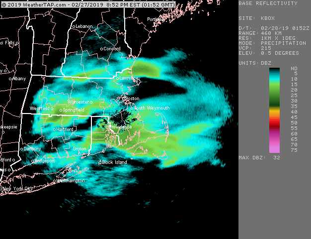
Best growth of the year here. Big fat beautiful flakes
-
1 minute ago, Spanks45 said:
I wasn't expecting much, a coating to an inch was about it...but at this point we might not see anything besides a few stray flurries, nws still has an advisory for 1-2 inches. Last week were were expecting 1-3 and woke up with 0.25" of sleet...
Yikes. Yeah, Upton can't seem to get anything right these days.
I'm still waiting for my 24"-36" from Jan 15' they were still forecasting hours after storm started!
-
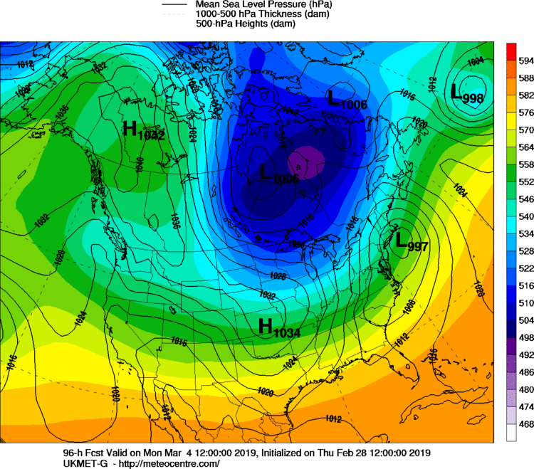
3 hours ago, David-LI said:
Hows the 18z euro looking?
For what?
It only goes out to 90 hrs-
1
-
March Disco
in New England
Posted
Thanks for the answer. I'm just gonna enjoy whatever Saturday brings us for now and worry about Sunday/Monday after even though you're probably right as that has been the track of the season to take, right over the Canal/Cape