

ILSNOW
-
Posts
1,512 -
Joined
-
Last visited
Content Type
Profiles
Blogs
Forums
American Weather
Media Demo
Store
Gallery
Posts posted by ILSNOW
-
-
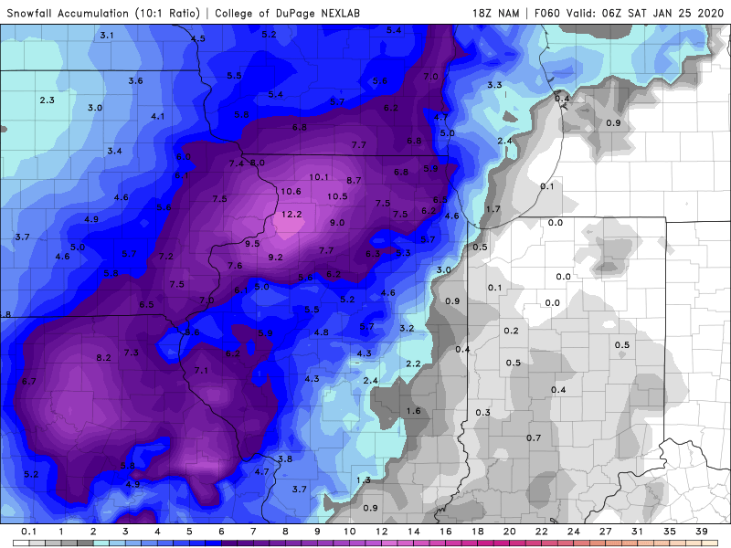
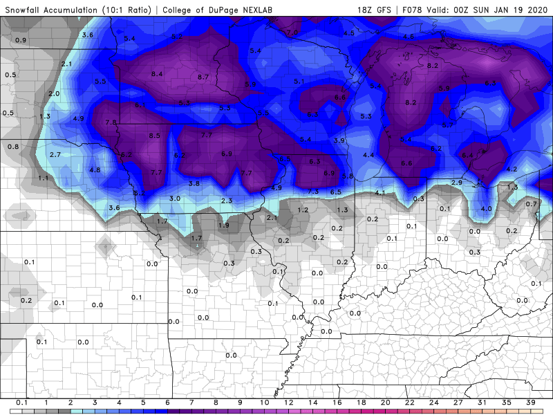
18z NAM Rainer thru 60 hrs
-
 2
2
-
-
24 minutes ago, A-L-E-K said:
euro following consensus of a DAB+ followed by a rainer
#DUD


-
 1
1
-
-
47 minutes ago, A-L-E-K said:
i work with what i'm given
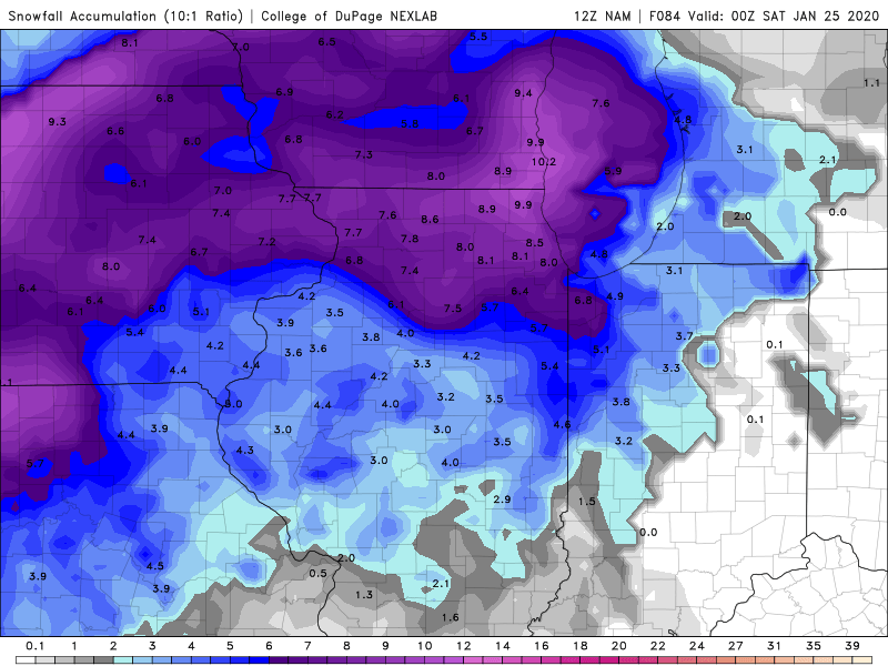
12z NAM response to ALEK
-
1
-
-
-
8 minutes ago, A-L-E-K said:
I'm trying to troll here, ricky
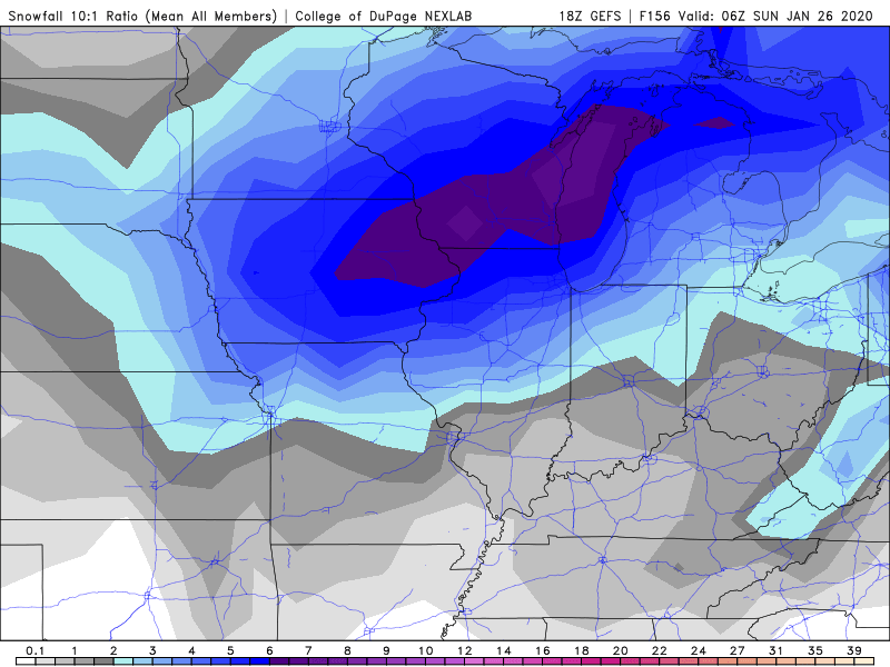
you asked for it 18z GEFS for winter storm #dud


-
3
-
-
That’s 0.7 inches of flurries

-
1
-
-
41 minutes ago, A-L-E-K said:
just give up, this one is obv a dud
12z Euro take on ALEK's dud


-
1
-
-
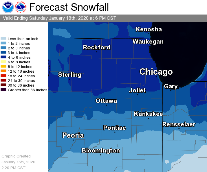
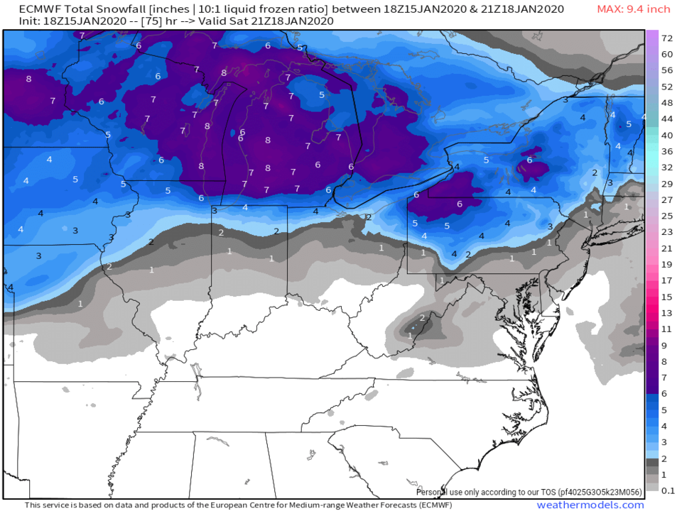
typical of this winter Missouri in the 6-10 range and chicagoland in the 2-4 range. What an awful winter!!!

-
1
-
 1
1
-
-
Question the control 18z gfs is a Rainer so why does the gefs show the following
-
1
-
-
In this crappy winter the next chance of snow via 12z EURO at 168 hrs (fantasy land).
We need Thundersnow to start a topic.

-
2
-
-
Just now, Hoosier said:
Update is still there for me.
Could've upgraded to a warning imo, at least for the ice around/south of I-80. Not necessarily a clear cut thing but there should be some quarter inch amounts and the wind will add to the impact. The negative factor for upgrading is that it is an overnight icing event and if a tree falls in the forest...
The update is gone for me. Have much bigger flakes now prolly transitioning to a mix
-
LOT just put out nice update. Expecting 5-6 north of i88 before changeover
there was an 8:56 update that is now gone
-
2 minutes ago, tuanis said:
Closing in on 4”, blowing around pretty good, solid flake size. Forgot what this looks like.
Same here been a long time
-
12z RGEM
i know models don’t matter at this point but I thought that RGEM would have backed off somewhat by now

-
17 minutes ago, Thundersnow12 said:
18z Nest almost looks like the 12z RGEM. 6.6" ORD on the Nest with some impressive backside snows too
Updated LOT
-
 1
1
-
-
5 minutes ago, A-L-E-K said:
NAM improved quite a bit locally, gonna need the ICON/GFS to verify for my call, needless to say feeling confident
Would imagine Winter Weather advisories are Coming for the LOT area
-
Euro


-
1
-
-
12 minutes ago, A-L-E-K said:
we're riding the canadian now
Your 2.5 could very well be a bust on the high side
-
6 minutes ago, A-L-E-K said:
we're riding the canadian now
Until the euro comes out and if we don’t like it we will toss it out as trash
-
0z CMC going a little crazy


-
1
-
-
18z euro
-
1
-
2
-
-
8 minutes ago, Chicago Storm said:
wut?
To low for Chicagoland???
-
1
-
2
-
1
-
-
-
12z euro


-
1
-
2
-


January 22nd-25th Winter Storm Potential
in Lakes/Ohio Valley
Posted