

ILSNOW
-
Posts
1,508 -
Joined
-
Last visited
Content Type
Profiles
Blogs
Forums
American Weather
Media Demo
Store
Gallery
Everything posted by ILSNOW
-
-
-
12z RGEM based off this run the northern suburbs are out!!!! It is possible that the northern suburbs might miss out but throwing in the towel based off of the 84hr NAM is crazy. I believe the system will be entering the west coast overnight and we still have 48 hours of model runs to get thru and you dont want to be in the bullseye now.
-
GEM 12Z GEM 0z
-
-
12z EURO
-
Winter 2020/2021 Short Range Discussion
ILSNOW replied to Chicago Storm's topic in Lakes/Ohio Valley
Ripped for about 45 minutes. Nice to see again I miss the old days when it would snow like this for hours. -
Winter 2020/2021 Short Range Discussion
ILSNOW replied to Chicago Storm's topic in Lakes/Ohio Valley
Moderate snow just started here -
I was looking at the GDSP 198 hour map. And if you want to compare 2 different models you might want to look at them for the same time period.
-
Canadian agrees with that statement.
-
and this beauty 10 days out . Sad having to post 10 day snow maps in mid Jan.
-
Winter 2020/2021 Short Range Discussion
ILSNOW replied to Chicago Storm's topic in Lakes/Ohio Valley
RGEM and this -
Cotton like white substance is starting to mix in here.
-
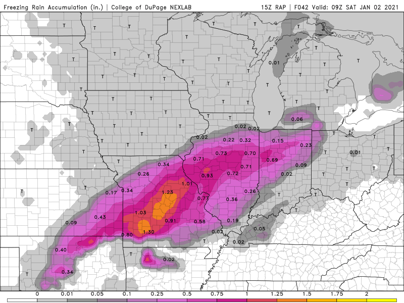
15Z RAP Ice Snow
-
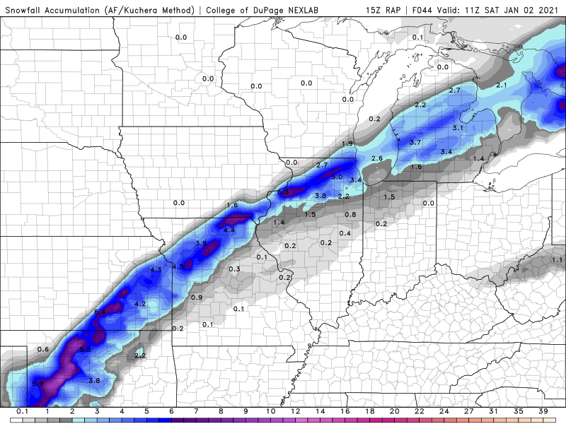
12Z HRRR
-
Chicago NWS Attention then turns quickly to that closed upper circulation to our southwest Thursday evening. Models remain in pretty good agreement in giving the short wave a negative-tilt orientation and pivoting it north-northeastward Thursday night. Precipitation is expected to develop and spread back north into the forecast area especially after midnight, as substantial warm/moist advection produces forced ascent and nudges the baroclinic zone associated with the old cold front to our south back into the area. Sub- freezing surface temperatures, reinforced by cool east-northeast flow from the retreating high to our north, will set the stage for a period of primarily freezing rain and sleet overnight into Friday morning (with some snow possible far north/northwest) as temperatures aloft rise above 0C. This is well-depicted in forecast soundings, which indicate a substantial warm layer centered around 850 mb, where temps warm from roughly +2 to +6 C (warmest south) by 12Z Friday. Surface temps are progged to slowly rise above freezing across the southeast half to two-thirds of the cwa through Friday afternoon as the surface low continues to lift toward the area, with decent model agreement that it eventually tracks somewhere near the southern end of Lake Michigan early Friday evening. With a plume of Gulf moisture allowing for model QPF of 0.25-0.50 inches or more across the area through midday Friday, the concern is that there could be some significant ice accumulation prior to freezing rain changing over to rain when temps warm above freezing, with our northwest counties across north central IL potentially seeing a mix of snow/sleet and freezing rain linger Friday afternoon. With the current track of the surface low, afternoon temps are expected to range from the low-mid 30s around Rockford, to around 40 in our southeast.
-
-
our buddy with and update National Weather Service Chicago/Romeoville, IL 1032 AM CST Mon Dec 28 2020 .UPDATE... 1032 AM CST No big changes to the forecast for tomorrow-tomorrow night`s wintry precip event. In addition to a decision on the Winter Storm Watch for Winnebago, Boone, and Ogle Counties, will be needing a Winter Weather Advisory for a good chunk of the remainder of the CWA, likely including the entire Chicago metro. Will defer these decisions to the full afternoon forecast package issuance. Looking at the 12z suite thus far, noting a tendency for pretty rapid top-down saturation of the initially dry cP air mass in the wake of departing high pressure, so envision a bit earlier onset than in current official forecast. Ingredients discussed in the short term discussion from the overnight shift are certainly there, with their longest duration and impacts generally where the watch is in effect. Forecast soundings indicate that the snow will likely fall at a moderate to even heavy clip along and north of the Kankakee River (shorter duration south of I-80), with strong omega well aligned with the DGZ into the early to mid evening. Onset time of the snow will be just prior to and during the afternoon commute hours, so travel impacts are likely. With the strong LLJ driving strong WAA, eventually a warm nose will surge in aloft during the mid to late evening, changing precip over to sleet and then freezing rain, latest in the far north where snow should hold on a bit longer. Given the accumulating snow, followed by sleet and then up to to 1/10-2/10" ice, hazardous travel can be expected, warranting expected advisory issuance and perhaps upgrade to warning where a watch is in effect. Castro
-
GEM wave 1
-
Long way off and lots can and will change But talk about a dramatic cutoff!!!!
-
A little icy
-
Ride the ICON
-
This says it all 240 hr maps are meaningless but LOL at the Chicago donut whole.
-
Enjoy
-
You want to remember what tracking a potential winter storm is like head over to the nyc forum where they are tracking a potential 15-30 inch storm. Very jealous hoping for a few mood flakes later.


