

ILSNOW
-
Posts
1,508 -
Joined
-
Last visited
Content Type
Profiles
Blogs
Forums
American Weather
Media Demo
Store
Gallery
Everything posted by ILSNOW
-
GFS para (for whatever thats worth) appears to not minor out the snow as quickly. vs GFS
-
Isnt it the Confluence in S Canada/N Lakes/Northeast bouncing around north and south each model run thats causing the issues?
-
SREF Plumes mean at ORD is up to 8.5 with 5 or 6 clunkers and with 8 anywhere from 8.5 to 14.
-
-
They should go Winter Storm Watch chicago north and west for 6-10 inches in the morning. Hopefully RC will trim in.
-
Place to be is S central Iowa!!!!
-
I see the GEM out to 42 hrs
-
is the para any good?
-
Question for the Mets how can the GFS para spit out 1.5 inches of precip for Chicago while the GFS spits out 0.8? Arent they somewhat similar models?
-
and para GFS
-
from KLOT For snow totals, we`re still too far to reasonably push deterministic numbers far and wide, but the likelihood of over 4 inches for much of the area north of I-80 from Monday afternoon - Tuesday morning is fairly high. For 6-8 inches, that potential is there and hence why about one more shift of seeing that we will be ready for a Watch, but just how much of a footprint is still unknown, including northeast Illinois and especially far northwest Indiana. The snow type will be a wetter one, with ratios in the 7:1 to 10:1 possibly all the way through Monday night. Tuesday should see ratios inch slower up under cooling mid-level profiles. With northeast winds gusting to 30 mph Monday night (near 40 mph possible near the lake), this seems like it could be the character of event where wet snow is plastered on signs/stoplights/windows.
-
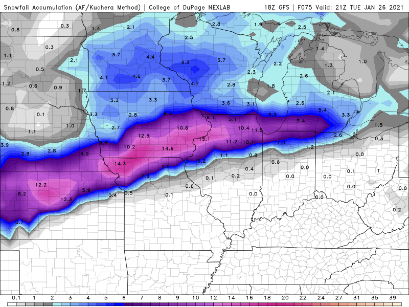
closeup for chicago folks
-
18Z GFS
-
KLOT brief update 325 PM CST Sunday Night through Saturday... A short AFD for now and then will send a more thorough one with the scientific details in a bit. The bottom line is that the message for Monday-Tuesday continues near similar, with some more honing in on details as possible. The potential for heavy snow is increasing for northern Illinois, it`s just how much of the area north of I-80 is favored and the duration of the snow into Tuesday, while the confidence in a mix for the southern CWA has also increased further. This still does not look like a significant ice event due to the character of the system, but at least minor icing is likely. For the area most favored for the heavy snow, at this time no Winter Storm Watch given still 48 hours from the heaviest snow and the uncertainties, but if trends continue, one will likely need to be issued in the next 12-18 hours. MTF
-
-
-
For my area last 4 runs. What a crap model!!! Oz 1.5 6z 1.0 12z 6.4 18z 9.0
-
https://www.spc.noaa.gov/exper/sref/srefplumes/
-
and it is being weighed down by 5 members at 2 inches. Also it has 11 members between 8.5 and 13.5 inches.
-
Even the ICON is coming on board
-
12z RGEM liking ALEK
-
dont forget these are 10:1 ratios
-
YEP yep 12z 0z
-
Nice snow desert for chicagoland on 18z NAM LOL!!!
-
'


