

ILSNOW
-
Posts
1,433 -
Joined
-
Last visited
Content Type
Profiles
Blogs
Forums
American Weather
Media Demo
Store
Gallery
Posts posted by ILSNOW
-
-
Just now, RyanDe680 said:
I spent 20 minutes looking for that - can you post the link from weather.gov?
-
 2
2
-
-
3 minutes ago, wegoweather said:
Plumes trending up to 7.5 at ORD.
and it is being weighed down by 5 members at 2 inches. Also it has 11 members between 8.5 and 13.5 inches.
-
Even the ICON is coming on board
-
 1
1
-
-
12z RGEM liking ALEK

-
2
-
-
Just now, Malacka11 said:
I like the ukie track if we could just bump those totals up
dont forget these are 10:1 ratios
-
1
-
 1
1
-
-
YEP
Just now, hawkeye_wx said:UK well north
yep 12z

0z

-
1
-
-
Nice snow desert for chicagoland on 18z NAM LOL!!!

-
-
-
-
12z RGEM based off this run the northern suburbs are out!!!!
It is possible that the northern suburbs might miss out but throwing in the towel based off of the 84hr NAM is crazy. I believe the system will be entering the west coast overnight and we still have 48 hours of model runs to get thru and you dont want to be in the bullseye now.

-
 1
1
-
-
GEM 12Z

GEM 0z

-
1
-
-
-
12z EURO

-
1
-
-
11 minutes ago, mimillman said:
Buffalo Grove probably ripping right now
Ripped for about 45 minutes. Nice to see again I miss the old days when it would snow like this for hours.
-
1
-
-
Moderate snow just started here
-
7 minutes ago, Spartman said:
12z GDPS:

12z GFS:

I was looking at the GDSP 198 hour map. And if you want to compare 2 different models you might want to look at them for the same time period.
-
30 minutes ago, mimillman said:
GFS says next weekend ain't over
Canadian agrees with that statement.
-
and this beauty 10 days out . Sad having to post 10 day snow maps in mid Jan.

-
 1
1
-
-
RGEM

and this

-
1
-
-
Cotton like white substance is starting to mix in here.
-
1
-
-
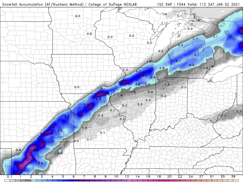
15Z RAP
Ice
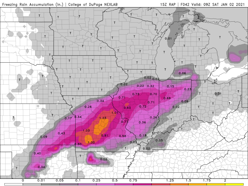
Snow
-
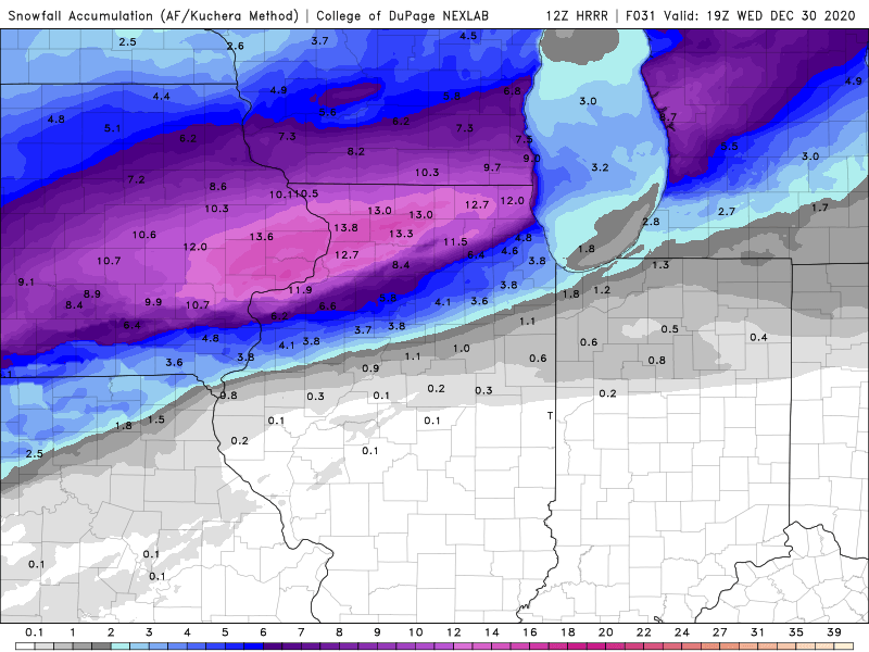
12Z HRRR
-
2
-
-
Chicago NWS
Attention then turns quickly to that closed upper circulation to
our southwest Thursday evening. Models remain in pretty good
agreement in giving the short wave a negative-tilt orientation and
pivoting it north-northeastward Thursday night. Precipitation is
expected to develop and spread back north into the forecast area
especially after midnight, as substantial warm/moist advection
produces forced ascent and nudges the baroclinic zone associated
with the old cold front to our south back into the area. Sub-
freezing surface temperatures, reinforced by cool east-northeast
flow from the retreating high to our north, will set the stage for
a period of primarily freezing rain and sleet overnight into
Friday morning (with some snow possible far north/northwest) as
temperatures aloft rise above 0C. This is well-depicted in
forecast soundings, which indicate a substantial warm layer
centered around 850 mb, where temps warm from roughly +2 to +6 C
(warmest south) by 12Z Friday. Surface temps are progged to slowly
rise above freezing across the southeast half to two-thirds of
the cwa through Friday afternoon as the surface low continues to
lift toward the area, with decent model agreement that it
eventually tracks somewhere near the southern end of Lake Michigan
early Friday evening. With a plume of Gulf moisture allowing for
model QPF of 0.25-0.50 inches or more across the area through
midday Friday, the concern is that there could be some significant
ice accumulation prior to freezing rain changing over to rain
when temps warm above freezing, with our northwest counties across
north central IL potentially seeing a mix of snow/sleet and
freezing rain linger Friday afternoon. With the current track of
the surface low, afternoon temps are expected to range from the
low-mid 30s around Rockford, to around 40 in our southeast.
 '
'


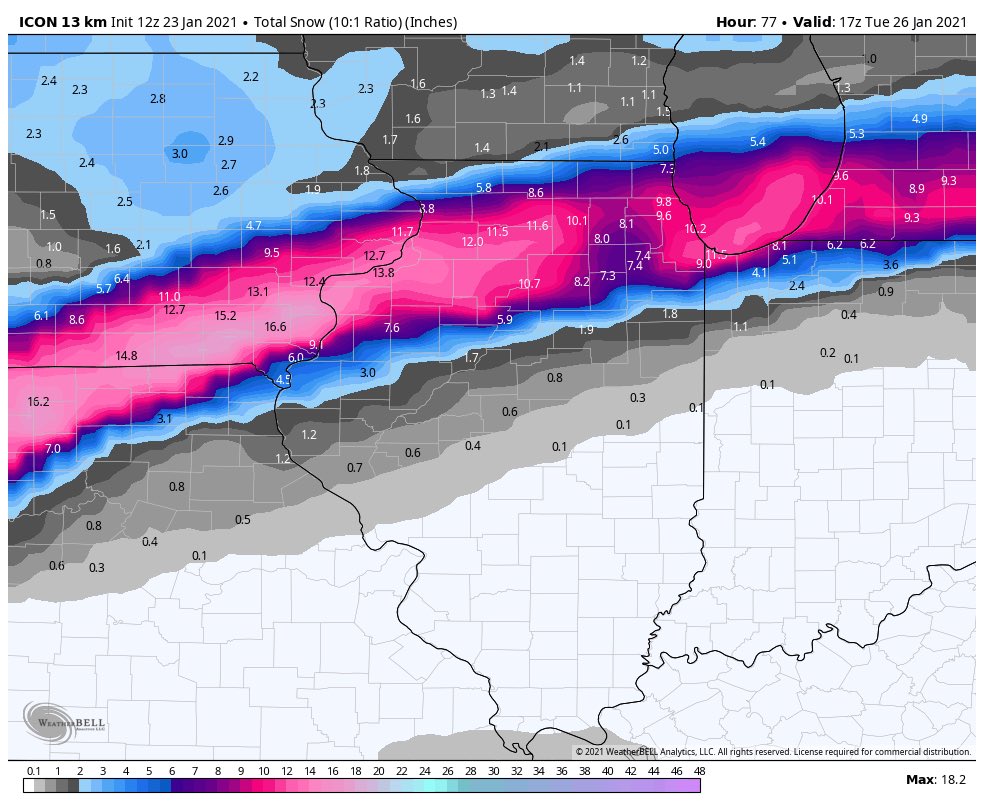
Jan 24-26th Potential Something Part 2
in Lakes/Ohio Valley
Posted
For my area last 4 runs. What a crap model!!!
Oz 1.5
6z 1.0
12z 6.4
18z 9.0