ILSNOW
-
Posts
1,508 -
Joined
-
Last visited
Content Type
Profiles
Blogs
Forums
American Weather
Media Demo
Store
Gallery
Everything posted by ILSNOW
-
models are useless 12Z GEM 12Z GFS
-
12z Euro is very similar
-
Good for you enjoy!!! Looking forward to the polar vortex visiting at the end of the month with bare ground.
-
you r correct my bad !!!!
-
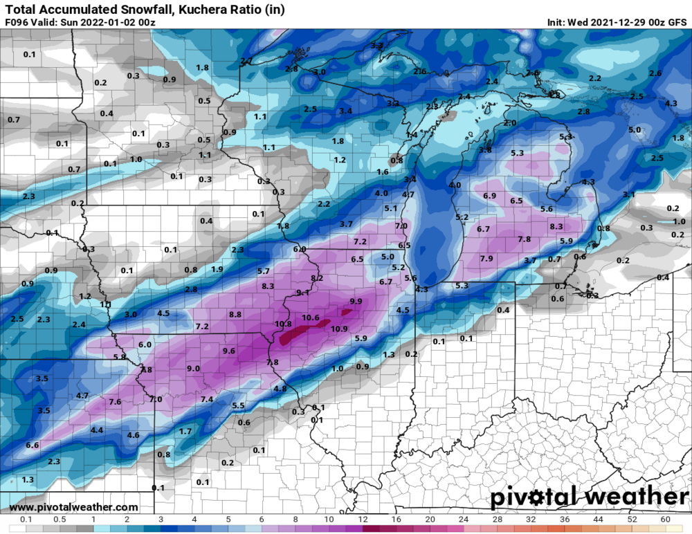
This is the 12z GFS 384 hr snow map (Are you kidding me)
-
Winter 2021-22 Short/Medium Range Discussion
ILSNOW replied to Chicago Storm's topic in Lakes/Ohio Valley
Ricky Next item of note is the potential for a period of robust snow showers/squalls on the Arctic front late tonight-early Wednesday. including into Chicago. We wouldn`t be looking at much in the way of accumulation, though snow could fall heavily for a short period and coat paved surfaces, which would be problematic as temperatures plummet through Wednesday morning behind the front. Finally, have higher confidence in advisory criteria westerly winds (45+ mph gusts) for much of if not the entire area through early Wednesday afternoon. For the full forecast package issuance this afternoon, will be considering a Winter Weather Advisory expansion, as well as likely issuing a Wind Advisory for the remaining counties. Castro -
Hopefully February will be rockin!!!!!
-
yep high and dry for the next 10 days we are heading to mid Jan with 1 snow event for entire season.
-
5 inches here in Buffalo Grove
-
U r under a winter storm warning for a duster!!!!!
-
-
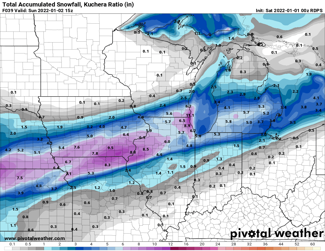
snippets from KLOT Saturday morning, snow appears poised to spread quickly from south to north across much of northern Illinois and far northwestern Indiana and last through the remainder of the day. The steadiest snow looks to remain within a 10-12 hour period from roughly noon Saturday to midnight Sunday, with snow rates of 0.5"/hr prevailing. Heavier snow rates approaching 1"/hr may develop within transient frontogenetical bands as well as along the Illinois shoreline of Lake Michigan where sufficiently cool temperatures will make the marine airmass unstable within a favorable northeasterly wind trajectory. After midnight, snow will taper from west to east except along the Lake Michigan shore where lake enhancement will continue through daybreak Sunday. Snow ratios look to start near 10:1 Saturday afternoon and increase toward 18:1 Saturday night as the low-level temperature profile cools. The highest confidence area for hitting warning-level impacts (e.g. where travel would be discouraged entirely) is actually in Lake County (IL), eastern DuPage County, and all of Cook County where there appears to be an increasing chance that lake-enhanced snow rates of 1"/hr will overlap with blustery northeast winds, leading to low visibility.
-
Hopefully Ricky will stop by
-
total precip
-
look at that cutoff from Arlington Heights to Downtown Chicago ( about 25 miles)
-
-
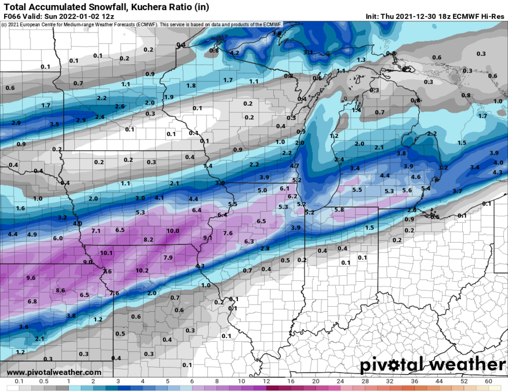
18z Euro

-
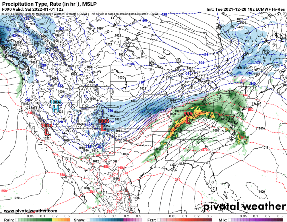
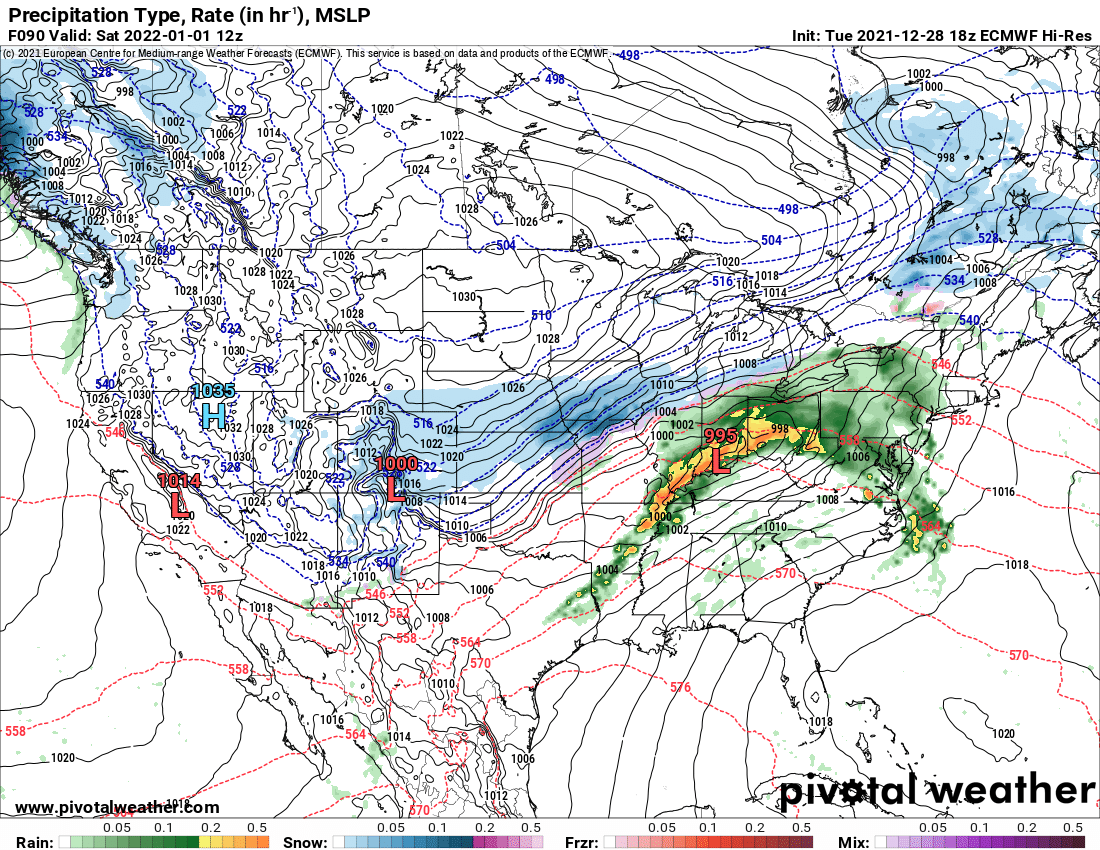
snippets from KLOT An early look at forecast thermal profiles reveals an excellent and deep DGZ with prolific lift, which will encourage fluffy snow ratios of 15:1 or higher. When paired with a strong pressure gradient bolstered by a 1025+ mb high pressure system across the Dakotas, there will be a threat for blustery northeast wind with blowing snow and low visibility within the deformation shield. Interestingly, the 12Z deterministic guidance appears to exhibit excellent agreement showing the track of the low from roughly Tulsa, Oklahoma to Cincinnati, Ohio with the aforementioned band of accumulating snow plastered through the heart of our forecast area. With such a track, cooling 850mb temperatures and northeasterly winds will be more than sufficient for enhancement to snow rates along the Lake Michigan shore with low (if not very low) visibility. Snow would taper overnight into Sunday, with lake effect snow persisting in northwestern Indiana through Sunday afternoon. there does appear to be increasing consistency among all members that the swath of snow will at least touch our forecast area (about 27% of the 51 members drop >6" of snow somewhere in northern Illinois and northwest Indiana). While confidence continues to increase that a winter storm will impact at least part of our area, we continue to urge caution with premature snow forecasts. The message remains that the threat for travel disruptions via air and land on Saturday continues to increase.
-
comparison 6z NAM vs 12z NAM (Just a slight difference) 12Z NAM
-
0z CMC weaker and south
-
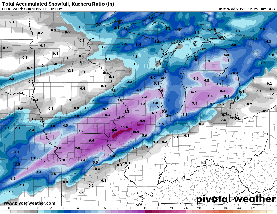
0z GFS
-
18z Euro 90 hours some big changes