ILSNOW
-
Posts
1,508 -
Joined
-
Last visited
Content Type
Profiles
Blogs
Forums
American Weather
Media Demo
Store
Gallery
Everything posted by ILSNOW
-
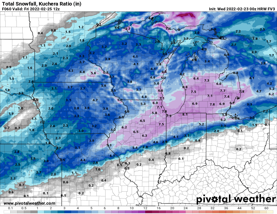
Pre-Christmas (Dec 21-23rd) Winter Storm
ILSNOW replied to Chicago Storm's topic in Lakes/Ohio Valley
Thanks -
Pre-Christmas (Dec 21-23rd) Winter Storm
ILSNOW replied to Chicago Storm's topic in Lakes/Ohio Valley
Chicago can you/are you allowed to post the map? thanks -
Pre-Christmas (Dec 21-23rd) Winter Storm
ILSNOW replied to Chicago Storm's topic in Lakes/Ohio Valley
6z GEFS run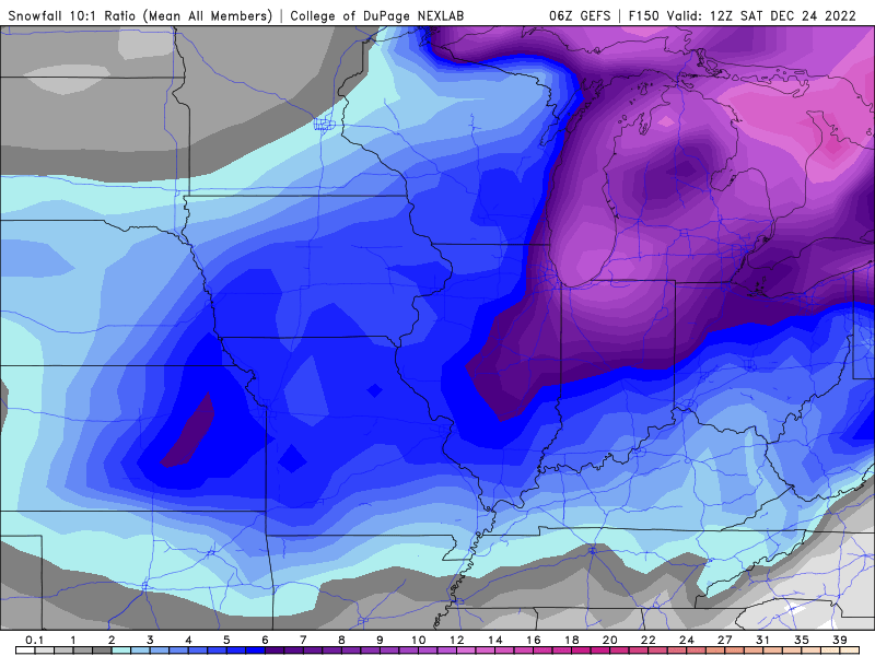
-
Pre-Christmas (Dec 21-23rd) Winter Storm
ILSNOW replied to Chicago Storm's topic in Lakes/Ohio Valley
GEFS has some big hits and some total misses. -
Winter 2022/23 Medium/Long Range Discussion
ILSNOW replied to Chicago Storm's topic in Lakes/Ohio Valley
Would be a Christmas snow to remember !!! -
Winter 2022/23 Medium/Long Range Discussion
ILSNOW replied to Chicago Storm's topic in Lakes/Ohio Valley
10 days out may be our best shot at white christmas -
In Williamstown, New York, which is about 25 miles northeast of Syracuse, 24 inches of snow was measured on Friday morning. In Hamburg, New York, which is about 12 miles south of Buffalo, 22.5 inches of snow was measured at one weather station Friday morning. Snowfall rates of 5 inches per hour were reported in Hamburg. According to AccuWeather Senior Meteorologist Dan Pydynowski, the weather station in Hamburg recorded 2.5 inches in 30 minutes on Friday morning. In Orchard Park, which is where the Buffalo Bills football stadium is located, 18.5 inches of snow was measured Friday morning. Snowfall totals at the weather station located at Buffalo Niagara International Airport, 12.5 inches of snow has fallen.
-
Just your normal 70 inch lake effect snow event
-
First flakes of the season are flying
-
2022 Short/Medium Range Severe Weather Discussion
ILSNOW replied to Chicago Storm's topic in Lakes/Ohio Valley
Chicago NWS .MESOSCALE DISCUSSION... Issued at 1102 AM CDT Mon Jun 13 2022 Concerns continue to focus on the best timing of possible significant severe thunderstorms with heavy rainfall this afternoon into early this evening. A couple of MCV`s, with ongoing convection are present to our west-northwest. The first is located over northeastern IA, with another one farther northwest into MN. Concerns are that the extensive convection over southern MN into northeastern IA in association with these features will mature into one or two east- southeastward forward propagating MCS`s this afternoon into early evening as surface warm front (and the strongly unstable airmass to its south) shifts northward into parts of northern IL and northwestern IN. The airmass within and near the warm sector is already extremely unstable thanks to hot and humid surface conditions (temperatures into the 80s amidst dew points well into the 70s). In fact, MUCAPE was already calculated at nearly 6,000 J/KG on the 12z KILX RAOB, with mid-level lapse rates in excess of 8.5C per km in the EML. The instability gradient is expected to set up right over northern IL and southern WI into Lower Michigan this afternoon, and will essentially offer the pathway for any forward propagating MCS`s this afternoon. However, exactly where any MCS will propagate remains uncertain and will be tied to *when* the system develops. An earlier development over far western Wisconsin would place our area in the crosshairs, while a later development over eastern Wisconsin would favor a path entirely outside our area and in Lower Michigan. At any rate, the MCS will have the potential to produce significant severe winds in excess of 75 mph given the very impressive thermodyamics. Moreover, deep layer shear is expected to be enhanced this afternoon as a 50+ kt enhanced mid- level jet along the southern periphery of the MCVs shifts overhead. Accordingly the threat for damaging hail and tornadoes would exist, as well. And, not to be forgotten, torrential downpours will also accompany these storms given PWATs at or just above 2". It appears the main window of severe threat for the area will be after 2 or 3 pm this afternoon through 7 or 8 pm this evening. KJB -
pretty clear that the 18z NAM is the only model that has a handle on this (joking)
-
X marks the spot
-
Yep the radar does luck awful
-
point n click for Buffalo Grove Thursday Night Snow. Low around 22. East northeast wind 5 to 10 mph becoming north after midnight. Winds could gust as high as 15 mph. Chance of precipitation is 90%. New snow accumulation of 3 to 5 inches possible.
-
FV3 for $100 please
-
FV3 to the rescue

-
was actually a hail storm here
-
12z Euro snowstorm (what a surprise another POS)
-
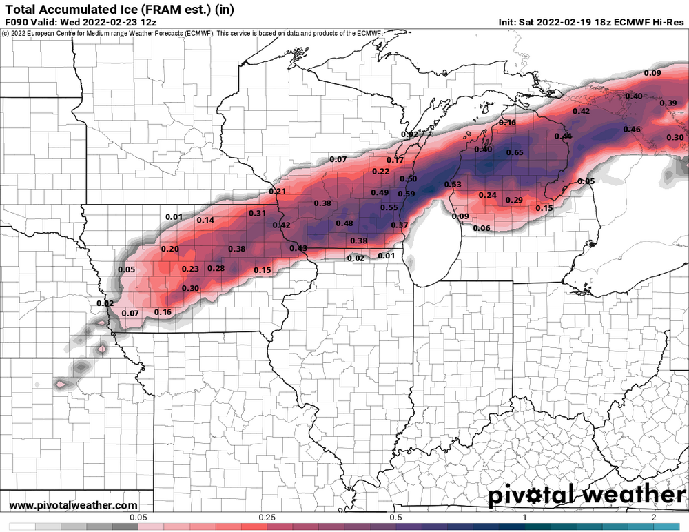
would like to have this as EZ toss as well (dont need ice)
-
Euro ice for Wisconsin
-
Tuesday a rainer and this one a 2-4 incher that will end up being a duster up here
-
When it’s goes south!!!
-
Looks like we finally get our north trend. Enjoy the rain.
-
Top 5 snow event While the cold front will become increasingly removed the eastward moving mid-level trough and moisture, these showers are expected to survive into at least northern Illinois early to mid-evening. Several snow squall ingredients will be in place, chiefly a linear forcing mechanism with sufficient low- level instability nearing 50 J/kg in the well-mixed layer in the lowest 6kft. Brief sharp reductions in visibility (possibly near white-out) and quick accumulations of a half inch to very locally 1 inch in 30 minutes or less are possible across northern Illinois. Timing favors 6-8pm for the Rockford area and 8-10pm for most of the Chicago metro.
-
KLOT Update Through tonight... Heavy snow has expanded across much of the forecast area southeast of a line from Waukegan to Dixon, with very dangerous conditions unfolding for areas south of the Kankakee River into east-central Illinois. Meanwhile, a period of moderate to heavy snow with gusty winds will result in significant travel impacts into the Chicago metro through early evening. It is highly recommended that any unnecessary travel be delayed through at least early evening. The 850-700 hPa F-gen axis across northwest Illinois that was noted in an earlier AFD update is apparently playing a major role in shifting the heavier snow back north after guidance continued its southward trend prior to 12Z. The top-down saturation of this band likely acted as a dry-air barrier across far northern Illinois, allowing for quicker saturation and a farther northward footprint of the snow shield at the surface. A fairly expansive area of 25dBz+ reflectivity within an impressive jet entrance circulation and ahead of a sharp mid-level trough extends SW back to the Mississippi River as of 2pm CT. Given upstream trends and current snowfall rates in the CWA, snow totals were increased by roughly an inch across much of the area where headlines are in effect. This included an expansion of the winter weather advisory into De Kalb and Lee counties.