sarcean
-
Posts
247 -
Joined
-
Last visited
Content Type
Profiles
Blogs
Forums
American Weather
Media Demo
Store
Gallery
Everything posted by sarcean
-
January 20-22 “bring the mojo” winter storm threat
sarcean replied to lilj4425's topic in Southeastern States
No one has whines as hard as you on these boards. You will get snow. It may not be as much as some models had but the triangle is going to get over an inch to several inches which is a win anytime. -
January 20-22 “bring the mojo” winter storm threat
sarcean replied to lilj4425's topic in Southeastern States
Ready to cash out with that one -
January 20-22 “bring the mojo” winter storm threat
sarcean replied to lilj4425's topic in Southeastern States
Here is hoping Charlotte can score decently with this setup with atleast a few inches -
2021-2022 Fall/Winter Mountains Thread
sarcean replied to BlueRidgeFolklore's topic in Southeastern States
Getting some insane winds keeping me up. Easily gusts over 50mph with white out conditions which is very loud blowing all the snow around. Waiting for a tree to come down -
2021-2022 Fall/Winter Mountains Thread
sarcean replied to BlueRidgeFolklore's topic in Southeastern States
Black Mountain a little higher up has been getting quarter sized flakes for well over an hour now. No evidence of the few times I have been outside as it all had been covered. completely dumping right now -
Winter Storm Izzy Obs Thread
sarcean replied to Prismshine Productions's topic in Southeastern States
In Black Mountain it’s been dumping quarter sized flakes for well over an hour now -
2021-2022 Fall/Winter Mountains Thread
sarcean replied to BlueRidgeFolklore's topic in Southeastern States
Got some flurries in Black Mountain but temps are still much to high in the mid 30s -
2021-2022 Fall/Winter Mountains Thread
sarcean replied to BlueRidgeFolklore's topic in Southeastern States
Staying at a cabin over 5000’ tonight. -
2021-2022 Fall/Winter Mountains Thread
sarcean replied to BlueRidgeFolklore's topic in Southeastern States
Lights out for those with ice -
2021-2022 Fall/Winter Mountains Thread
sarcean replied to BlueRidgeFolklore's topic in Southeastern States
Still about 12-13 hours to real go time but it’s getting there. -
The Charlotte area is going to be hit really bad by ice. There could be a few hundred thousand without power if it verifies. Most of the older neighborhoods of the city close to the urban core are extremely tree filled and it won’t take many of them to cause a large disruption for days. im going to ride this one out in Black Mountain near Asheville where I can enjoy a all essentially all snow event and not deal with ice and power loss.
-
2021-2022 Fall/Winter Mountains Thread
sarcean replied to BlueRidgeFolklore's topic in Southeastern States
Riding this one out in Black Mountain. Feeling good that it will be atleast a foot when it is all said and done! NWS is saying 10-17. -
mind posting CLT? Thanks!
-
If that holds up that looks catastrophic to Charlotte
-
I am only a few minutes from Uptown Charlotte and absolutely surrounded by trees--my neighborhood has huge oaks surrounding every house with atleast 20+ trees within falling distance of my house. Powerlines run directly behind houses near trees, I am expecting a devastating ice storm with at the very least lost power for a few days. About to book a cabin in the high country near Boone and atleast enjoy some good snow.
-
Not sure what I missed but the overnight models must have been disastrous for anyone not in the mountains or close to them.
-
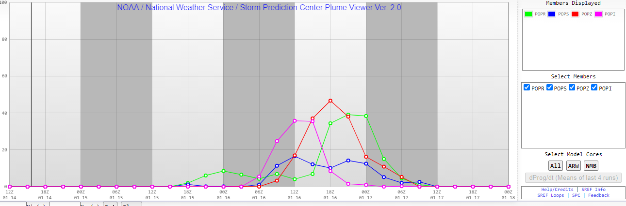
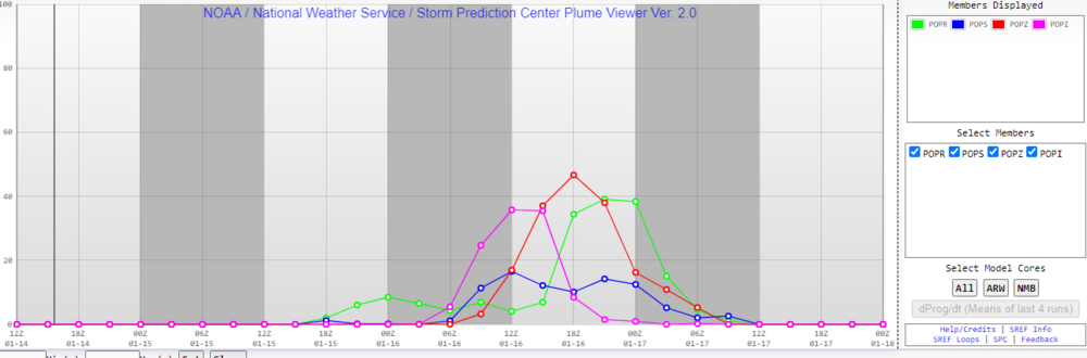
Really disappointing map for Charlotte. An inch of snow and then atleast a quarter inch up to a half inch of ice? Suddenly the same map when viewed for High end chance for a 1 in 10 chance of 1.5 inch. Yikes. GSP is suddenly very bearish.
-
With the potential of the warm-nose and mixed-precip, every bit helps! Would be great to get snow on the front end and back end.
-
Brad Panovich's call maps
-
This hasn’t really been a RDU storm for days
-
WINTER STORM WATCH ISSUED: 3:39 PM JAN. 13, 2022 – NATIONAL WEATHER SERVICE ...WINTER STORM WATCH IN EFFECT FROM LATE SATURDAY NIGHT THROUGH SUNDAY EVENING... * WHAT...Heavy mixed precipitation possible. Total snow accumulations of 6 to 8 inches over the northwest Piedmont, 4 to 6 inches along the I-85 corridor, 2 to 4 inches south of I-85, and ice accumulations of around three tenths of an inch possible. * WHERE...Portions of upstate South Carolina, northeast Georgia and the western Piedmont and foothills of North Carolina. * WHEN...From late Saturday night through Sunday evening. * IMPACTS...Power outages and tree damage are likely due to the ice. Travel could be nearly impossible. * ADDITIONAL DETAILS...Precipitation will begin Saturday evening and will gradually change over to a wintry mix across the region early Sunday morning, with mainly snow north of the I-85 corridor. A mix of all precipitation types is expected in the I-85 corridor. Freezing rain is most likely to affect the Lakelands and lower Piedmont of South Carolina, and the Charlotte metro area, on Sunday morning. Gusty winds may contribute to power outages. The precipitation should taper off Sunday afternoon and evening, perhaps as a period of light snow. Black ice could be a problem each morning early next week. Later guidance may affect precipitation types and amounts, and when a Warning would be issued. PRECAUTIONARY/PREPAREDNESS ACTIONS... A Winter Storm Watch means there is a potential for significant snow, sleet, or ice accumulations that may impact travel. Continue to monitor the latest forecasts. Stay tuned to NOAA Weather Radio or your favorite source of weather information for the latest updates. Additional details can be found at www.weather.gov/gsp.
-
I know we will get some snow in Charlotte but sure looks like alot of sleet, freezing, rain, and ice will mix in with it. Then when those backside winds hit it will be lights out.
-
Bad run for the Charlotte area with all that ZR
-
WInston-Salem is part of the Piedmont Triad (Greensboro-High Point-Winston Salem) and very much still central NC. Charlotte is not really WNC--its more of a south central NC. When I think of Western NC I think Anything including Hickory to the west (Asheville) and mainly the mountains. No one here in Charlotte thinks we are in western NC.