Silas Lang
-
Posts
733 -
Joined
-
Last visited
Content Type
Profiles
Blogs
Forums
American Weather
Media Demo
Store
Gallery
Everything posted by Silas Lang
-
January 15th-17th 2024 Arctic Blast/Snow Event
Silas Lang replied to John1122's topic in Tennessee Valley
Still ripping small to medium flakes. No mixing at 29 degrees. -
January 15th-17th 2024 Arctic Blast/Snow Event
Silas Lang replied to John1122's topic in Tennessee Valley
I am a few miles to your south in Fountain City. We are currently at 29. I will keep you posted on my temps. Should be enough of a barrier if Maryville is currently the rain line. Got to think the think coat of snow helps hold temps. -
January 15th-17th 2024 Arctic Blast/Snow Event
Silas Lang replied to John1122's topic in Tennessee Valley
Goodness. That's awful. Didn't think the rain line would make it that far up. Temp here is slowly climbing. At 29 now. See if snow cover helps temps stay down and prevent melting. -
January 15th-17th 2024 Arctic Blast/Snow Event
Silas Lang replied to John1122's topic in Tennessee Valley
Nice! So it looks like most in the central valley have 3 plus at this point. Any reports south of 40? Wonder where the heavy cutoff is. -
January 15th-17th 2024 Arctic Blast/Snow Event
Silas Lang replied to John1122's topic in Tennessee Valley
Hit the 3 inch mark here in Fountain City. -
January 15th-17th 2024 Arctic Blast/Snow Event
Silas Lang replied to John1122's topic in Tennessee Valley
Two and a half inches here. Accumulating much quicker this last hour. 28 degrees. -
January 15th-17th 2024 Arctic Blast/Snow Event
Silas Lang replied to John1122's topic in Tennessee Valley
A little over an inch here. Maybe an inch and a half. Light snow at 26 degrees. Ready for the onslaught! -
January 15th-17th 2024 Arctic Blast/Snow Event
Silas Lang replied to John1122's topic in Tennessee Valley
Yeah. I just stood outside and listened to it fall while staring at the street light. I live near the city, so it just makes everything so quiet. It's incredible. I love how snow just makes everything stop. lol -
January 15th-17th 2024 Arctic Blast/Snow Event
Silas Lang replied to John1122's topic in Tennessee Valley
Closing in on an inch here. Rates really picked up. Now at 26. -
January 15th-17th 2024 Arctic Blast/Snow Event
Silas Lang replied to John1122's topic in Tennessee Valley
Do any of you feel insane when it snows? Here I am, at 12:14 staring out the window, while everyone else is asleep. -
January 15th-17th 2024 Arctic Blast/Snow Event
Silas Lang replied to John1122's topic in Tennessee Valley
I don't think we will have to worry about temps in the day with a solid snow pack. Feels nice to finally have the cold air and moisture. -
January 15th-17th 2024 Arctic Blast/Snow Event
Silas Lang replied to John1122's topic in Tennessee Valley
About 15 minutes ago there was a half inch here in Knox. Roads now white! 27 degrees. -
January 15th-17th 2024 Arctic Blast/Snow Event
Silas Lang replied to John1122's topic in Tennessee Valley
I am going to need a drink after looking at the GFS. Goodness! -
January 15th-17th 2024 Arctic Blast/Snow Event
Silas Lang replied to John1122's topic in Tennessee Valley
It looks beefy to me. Which means it looks to encompass more north and south than some of the models indicated. Also considering the fact that I have had snow with zero returns over me is impressive. I was expecting a lot more virga. -
January 15th-17th 2024 Arctic Blast/Snow Event
Silas Lang replied to John1122's topic in Tennessee Valley
Yeah, crazy that it is just now starting. Seems like it is leaning towards an over performer,but I guess we will see! Any reports out west? -
January 15th-17th 2024 Arctic Blast/Snow Event
Silas Lang replied to John1122's topic in Tennessee Valley
Yeah, this storm could prove to be truly historic. A long duration, state wide mauler of a snow storm. Factor in the artic air and the fact that things will be shut down a few days...this one will be remembered. -
January 15th-17th 2024 Arctic Blast/Snow Event
Silas Lang replied to John1122's topic in Tennessee Valley
It's legitimately insane to me that tomorrow afternoon, nearly the whole state is still covered in snow on radar. It has been a long time since we have had a long duration event.
-
January 15th-17th 2024 Arctic Blast/Snow Event
Silas Lang replied to John1122's topic in Tennessee Valley

-
January 15th-17th 2024 Arctic Blast/Snow Event
Silas Lang replied to John1122's topic in Tennessee Valley
Yes. I already have a dusting. And then you look at the radar and nothing of note has even hit yet. lol
-
January 15th-17th 2024 Arctic Blast/Snow Event
Silas Lang replied to John1122's topic in Tennessee Valley
Same here in Fountain City. Just hit 32. -
January 15th-17th 2024 Arctic Blast/Snow Event
Silas Lang replied to John1122's topic in Tennessee Valley
Well then. I look forward to meeting Heather. -
January 15th-17th 2024 Arctic Blast/Snow Event
Silas Lang replied to John1122's topic in Tennessee Valley
Reading the latest MRX discussion, they seem to think most likely ratio is 12 to 1 to 15 to 1 ratios area wide. They only mention the southern border counties as the only exception. Seems they are not worried about warm air and also mention wherever the area of .50 to .80 precipitation sets up could get well beyond 6 inches. They seem very bullish overall. Don't see that often! -
January 15th-17th 2024 Arctic Blast/Snow Event
Silas Lang replied to John1122's topic in Tennessee Valley
Yeah I think a lot of bias is playing into the ratio forecasting much like mixing is. I think the depth and strength of the cold isn't really being modeled well by most and that ratios will be higher likely than most models are showing. So...if this bias is showing in the short range models, does that mean some locations could possibly see something like 50% more snow than modeled? Goodness. -
January 15th-17th 2024 Arctic Blast/Snow Event
Silas Lang replied to John1122's topic in Tennessee Valley
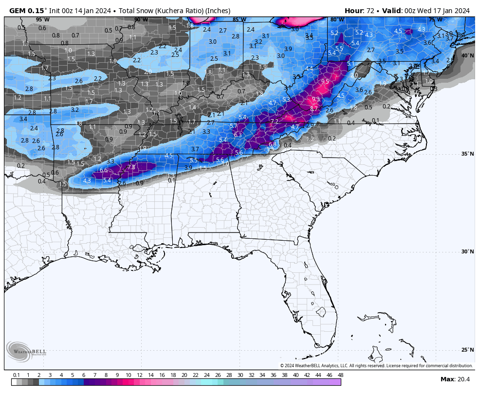
Here is the Canadian
-
January 15th-17th 2024 Arctic Blast/Snow Event
Silas Lang replied to John1122's topic in Tennessee Valley
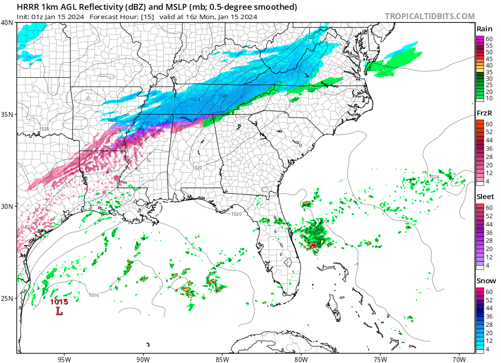
And here is the 0z GFS