

Silas Lang
-
Posts
733 -
Joined
-
Last visited
Content Type
Profiles
Blogs
Forums
American Weather
Media Demo
Store
Gallery
Everything posted by Silas Lang
-
Looks like the valley could have freezing fog in the am? Take a look at this:
-
A cold 39 degree rain here.
-
I mean, yeah we are probably out of it, but maybe a miracle happens. I just walked the dog and the wind was ripping from the north. Maybe that's a good omen. Fingers crossed.
-
Yeah, looks like it has caved to other guidance.
-
Maybe I am reading the tea leaves too much here, but I really don't understand how these models are showing most of East TN below freezing Sunday night and Monday morning if there is no snow. There is not a real cold air mass around and on a lot of model output it looks like it would be modeling the impact of snow on the ground, even when there is none according to the model. I guess this kind of goes along with what 1234snow just posted about the sounding versus the simulation the models are spitting. A lot is not adding up.
-
Yeah, that's looking like what we are going to have to do considering all the variables. Really think this could go any which way and everything is still on the table at the moment.
-
I don't think any adjustments are off the table just yet either. One small move in the track could lead to more favorable results. Not like we need a huge change.
-
Pretty good discussion for MRX. They seem to think it will be snow everywhere in the area by Sunday morning, which I found surprising, as the models have been trending mostly rain in the valley. Plateau and Mountains obviously favored for accumulation. The mid/upper low will be the main driver of our weather from Saturday night through Sunday night. Isentropic lift will spread rain to the area from south to north late Saturday and into the evening, with a top-down moistening of the column. Evaporative cooling will initially be offset by an easterly flow with warm advection and downsloping winds in the Valley. After midnight, the freezing level drops as the upper low tracks into GA, and mountain tops should begin to see snow by midnight. Forecast soundings show a deep layer from the surface up to 700 mb that is nearly isothermal, from 1-4 degrees above freezing. From 12-15Z, the top of this layer cools under the upper low, while surface temps remain several degrees above freezing, and this continues through Sunday. On the NW side of the circulation, a deformation zone will set up across Middle TN, and track into KY and WV through Sunday. Frontogenetic forcing in this area may result in some heavier precip rates. Snow accumulations will be highly dependent on temperatures, not only at the surface but up to 700 mb. In these situations, the precip rate can make a big difference in how much precip falls as snow, and how much can accumulate. This makes the forecast highly uncertain. Snow is expected to be falling nearly everywhere on Sunday morning, but temperatures in most spots outside the mountains will be in the mid to upper 30s, making accumulation difficult. An exception may be where snowfall rates are high enough to cool temps closer to freezing. As mentioned above, the favored area for this to occur in a frontogenesis zone near the Plateau and SW VA. This is the area of lowest confidence. Confidence is higher that impactful snow amounts will be in the TN mountains, and that much of the TN Valley will have little to no accumulation. Based on this reasoning, a Winter Storm Watch will be issued for the TN mountains from midnight Saturday night to midnight Sunday night.
.gif.0f677bec50a725fe0a54d4055be81ac2.gif)
-
It wasn't a whole lot. Think around an inch or two in most of the valley. Still, a better solution than the rest of modeling at this point.
-
Euro took a step back towards snow.
-
LOL not the trends we want to see. Looking like a bone chilling rain for a lot of us with the exception of places on the Plateau and mountains. And even then totals have pulled way back.
-
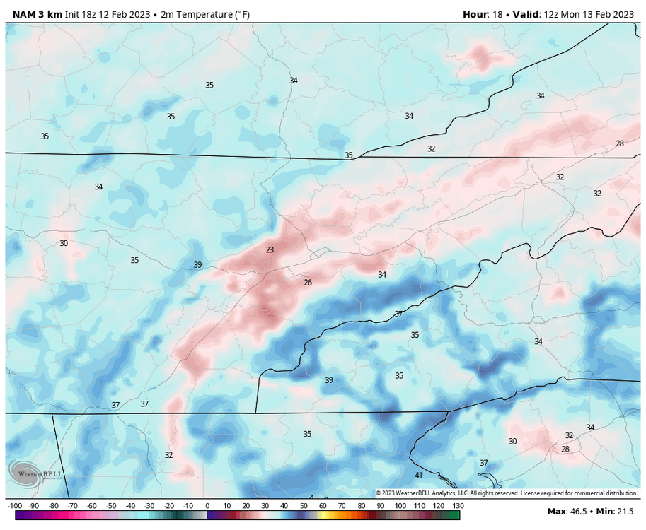
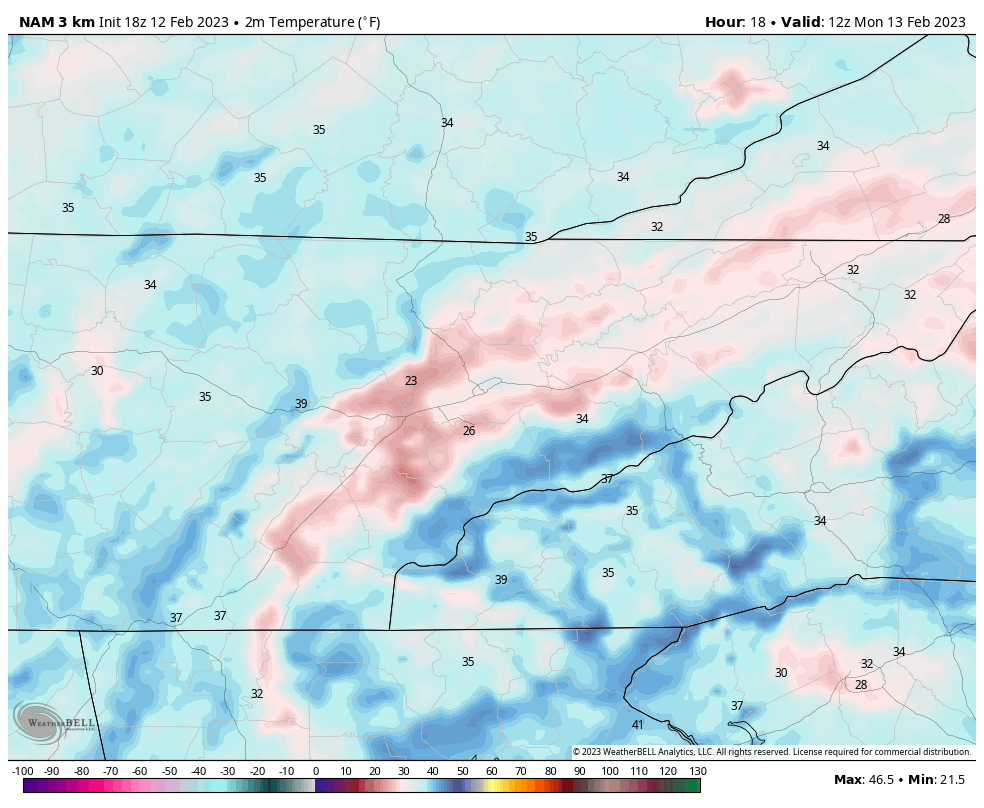
The GFS ain't as bullish either. Temps are way warmer at the surface. For example, has TYS at 40 on Sunday at 7:00 AM. The NAM had a temp of 33. Pretty big difference. GFS still has snow, though more elevation driven.
-
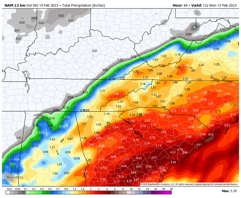
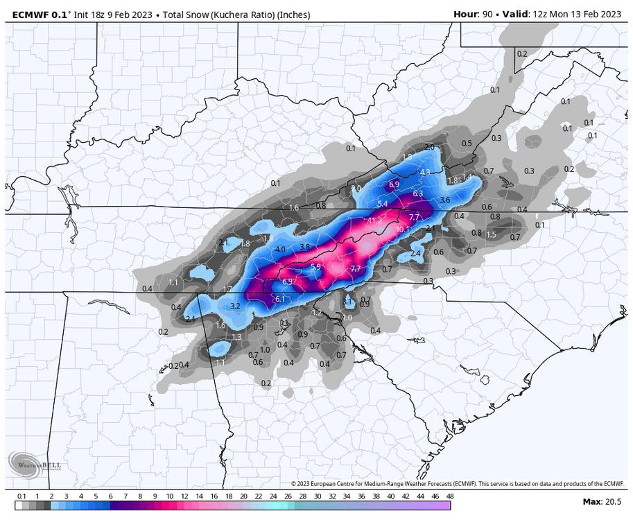
lol yeah, I was just looking at the map on weatherbell and saw the same. A much more reasonable expectation. If I can just get an inch, I will claim victory. Anyway, to get an idea of how wet this system here is the precipitation map. Looks like Blount, Sevier, and Cocke have a lot of potential. 2 inches of water to work with, though I assume the ratios are low? Less than 10?
-
I know there is probably a lot of melt and this is with marginal temps, but that's a straight up paste bomb. Goodness the mountains and foothills look to clean up on this run.
-
Top is 12z and bottom is 18z for comparison. The latest run gets a little more of the plateau involved.
.thumb.png.d79bde90745e5cde6650bac53081cad4.png)
-
Well there is a bit of a lower precipitation total near JC on that run. That's a possibility. I know these set ups are rate driven. I think Powell mentioned it this morning that the models sometimes struggle picking up the dynamic cooling aspect of these storms. That could be a possibility as well. Or maybe we just get cold rain. lol
-
NAM shows some mixing and thermal issues. Pretty weird looking clown map. Suggests most go from snow to rain. Just weird to see TRI blanked when the Euro has it getting crushed. Any thoughts?
-
Where has he been? I miss his posts. He usually provides some good historical analysis when looking at potential systems.
-
Seems like this thing is trending slower as well. Wonder if we could trend to a more ideal period of snow on Sunday night as opposed to the day time?
-
Maybe it's somewhere in the middle? Seems the models have done that a lot this winter. Two different solutions with a slow trend towards each other.
-
Yeah, agreed. When you look at that Canadian run it looks like most of the east gets under heavy precipitation, but most shows up as rain.
-
Canadian is a beautiful rainstorm with a weird southern plateau jackpot of snow.
-
Will say, at a quick glance it did seem warmer though. Very close temps. Like any closer and this will be a monsoon. lol
-
A tick back to the west on the GFS. TRI and the mountains would love that outcome. Pretty steep cutoff. Wouldn't take a lot to get more people involved.


.png.95ab190ad7e57b590a6ec99b515b48ec.png)
