

The Ole Bucket
-
Posts
556 -
Joined
-
Last visited
Content Type
Profiles
Blogs
Forums
American Weather
Media Demo
Store
Gallery
Everything posted by The Ole Bucket
-
We were supposed to get a full day of freezing rain with the last storm and instead it was on-and-off and mixed with far more sleet than forecast or modeled..
-
Whatever north trend the NAM had seems to have stopped.
-
26/13 in CHO. Was actually pretty bitter this morning going into the gym. Wind was up a bit.
-
One other thing that I'd cheer for that the models are showing... getting at least partially dry slotted after snow/sleet moves through. Please keep the big icing away, thanks.
-
I know it's at range but I actually think the HRRR is showing something that's... likely? Possible at least? Going to be a lot of flipping and weird pockets of cold/warm air at 700. It just feels like that kind of storm where there will be sleet bombs in some areas while others not far away hang onto to much more snow.
-
7+ for CHO and about 6" for DC according to Kuchera through 30 on the long range HRRR...
-
Wait now there are TWO “claws”?
-
Sterling getting slightly snowier..
-
Well in fairness this is his opinion of trying to forecast it:
-
One local met's take on the forecast for CHO anyway.
-
NAM 3K gives DC like.. 90 minutes of snow before sleet comes in.
-
Long and short it seems to me that the NAM is trending colder. I think the trajectory of this thing is locked in. All that matters are the 700mb temps.
-
Wait actually I'm wrong on the juice if you look farther west. There was a kind of a snow hole in WV in prior runs. That's GONE.
-
I'm not the best at reading the maps, but so far to me the NAM seems slightly less amped and a ever so slightly more south than 12z. CHO still all sleet verbatim, but I don't buy that.
-
NAM at 42 is a direct hit for DC.
-
Look at that EZF jackpot from the Ukie.
-
Well @NorthArlington101 I think we both know that CHO and other points southwest of NOVA/DC/MD are not gonna get those totals!
-
An inch and a half of sleet, a few inches of snow and a trace of ice for CHO says the GFS. Well at least it will be like 50 a few days later. That's going to be hell to clean up.
-
That's a hit across the entire forum... except Short Pump/RIC. And it's all in like 6 hours. Would be some really insane rates.
-
It's going to be just disgusting across much of central VA it seems. I guess maybe we'll get a nice freeze over with it? I dunno. Rooting for folks to the north who missed the earlier storms to get plastered. Absolutely laughing at the 6Z GFS that verbatim gives CHO 9.9" according to Kuchera. No way in the world that happens. LOL the 10:1 has us at nearly 12". Clearly drunk.
-
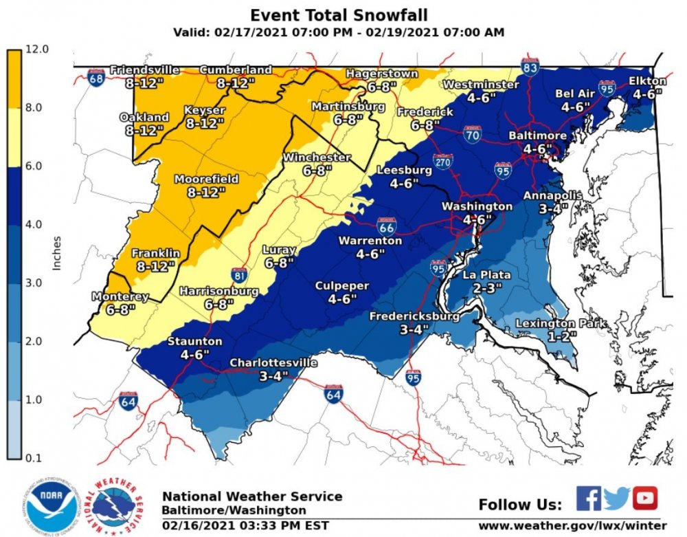
Orange from Sterling? That's a downgrade for the Piedmont..
-

Feb Long Range Discussion (Day 3 and beyond) - MERGED
The Ole Bucket replied to WinterWxLuvr's topic in Mid Atlantic
Score -
Feb Long Range Discussion (Day 3 and beyond) - MERGED
The Ole Bucket replied to WinterWxLuvr's topic in Mid Atlantic
Ah just what I wanted was a half-inch of ice... or more. I guess this is revenge for dodging any impact from the last storm. -
If you all want a taste of winter, come down to CHO. Snow is compacted and now has a small layer of ice on it... still a few inches though. Roads are very driveable because all ZR and sleet fell during the day. It’s an icy and snowy wonderland for the first time in years.
-
Absolutely pelting sleet in CHO


