The Ole Bucket
-
Posts
567 -
Joined
-
Last visited


-

MO/KS/AR/OK 2025-2026 Winter Discussion
The Ole Bucket replied to stormdragonwx's topic in Central/Western States
Windchill is already subzero here in SEMO. Extremely dry though. -
MO/KS/AR/OK 2025-2026 Winter Discussion
The Ole Bucket replied to stormdragonwx's topic in Central/Western States
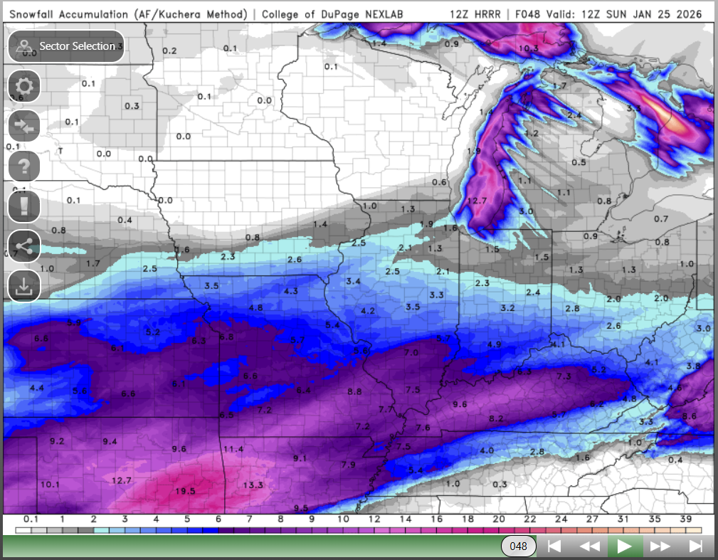
The 12z long-range HRRR is a thing of beauty. Would pay big bucks for this to verify, unlikely as that is
-
MO/KS/AR/OK 2025-2026 Winter Discussion
The Ole Bucket replied to stormdragonwx's topic in Central/Western States
A perfect run showing how the NAM is always wetter and warmer than what verifies. Classic stuff. -
MO/KS/AR/OK 2025-2026 Winter Discussion
The Ole Bucket replied to stormdragonwx's topic in Central/Western States
NWS STL finally getting fully onboard.. -
MO/KS/AR/OK 2025-2026 Winter Discussion
The Ole Bucket replied to stormdragonwx's topic in Central/Western States
-
MO/KS/AR/OK 2025-2026 Winter Discussion
The Ole Bucket replied to stormdragonwx's topic in Central/Western States
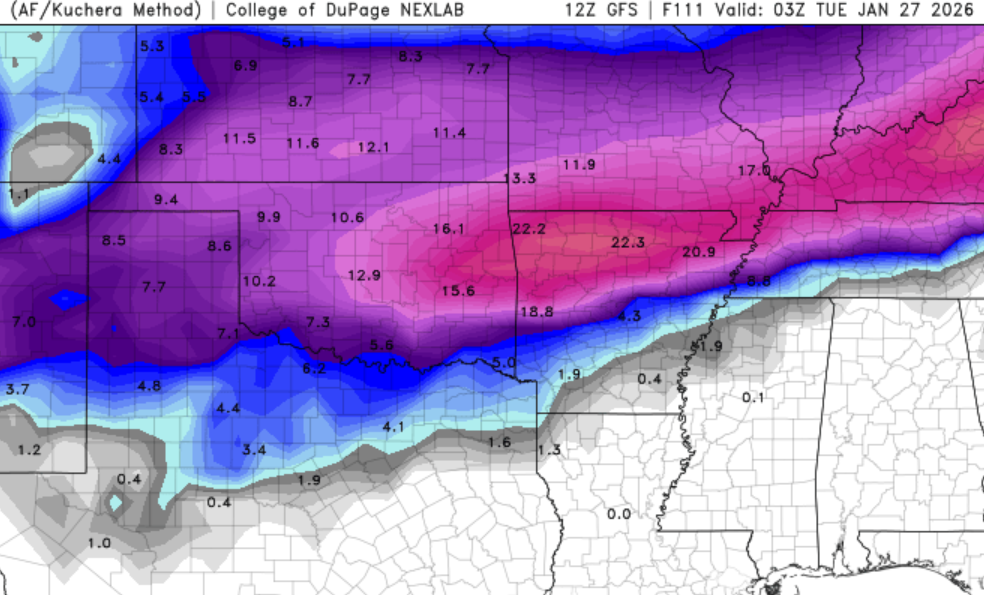
12Z GFS running and seems really similar to last run -
MO/KS/AR/OK 2025-2026 Winter Discussion
The Ole Bucket replied to stormdragonwx's topic in Central/Western States
I imagine they are concerned with mixing to the south and east, but from Cape on north there isn't gonna be any mixing so the disparity is crazy. -
MO/KS/AR/OK 2025-2026 Winter Discussion
The Ole Bucket replied to stormdragonwx's topic in Central/Western States
NWS STL hedging quite a bit -
MO/KS/AR/OK 2025-2026 Winter Discussion
The Ole Bucket replied to stormdragonwx's topic in Central/Western States
Yeah feels a lot more likely that the models will factor in the strong arctic high/blocking and how dry it is and create sharper northern cutoffs than there be a temp thing going on. The cold is legit. -
MO/KS/AR/OK 2025-2026 Winter Discussion
The Ole Bucket replied to stormdragonwx's topic in Central/Western States
Time to start the windshield wipers and bring this back south a little bit so everyone can get in on the fun. -
MO/KS/AR/OK 2025-2026 Winter Discussion
The Ole Bucket replied to stormdragonwx's topic in Central/Western States
We had about 2" of wet snow in the last system that melted/was washed away within hours. No advisory for that. But they finally went ahead and gave us our first WWA of the season in SEMO for this one. A few flakes falling out there now. -
MO/KS/AR/OK 2024-2025 Winter Discussion
The Ole Bucket replied to JoMo's topic in Central/Western States
I could complain that we didn't get more, but what's the point? A decent result here in southeast Missouri (about 6") and bitterly cold this morning. -
MO/KS/AR/OK 2024-2025 Winter Discussion
The Ole Bucket replied to JoMo's topic in Central/Western States
Likely going to score a quick inch this morning here in SEMO before the main event. -
MO/KS/AR/OK 2024-2025 Winter Discussion
The Ole Bucket replied to JoMo's topic in Central/Western States
Well since it completely plasters my backyard I would say now -
MO/KS/AR/OK 2024-2025 Winter Discussion
The Ole Bucket replied to JoMo's topic in Central/Western States
A foot of pure powder IMBY according to the 18Z GFS (Kuchera) I would gladly take half of that!