

T. August
-
Posts
4,612 -
Joined
-
Last visited
Content Type
Profiles
Blogs
Forums
American Weather
Media Demo
Store
Gallery
Everything posted by T. August
-

The Weekend Rule? Saturday 2/17 - The Icon Storm
T. August replied to DDweatherman's topic in Mid Atlantic
My strategy is to set an alarm for 2:00AM. That way I don’t have to stress about first flakes, and it will be ripping. -
The Weekend Rule? Saturday 2/17 - The Icon Storm
T. August replied to DDweatherman's topic in Mid Atlantic
Yeah I noticed that too. My biggest takeaway is that the NAMs don’t show the claw… which is great lol. -
The Weekend Rule? Saturday 2/17 - The Icon Storm
T. August replied to DDweatherman's topic in Mid Atlantic
Didn’t see it posted… LWX slashed totals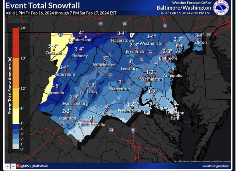
-
The Weekend Rule? Saturday 2/17 - The Icon Storm
T. August replied to DDweatherman's topic in Mid Atlantic
The euro hates me -
The Weekend Rule? Saturday 2/17 - The Icon Storm
T. August replied to DDweatherman's topic in Mid Atlantic
18z gefs not bad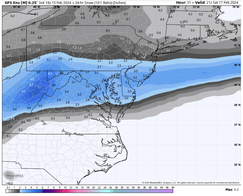
-
The Weekend Rule? Saturday 2/17 - The Icon Storm
T. August replied to DDweatherman's topic in Mid Atlantic
A little more falls after that too. Really good baltimore run. -
The Weekend Rule? Saturday 2/17 - The Icon Storm
T. August replied to DDweatherman's topic in Mid Atlantic
What is that product? -
The Weekend Rule? Saturday 2/17 - The Icon Storm
T. August replied to DDweatherman's topic in Mid Atlantic
@Interstate@North Balti Zen There’s our triangle on the euro -
The Weekend Rule? Saturday 2/17 - The Icon Storm
T. August replied to DDweatherman's topic in Mid Atlantic
Verbatim on the Canadian it’s all snow but you’ll be fighting sfc temps. 34-35° during the heaviest. -
The Weekend Rule? Saturday 2/17 - The Icon Storm
T. August replied to DDweatherman's topic in Mid Atlantic
Canadian is wetter but not the best precip distribution.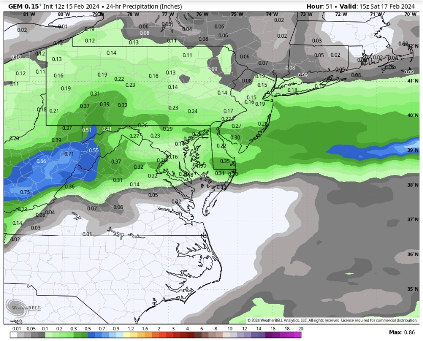
-
The Weekend Rule? Saturday 2/17 - The Icon Storm
T. August replied to DDweatherman's topic in Mid Atlantic
Lol 2016 I got fringed hard. About 20” here with 36” in Bel Air. -
The Weekend Rule? Saturday 2/17 - The Icon Storm
T. August replied to DDweatherman's topic in Mid Atlantic
A triangle from you to me down to baltimore has been getting screwed. Also you should never have the same amount of snow as me lol -
The Weekend Rule? Saturday 2/17 - The Icon Storm
T. August replied to DDweatherman's topic in Mid Atlantic
Both NAMs were a little dry and boring lol -
The Weekend Rule? Saturday 2/17 - The Icon Storm
T. August replied to DDweatherman's topic in Mid Atlantic
18z gefs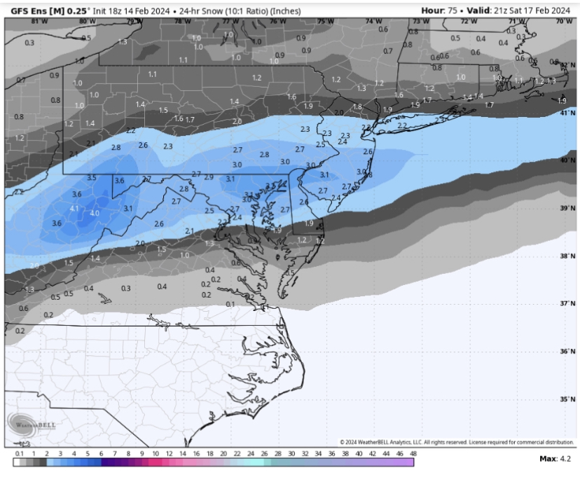
-
The Weekend Rule? Saturday 2/17 - The Icon Storm
T. August replied to DDweatherman's topic in Mid Atlantic
12z euro ens juiced up a little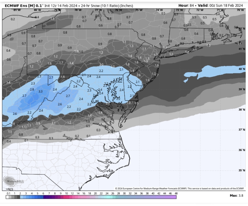
-
The Weekend Rule? Saturday 2/17 - The Icon Storm
T. August replied to DDweatherman's topic in Mid Atlantic
It’s a little worse for our area but definitely wetter overall. -
The Weekend Rule? Saturday 2/17 - The Icon Storm
T. August replied to DDweatherman's topic in Mid Atlantic
0z gefs. Improvement over 18z.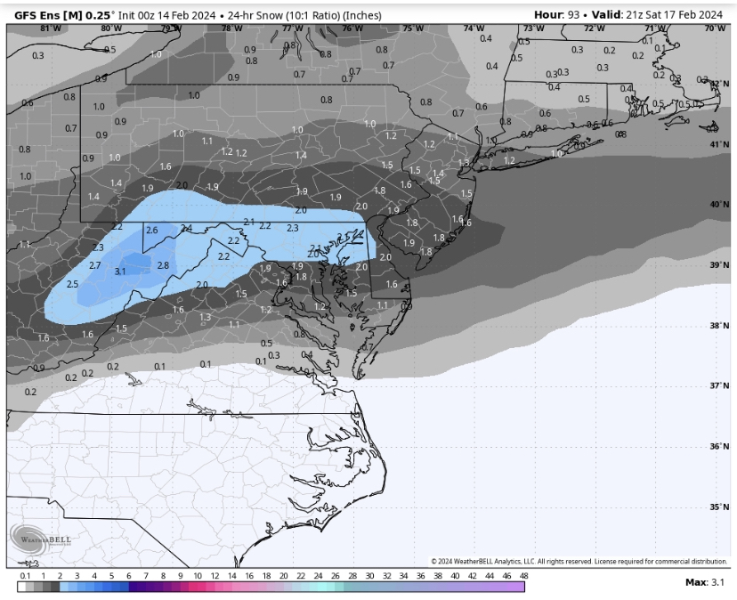
-
2024 Valentines Day Who the Hell Knows - Comeback Thread
T. August replied to DDweatherman's topic in Mid Atlantic
Lol Churchville MDOT shop measured 3.5”. Total BS. My cousin’s house NE of there got 2”. -
2024 Valentines Day Who the Hell Knows - Comeback Thread
T. August replied to DDweatherman's topic in Mid Atlantic
Yeah the north end of the city up near 95 is over 400’. My house is at 30’ lmao -
2024 Valentines Day Who the Hell Knows - Comeback Thread
T. August replied to DDweatherman's topic in Mid Atlantic
Lol the season -
2024 Valentines Day Who the Hell Knows - Comeback Thread
T. August replied to DDweatherman's topic in Mid Atlantic
8.3” -
2024 Valentines Day Who the Hell Knows - Comeback Thread
T. August replied to DDweatherman's topic in Mid Atlantic
This event was a little heartbreaking for me. Looks like the line was at 150’. I could literally watch the snow depth drop off on the way home. Within the city limits of Havre de Grace there are spots with 2”+. -
What pisses me off is I think it’s actually colder than modeled. But then the dryslot happened. Ridiculous.
-
2024 Valentines Day Who the Hell Knows - Comeback Thread
T. August replied to DDweatherman's topic in Mid Atlantic
34° and mangled flakes in Havre de Grace. Now the dryslot. -
2024 Valentines Day Who the Hell Knows - Comeback Thread
T. August replied to DDweatherman's topic in Mid Atlantic
41/40 in Havre de Grace. Was hoping for upper 30s by midnight.


