

CPcantmeasuresnow
-
Posts
2,126 -
Joined
-
Last visited
Content Type
Profiles
Blogs
Forums
American Weather
Media Demo
Store
Gallery
Everything posted by CPcantmeasuresnow
-
Enjoy your time away Walt but I fully expect you back by late October when especially here in the interior northern burbs we start looking for our first measurable snows and we can’t do it without you. Thanks for all of your input and see you around October 25th for full time duty. Rest up and enjoy life till then. Hopefully next winter you’ll have lots more threads to create.
-
Currently 18° morning low of 14°, windy as hell brutal out, 6.5 inches of snow otg. 34 consecutive days with snow cover and 30 days consecutive above half a foot, 44 days of snow cover for the winter. One of my criteria for a winter to be a C+ or above is 30 consecutive days of snow cover at some point and at least 50 days in total. It looks like both will be met this year. At 59.4 inches for the season now, which is already 10 inches above normal for a full season, any half way decent March should grade this winter out as a B. If somehow we had snow cover for almost all of March this still has B+ potential, however atm that looks unlikely.
-

Possible Major Winter Storm/Coastal 3/6 - 3/8
CPcantmeasuresnow replied to Northof78's topic in New York City Metro
I guess it's just a different world there. I'm only 45 miles by way of the crow north of NYC and at elevation of 620 feet, most of Orange County is 500 to 1000 feet above sea level except those towns right on the river, and I had 50 inches of snow March 2, 2018 through April 2, 2018. The first three weeks of March is just a continuation of winter here in most years. Very different climates in this sub forum. -
8.5 inches otg this morning. 59.4 inches for the season, 36° currently. As I've stated Ad nauseam the last several days this snow pack is not going anywhere quickly. February was a very good month for snow pack, with over a foot on the ground for 24 of the 28 days. I'll sign for that any year. January was bad, pretty snowless and above normal temps, and December was ruined by the Christmas Eve nightmare which washed away a beautiful white Christmas in one horrifying night. It will be up to March whether this winter grades exceptional or just okay. We shall see.
-
Possible Major Winter Storm/Coastal 3/6 - 3/8
CPcantmeasuresnow replied to Northof78's topic in New York City Metro
I think it may be time to shut down this thread. Was opened to early and nothing but bad runs since. We were on a nice hot streak with Walt creating these threads. Why change now, ride the hot hand. -
Will easily get through tomorrow with full snow cover. The question is will we make it to the next snowfall, if there is one next weekend, with snow cover.
-
Cloudy 40° still 9 inches otg. A different world here in the HV.
-
0.7 inches of snow last night, very cold drizzle now at 33.6° Snowpack holding up solid at an even 10 inches otg. will be interesting to see where it stands Monday morning. My guess would be 8 inches. This isn't going away quickly.
-
10 inches even otg this morning. As I stated yesterday we now appear to be at the concrete level of the snowpack. Only lost 1/2 an inch yesterday despite full sunshine and a high of 43° No pictures will be provided. If we can't have trust in our stated snow measurements then what hope is there for us to move forward as a country. If we falsify our snow depth the terrorists win.
-
It looks like today we have reached that hardened, time tested, compressed, frozen level of the snowpack that will be difficult for even the late February and early March sun to penetrate. I started this morning with 10 1/2 inches of snow on the ground and as of 3 o'clock this afternoon I'm sitting with 10 inches even. This despite a full day of sun and temperatures currently in the low 40s. Now I can't promise how it will hold up to rain and low 40s this weekend but I think it will be more resilient than many people think. This of course is just discussion for the Northeast Pennsylvania, Northwest New Jersey, Hudson Valley, Catskill, and Western Connecticut area. This theory does not apply to any of the urbanized areas south of that line.
-
I would hope so. As I would also hope you were not EPICHECS in a past life.
-
My condolences. I didn't realize east of the Hudson the snowpcak was that low.What are your YTD and monthly totals Julian?
-
I think here at least it does, although yesterday did take a toll. I went down from 14 otg yesterday morning to 10.5 otg this morning. This morning becomes my first day with less than a foot otg this month. It was a good 24 day run but not fantastic, like I've never seen, historic, or any of the other hyperbole you may read in the other sub forums from some who act as if they see snow every five years or so. Who knows maybe on the Jersey shore that's their climate, one reason I don't live there.
-
27° with a 14 inch snow pack and a bit of a warmup on the way. So far I have not had a day in February with less than 12.5 inches of snow otg. Maximum depth was 26.5 inches the evening of February 2nd. Will be interesting to see if we can make it through Sunday with at least a foot on the ground for the entire month, with no significant snow forecast through Sunday it will be close. The liquid equivalent of the snowpack right now is at least 3 inches probably close to four. That will make this 14 inches of snow on the ground right now like melting 3 to 4 feet of snow, it will be tough to do even for a late February sun with temperatures in the low 40s. My guess looking at the forecasts is I'll probably be down to 10 inches on the ground by the end of the day Sunday
-
He was a loose cannon to put it kindly and I applaud his exile, but he did call out Rob for under measuring, snow melting before he measures, and inebriated measuring. If the allegations are true Rob had us fooled all these years, I feel betrayed.
-
17 inches otg right now and I could only guess, because I'm to lazy to actual melt it down, but I would say at this point the LE is 3-4 inches. This is the same as having 3-4 feet of snow otg for melting purposes. We will have snow cover here until mid March if it doesn't snow again, but I would hope it does, at least a couple of more times.
-
Please see an Exorcist because that can't be you speaking. "The power of Christ compels you"
-
3.4 here too, 17 inches otg, 40.7 inches for the month and 58.7 for the season. It's the most snow I've had in this short a stretch since March 2018 when imby I had 49.6 inches between March 2 and April 2. This of course is better because the snow pack has not had to deal with the March and early April sun.
-
It's been a great February but still not quite on the level of February 2014. That was a little colder with a bit more snow imby, 41.7 inches vs 40.7 inches this February. NYC had 29 inches then in the Park vs 26 inches so far this February, and in the time remaining it doesn't quite look like February 2021 will surpass it. Although imby I might.
-
There are so many inaccuracies in the above quotes I don't know where to begin, so I won't.
-
OBS and nowcast 10A-5P both Mon and Tue 2/22-23
CPcantmeasuresnow replied to wdrag's topic in New York City Metro
Still snowing moderately so may add several more tenths today. Had 1.0 inch by midnight January 31 so storm total was 27.4 for the Feb 1 storm.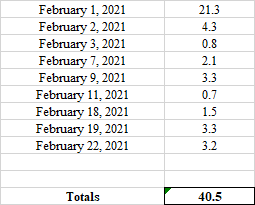
-
Meant to post this here. I'm not quite sure why I bother in the main spread. Some there are already hoping for flowers and warm weather in March. Yeah that happens a lot around here 31.3° moderate snow, 3.2 inches so fa, doesn't look like will make it to 4. 58.5 inches on the season, 17 inches otg, and not one day in February so far with a snow depth below 12.5 inches, and 40.5 inches for the month. That is an A+ month in my book.
-
OBS and nowcast 10A-5P both Mon and Tue 2/22-23
CPcantmeasuresnow replied to wdrag's topic in New York City Metro
31.3° moderate snow, 3.2 inches so far, doesn't look like will make it to 4. 58.5 inches on the season, 17 inches otg, and not one day in February so far with a snow depth below 12.5 inches, and 40.5 inches for the month. That is an A+ month in my book. -
OBS and nowcast 10A-5P both Mon and Tue 2/22-23
CPcantmeasuresnow replied to wdrag's topic in New York City Metro
2.7 inches so far, up to 31.1° heavy snow. We may make it to 4. atm 58 inches even on the season, -
30.9° moderate/heavy snow 1.75 inches so far. If this makes it to 3-4 inches no complaints.


