HVSnowLover
-
Posts
2,952 -
Joined
-
Last visited
Content Type
Profiles
Blogs
Forums
American Weather
Media Demo
Store
Gallery
Everything posted by HVSnowLover
-
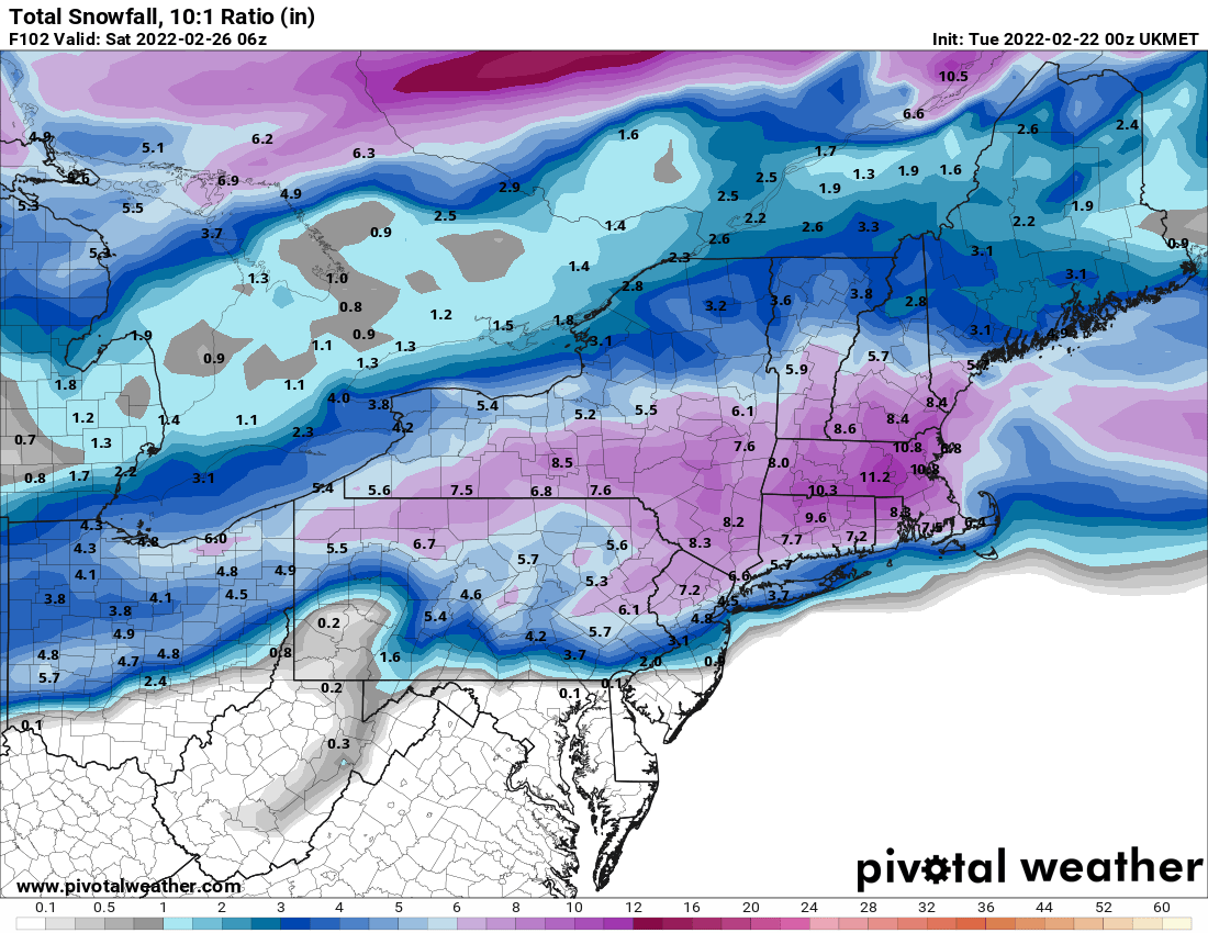
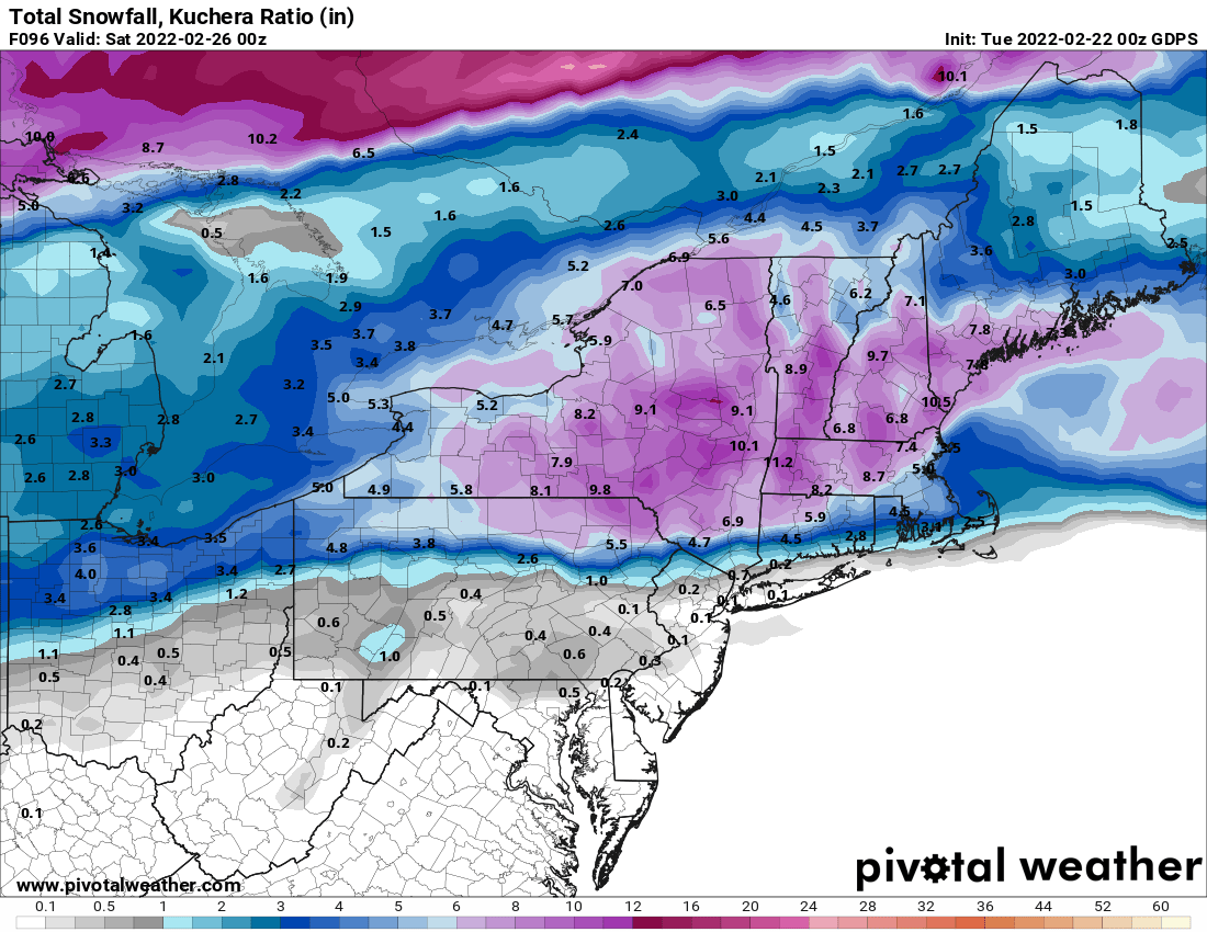
No significant changes so far on 12z suites, GFS snow distribution still looks weird and CMC still torching the mid levels for everyone in the subforum.
-
I said I hoped the south trend would continue because they usually bump north. If the 12z runs go back north it's not a good sign at all for south of I84. For any kind of real snow we need them to at least stay the same or go even further south.
-
It's still kind of early i think for the noted March urban heat island effect on winter storms so to speak but I think in this case its primarily due to the fact the mid and upper levels are warming from the SW so further east may benefit.
-
We know these tend to bump north so to think we get a decent event would like to see the south trend continue through tomorrow.
-
Ukie wow

-
The 0Z CMC is a thing of beauty for your area, thinking this may finally be the I84 to I90 snowstorm but hopefully south of their can cash in on at least some snow.
-
0Z CMC also trended colder, still sleet for the city but the snow line moved closer.
-
0Z GFS coming in way snowier
-
A good week for NYC at this point would be more than 2 inches and stay mostly frozen Friday and then Sundays storm comes west and is a hit. A bad week would be complete miss on snow for both storms.
-
I think I95 and points east the Sunday storm has way more potential than Friday but I agree probably would be cautious to make a thread until models are showing a more consistent hit.
-
Impressive as it doesn't rise very fast?
-
It started off improved but then got kind of messy and ugly. Still time to go with this.
-
GFS has gone from the cold outlier to one of the warmer models now in the mid levels.
-
Very detailed, like it.
-
I agree the sleet is the real story here for the metro area. Probably have a better idea by late tomorrow if the storm will be mostly wet or icy.
-
I don't think anyone is calling for a big snowstorm south of I84. A sloppy mess is most likely with maybe a few inches of snow at the start. We still have about another 24 hour window for any meaningful changes.
-
If it does end up 80% frozen it will probably be mostly sleet changing to a little rain at the end. ZR unlikely in NYC and also the antecedent airmass is not that cold.
-
Pretty much every model now spitting out over 1 inch liquid so difference between 31 and 33 will be big with this storm from a washout to a giant mess.
-
At hour 96 (height of precip) 850/925 temps below freezing on Euro for parts of the city. Thats a frozen precip signal to me.
-
As you said this morning not getting a snowstorm in NYC with a primary going into PA no matter what happens with secondary. However some snow with a wintry mix definitely still on the table. Looking decent for HV and SNE.
-
Looking at 12Z runs might need a thread for Sunday soon. It's close.
-
12Z Euro is decently improved, still don't think it'll be enough for the coast but starting to think I287 to I84 corridor still in play for a solid event.
-
The qpf seems to waffle around every run but seems about .75 to 1.25 is a reasonable expectation for most of the area. Thats usually what you get with these kinds of systems. The more amped the more qpf but also more mixing.
-
Yea upper levels warm up a bit more but surface is a little colder this run.