

HVSnowLover
-
Posts
2,952 -
Joined
-
Last visited
Content Type
Profiles
Blogs
Forums
American Weather
Media Demo
Store
Gallery
Everything posted by HVSnowLover
-
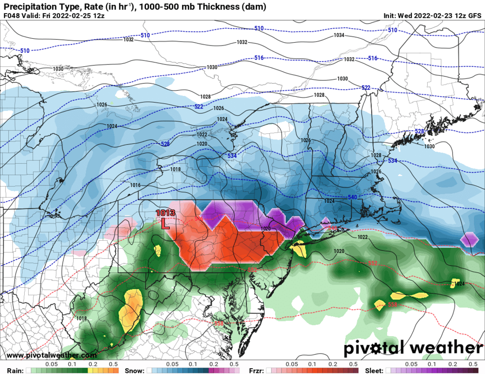
Wow warning level snow to the Bronx border.
-
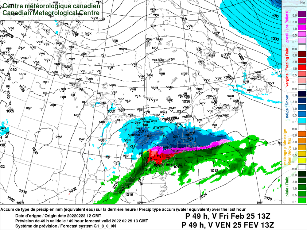
In this case the NAM is not just showing a warm tounge, its basically showing an entirely different storm track with a primary up to Western NY and a secondary over Cape Cod.
-
Sounds like heavy sleet could qualify for a winter storm warning.
-
It will be interesting to see if these gradients actually verify or if the mid levels are warmer than most models are picking up on but outside of the NAM almost every model is now trending toward a very tight gradient somewhere near HPN.
-
What is criteria for an ice storm warning? It seems like it's just based on ZR but in this case it seems like it will be heavy sleet and maybe some ZR so that we more a winter storm warning?
-
I love your posts and analysis but in this case I disagree if you are implying NYC is likely to change to meaningful rain. Almost every model is keeping NYC mainly frozen except the NAM, I think it's at least 75% frozen for everyone in the metro area except maybe eastern LI/South shore beaches. NVM I think I took your post out of context and saw your previous post about EWR/NYC/LGA so I agree.
-
The NAM is so far off from the other models it's not even funny right now and it hasn't exactly been scoring coups this winter.....
-
How is it going to plain rain up to I84 with a strong high to the north?
-
I agree with uptons watch area, a significantly impactful frozen event is likely in that zone regardless of precip type. South of there it still seems more iffy and we'll have to watch the trends.
-
https://www.pivotalweather.com/model.php?rh=2022022312&fh=60&dpdt=&mc=&r=us_ne&p=sn10_acc&m=ukmet https://www.pivotalweather.com/model.php?m=gdps&p=sn10_acc&rh=2022022312&fh=66&r=us_ne&dpdt=&mc=
-
Ukie bumped north and really backed off on totals. CMC came south though Maybe snowman will be right or maybe not. Models may be meeting more in the middle as opposed to a big trend.
-
They are wrong then? https://forecast.weather.gov/showsigwx.php?warnzone=NYZ070&warncounty=NYC119&firewxzone=NYZ070&local_place1=2 Miles NNW Maryknoll NY&product1=Winter+Storm+Watch&lat=41.2118&lon=-73.842#.YhZgyZPMKEI
-
-
Yea GFS is not the model i'd use to forecast precip types anyway I'm just being fair to show all the different possibilites here.
-
Referring to this, not saying it's right
-
Until the 12Z GFS came and has NYC pouring at 12Z on Friday but the GFS has been attrocious model with this storm so take it for what its worth.
-
You can see how shallow the warm layer, would not be surprised at all if snow mixes in with the sleet during the heavier precip.
-
The window for NYC going above freezing seems to be about 10 am to 4 pm but by then most precip is gone with this one. Central and Eastern LI would probably see a period of plain rain after 10 am.
-
Although RGEM is out of range since we are looking at all models it actually nudged a bit south with snow this run from 6Z. It has also has over an inch of precip of almost entirely Sleet/ZR for NYC.
-
The NAM always does this, overamps and then adjusts. Not really considering this a true north trend until globals come north or NAM is still showing this inside 36 hours.
-
I guess Upton has a different feeling than many on here since they have a winter storm watch 30 miles north of the city. This will be my last slight vent post but just because it's not a blizzard for NYC/LI doesn't make it a non significant event for much of the subforum including possibly parts of NYC/LI
-
I don't think we want it bumping north with that high in place, it will just be more ZR and less snow/sleet especially for Northern NJ/Northern NYC/North shore of LI.......
-
Wow people really hate this event lol. I really don't think its that bad to get sleet.
-
Agree although based on latest guidance I could see even a slight bump up.
-
Thats why I asked how real accumulations are defined on here. After seeing how its defined I now understand this is not a snow event for anyone in the subforum. In all seriousness though this is a tough forecast from NYC to I84 due to the mid level situation. Right now I could see anywhere from 1 to 6 inches in this zone.


