HVSnowLover
-
Posts
2,952 -
Joined
-
Last visited
Content Type
Profiles
Blogs
Forums
American Weather
Media Demo
Store
Gallery
Everything posted by HVSnowLover
-
Yes with this storm I agree the warm surface, the rain and March don't matter. Once it flips it will be very heavy and stick fast and then all those other factors go out the window. The factor that matters here is how much decent precip is left when the changeover happens.
-
My guess is Euro will look similar but maybe a little colder at the coast.
-
The z's confuse me but basically If NYC changes over by noon decent chance of upside, if after 1 pm much less chance.
-
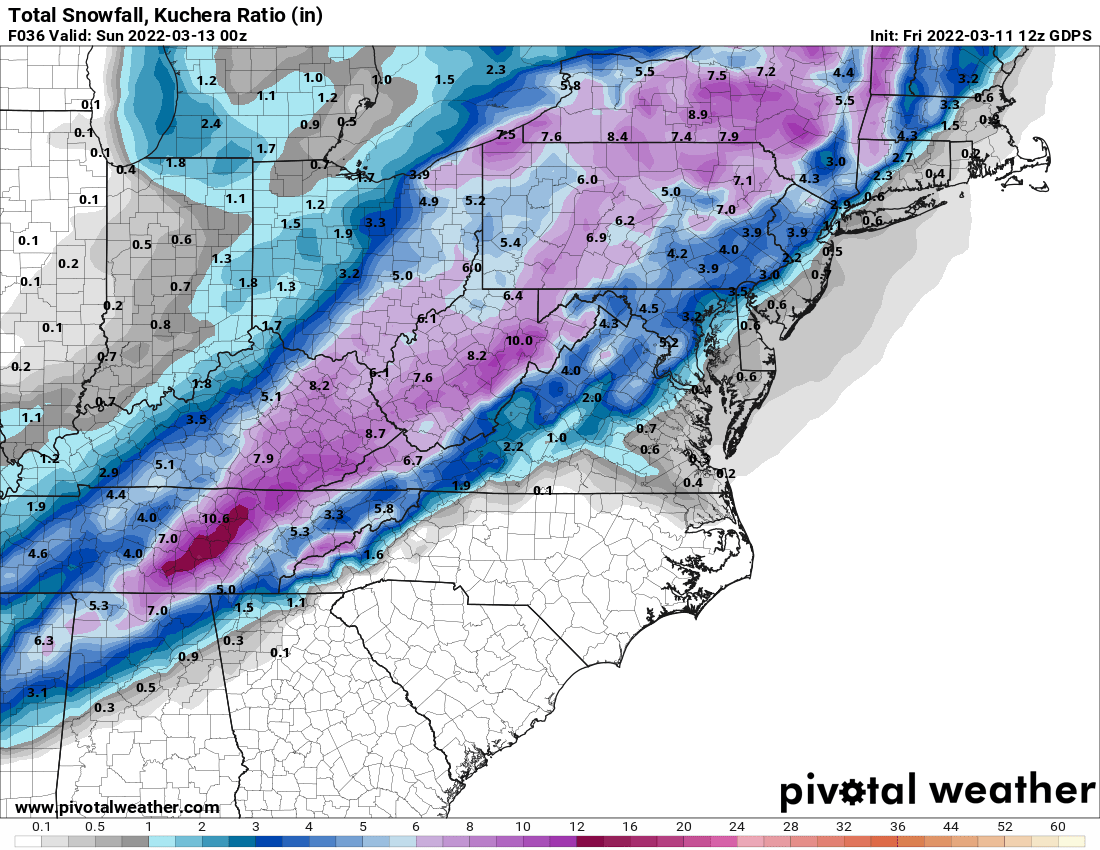
The 1 inch liquid zone on CMC would probably be the best dynamics and thats the zone I was just talking about with the best chance of a surprise, interestingly enough that zone goes right through Snowman19. https://www.pivotalweather.com/model.php?m=gdps&p=qpf_024h&rh=2022031112&fh=36&r=us_ma&dpdt=&mc=
-
Honestly this could go either way, a small shift in track and a 1-2 hour difference in changeover could mean less than 1 inch vs 3. Of course lean low NYC Metro and Southern LI anytime it's a March storm. I'd say HV North and West of the Tappan Zee probably pretty good shape for at least 3-6. The wildcard area probably Northern LI/Immediate NW of the city.
-
I wouldn't expect much accumulation but could see blizzard conditions in NYC Metro for a short period right after the changeover, the dynamics will be intense.
-
Expect some rain but no frozen precip threat at that time.
-
It will snow for several hours probably but the good stuff so to speak which the coast really needs for accumulation in March will probably only be a 1-2 hour window sometime tomorrow between noon and 2.
-
NAM has support lol but I know this isn't the model you trust either

-
Thats why it's kind of odd the HRRR and RGEM are so far apart, those are the mesos that have done best all winter.
-
Yes I think WWA would be extended to all of Westchester and NE NJ after the 12z suite
-
I'm sure somehow LI especially north shore will way overperform the city with this but agree the best chance for more significant snow (>3 inches) would be North and West of the Tappan Zee.
-
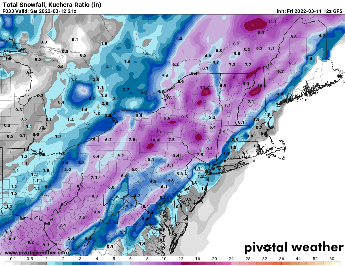
It's interesting how 24 hours out the NAM has double the RGEM for your area. NAM has been so fickle all winter. Probably best to go with an RGEM/CMC/Euro/HRRR blend at this point.
-
Models kind of all over the place still, obviously NW will be better with this than SE although dynamics could make for a wild few hours near or even in the city.
-
HRRRR looks like Euro, Both NAMs still warm with the main show although 3K has a second wave later in the day that brings a little snow.
-
If the low is in that spot it will be that cold, it's way east of any other model right now.
-
It might not snow near NYC but I find it interesting you are conveniently leaving out the top 3 ranked models.
-
Agree I mean well inland can still snow into late March/April, I know people say pattern this, winter over etc but who knows what could pop up for them still. Also I still think Euro is too dry and factoring in ratios most of upstate NY and NE will do well with this, maybe there will be less snow west of Syracuse.
-
Every model has trended toward the Euro and the Euro just keeps trending east, Euro is either going to regain respect with this storm or it can be thrown in the garbage.
-
I wouldn't get too caught up with the OP Euro, the CMC is still throwing very heavy snow back into the catskills and Central NYS, the track is obviously further west of the Euro but not by that much.

-
Every storm this winter has been wetter than modeled and also the CMC which has become sort of the go to model has almost double the qpf of the Euro so I wouldn't be too worried yet about not having enough precip with this. I'd still be way more concerned about the rain/snow line reaching the coast than this being too dry.
-
A low bombing from 996 to 972 in 12 hours isn't really strung out a crap, I think the Euro might be underdoing the qpf a bit and also it's unfortunate this storm is moving so fast. It goes from the Carolinas to east of Maine in 12 hours but it's certainly not weak.
-
This won't be an I95 snowstorm because the airmass is too poor and the storm is too fast, even the Euro which basically has a track barely inside the BM is rain to snow for the coast and if it goes any further east it will be even weaker and more progressive and less precip. Either way I'd be thrilled with even rain changing to 1-3 inches compared to the way things were looking 24 hours ago.
-
I said yesterday for things to be interesting we'd need a way east trend to account for the typical last minute NW trend. We have now gotten the way east trend. There is now a little wiggle room for interior parts of the subforum. For NYC and southeast it's still basically going to take a miracle to see more than an inch or two.