
jjwxman
-
Posts
343 -
Joined
-
Last visited
Content Type
Profiles
Blogs
Forums
American Weather
Media Demo
Store
Gallery
Posts posted by jjwxman
-
-
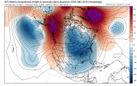
FWIW: The 6Z GEFS MSLP Anomaly doesn't jive with the OP. More Miller A-like.

-
 2
2
-
-
Pivotal Weather has a better simulation than TT (and snow maps). It just light precip, based on the sounding it should be a rain snow mix in GSO at hour 36.

-
NAM definitely trended south with the higher snowfall totals since 18z yesterday. Here's Thursday's 18z and this morning's 06z run.


-
Just now, wncsnow said:
Freezing rain

Wow! That’s approaching Dec. 2002 type of Ice Storm. All in all, this run was colder than the 18z. More snow in the Piedmont this run. Verbatim the Triad got 2-3” Kuchera on the 18z Run, on the 00z run the Triad got 5-6” of snow before the switch. So maybe slowly the NAM is begining to adjust cooler. Fingers crossed.
-
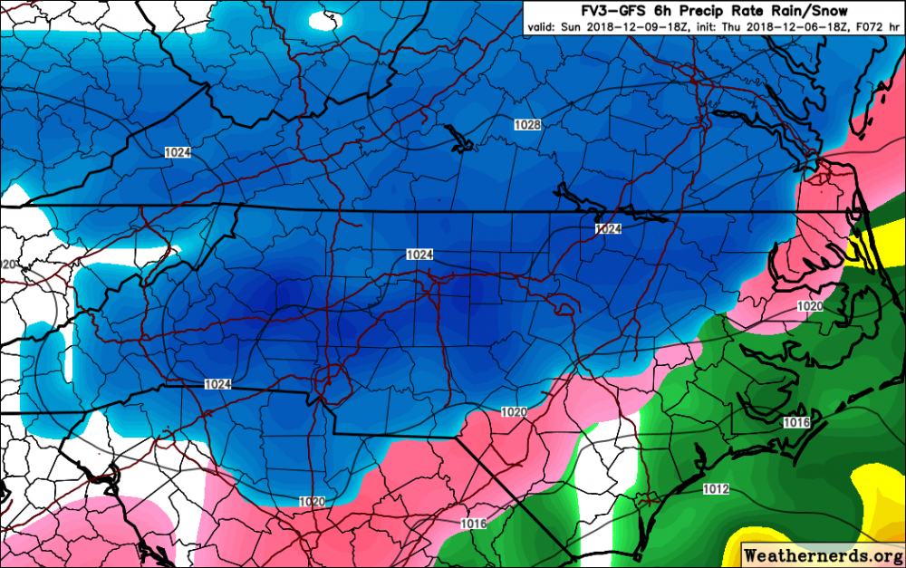
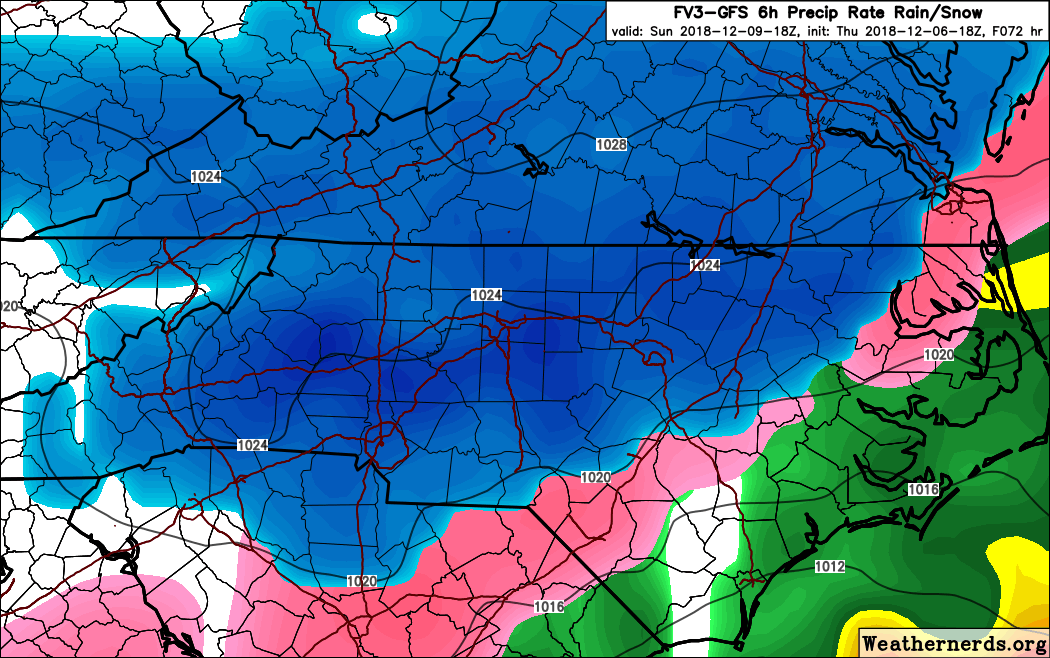
18z FV3, hr 72.

-
8
-
-
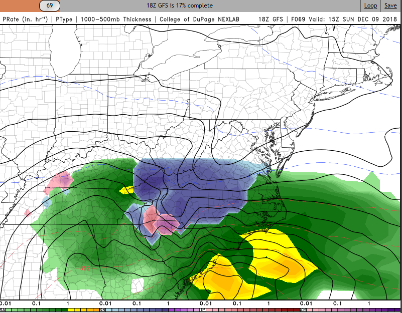
GFS 69:
-
2
-
-
4 minutes ago, Poimen said:
“Major Winter Storm”
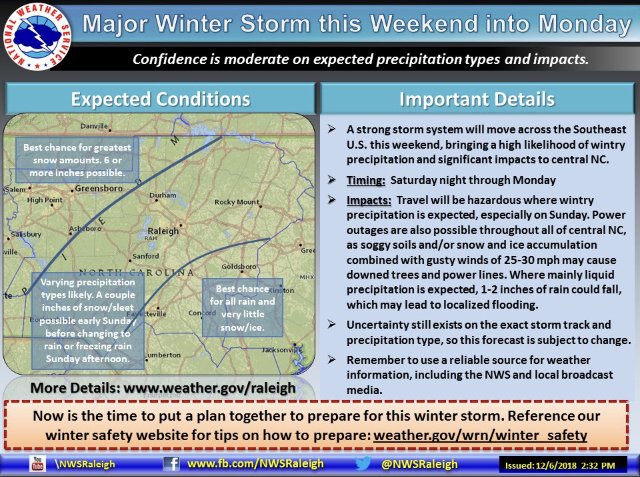
Here we go! RAH is on board. 6+" for the Triad is a good starting point right now. Should see some WS Watches coming within 12-24 hours.
-
18 minutes ago, sarcean said:
Think you might be under estimating the Triad (Greensboro/Winston Salem). I wouldn't group it in the same as Raleigh.
But we will see!
Stokes County 2-4 and Surry County gets 12-24. Now that would be one crazy cut off!
-
Geez... The FV3 looks AWESOME. But the 12z NAM definitely took the air out of the room. #NAM'd
-
Who blames RAH for being too conservative now? Even if the 12z NAM was a crap run, and the 18z comes in super cold, this is why Nick P and the Raleigh forecasting team is waiting to pull the trigger. Good job guys.
-
5
-
-
My thoughts this morning: To much focus on snow maps, not enough focus on who is going to be with out power for 2 weeks because of an inch of ice accrual.
-
5
-
-
28 minutes ago, magpiemaniac said:
RAH’s uncertainty line has moved west overnight.
4:00 PM graphic on Wednesday

5:00 AM graphic on Thursday
 19 minutes ago, PackWxMan said:
Let’s not overreact here
This is a very complex storm system and many players are involved as we all know. When there are uncertainties involved, RAH always errs heavily on the conservative side of caution. With that said, I think that if the models hold through 12z today or 00z Friday you will see them change there wording to a more serious tone. RAH does a great job, they will jump on board soon.
-
1
-
-
Safe to say RAH is on a different planet. I don’t understand.
Regardless of p-type, liquid
equivalents could range from three-quarters of an inch NE to around
an inch SW.
And this:
-
2 minutes ago, Solak said:
RAH:
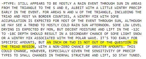
Sat through Mon night: A significant wintertime storm for NC is
growing more likely with every model run. Differences among the
models regarding timing, track, precip amounts, and the vertical
thermal structure and advection patterns persist, which makes any
details still difficult to pin down. But the chance of at least some
wintry precip over the central NC forecast area with this event is
growing.

-Synopsis: A potent mid-upper trough/low will cross the S Plains,
Gulf States, and Southeast during this period, as a surface low
tracks along the Gulf coast/S GA/FL Panhandle, likely evolving into
a Miller B configuration as this energy transfers to a deepening low
just off the Carolinas late Sun. This low should then intensify as
it tracks NE just off the NC coast through Mon. A second, strong
polar stream wave will dive through the Midwest Sat night through
Sun night and into the southern stream wave, prolonging the lift
over central NC as the column cools further.

-Timing: Following the slower ECMWF/Canadian/NAM solution over the
faster GFS, the heaviest precip is expected to fall from early
morning to late afternoon on Sun, in conjunction with strong upper
divergence and mid level DPVA. After this time, drying aloft and
waning forcing for ascent should mean a trend to lower precip rates.

-Ptype: Still appears to be mostly a rain event through Sun in areas
from the Triangle to the S and E, albeit with a little wintry precip
early in the event. For areas N and W of the Triangle, including the
Triad and most VA border counties, a wintry mix with some
accumulation is expected for most of the event through Sun, although
we may see a trend to mostly cold rain Sun afternoon. Some low level
drying is expected by Mon, but decent moisture and lift in the -12C
to -18C depth should result in a secondary chance of some light snow
or a wintry mix associated with the polar wave. It's too early for
specific amounts, but an inch or two is not out of the question in
the Triad region, with a non-zero chance of greater amounts. This
could change, however, especially given the sensitivity of precip
types to small changes in thermal structure and lift, so stay tuned.

-Temps: Expect highs in the upper 30s to mid 40s Sat and Mon, with
low 30s to upper 40s on Sun. Again, this is all predicated on
getting enough warm air into central NC to allow surface temps to
trend above freezing over the forecast area. Lows in the 30s.
They favored the GFS on the 3am discussion. Lol.
-
Just now, Orangeburgwx said:
What the hell...
78: HP jumps back into Wisconsin, LP further inland over Louisiana
850's are better though than the 6z at this point.
-
9 minutes ago, nchighcountrywx said:
Watch your Buffkit data....
The lines are already being drawn.
As of the morning runs:
GSO, INT, HKY snow.
All other sites to the South and East.. no snow (RDU, CLT) with transition line somewhere in between those areas.
I'm 15 miles south of Greensboro, I have already prepared myself for a sleet fest. Just like in the January 2017 storm. In Randleman we had 4-5" of snow/sleet. In Pleasant Garden, 10 miles to my north they had 10-11" of all snow. Preparing myself for a similar outcome.

-
1
-
-
Just now, burrel2 said:
Confluence on the new nam over new england is the best it's looked yet. It delays the high pressure building a little compared to last run, but leaves more cold air to work with overall.
The last thing we want is the high to scoot eastward to quickly, so this is good.
-
1
-
-
1 minute ago, Cheeznado said:
Since here in ATL we will just get a nasty cold rain, I plan to travel up to the AVL area, the ensembles have been incredibly consistent with some very hefty totals, check out the 06Z ensembles- 14 members with 20" or more.
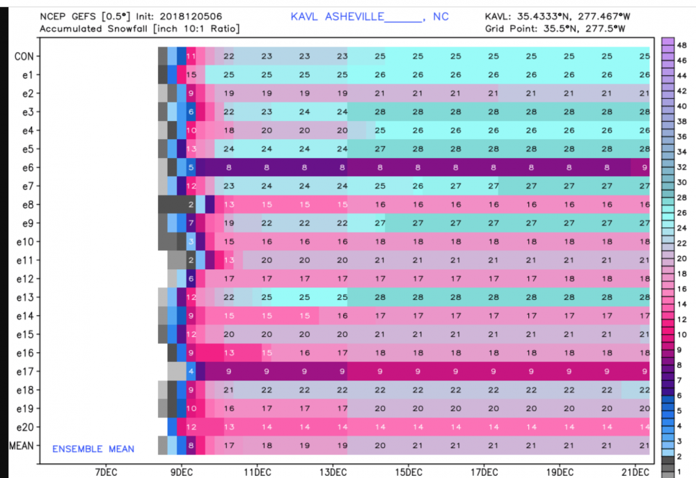
That is just insane, I don't know if I've ever seen an Ensemble Mean like that anywhere in NC. Be careful up there.
-
7 minutes ago, Queencitywx said:
Looking at the 6z NAM, we're clouded over here before Saturday even begins. The more we can limit sunlight that day, the better. With CAD already starting from the high, that could mean temperatures are cooler on Saturday and thus you get a lower wet bulb that evening or night.
Per the 6z NAM the wet bulb temps were generally in the low to mid 20's across a big portion of NC, with low 20's in the North and West Piedmont and Foothills, upper teens in the far NW Mountains.
-
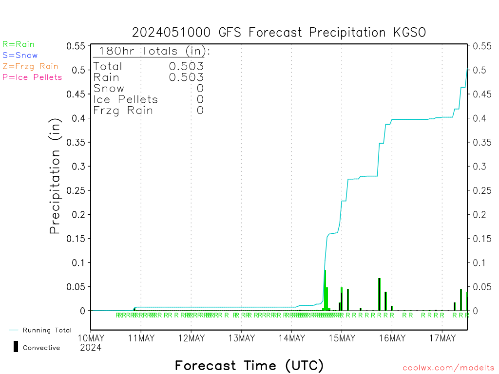
Not sure how accurate this output is from coolwx.com, but if no sleet were to mix in, in GSO like this image depicts below, this could be the outcome. But I'm pretty sure sleet will be factor in GSO.
-
18z GFS: You know where TT has rain, weathernerds.org is mixed, especially the I-85 corridor.
-
Can someone post the 12z Euro QPF Final ? Thanks.
-
FWIW, the 12z GEFS snowfall mean went down from the 06z.
-
 1
1
-
-
1 minute ago, griteater said:
WPC's morning update


It doesn't get more textbook than that. What a Beaut!
-
1
-


Mid to Long Term Discussion 2019
in Southeastern States
Posted
It's now the "old" GFS. Let's see what the FV3 has to offer. Out with the old in with the new right? Heh...