
dailylurker
-
Posts
4,764 -
Joined
-
Last visited
Content Type
Profiles
Blogs
Forums
American Weather
Media Demo
Store
Gallery
Everything posted by dailylurker
-
Is it me or does it seem like the 90's was full of mix events and sneaky warm noses that flipped snow events unpredictability to sleet. Even the blizzard of 96 had about 6-8 hours of sleet and drizzle here (not complaining) I also remember Carroll County always being the jack due to less mixing there. It seems like now when we occasionally do get snow it's a cleaner systems. I rather have fewer events that are clean then a bunch of mix garbage events. I wonder why? And where did clippers go?
-
Yeah. Until the 60 degree snow eating fog showed up a few days later and ate up the snow lol. 23 for a low
-
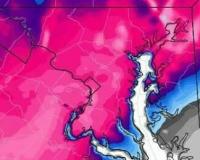
Has a storm like that ever happened? Salisbury with a casual 3 feet while Annopoils gets a few pitty inches lol. Just looked. The biggest snowfall in history for Salisbury is 21". It's crazy how models are always showing completely non climo events in the LR.
-
Snow here and rain in upstate NY. Yeah.. I'd toss that lol
-
I take back what I said earlier about a bust. It's getting dark like a severe thunderstorm is coming. That line looks impressive on radar as it barrels across PG county.
-
Same here. Nothing at all from the line. Basically another bust here so far. Radar looks lackluster. Mostly just sprinkles and light showers.
-
Finally getting some decent rain. Most of the night it was just sprinkles and drizzle. Looks like a classic rainy day ahead. It's a beautiful thing.
-
I appreciate the rain updates. I actually started a thread a couple years ago for tracking winter rain. I find rain interesting so please don't discouraged anyone from posting anything weather related. The GFS looks like it took our Sunday rain away or decreased it as the storm tracks to our NW. It has a heavy band of snow move across the area north of 70 tomorrow night.
-
My point and click has it after 3pm today. Who knows. It's probably drying up on approach lol
-
It's going to snow on Christmas day. It's will be remembered as CD1 420
-
Completely clear here. I can't even see the clouds to the NW that are producing snow flurries. Interesting
-
Does anyone know if the Catoctins got anything this morning?
-
Living in AA County use to be the pits. Everyone nw of me would always get snow while I got rain. Now it doesn't matter anymore. We all suck lol 42 and waiting on anything interesting. I guess I'll take wind. Jesus winter is boring now lol
-
Looks like the Catoctins are about to get a dusting. I thought about hiking up there today. Wind gust to 60 and cold temps sound fun. 42 with a few sprinkles here earlier.
-
Bacon Ridge, Crownsville. Shhhhhhh..
-
Dark, cloudy, 39 degrees. Beautiful December afternoon. I'm headed out for a short, stoner hike. Instead of walking a dog. I walk with a joint lol
-
I don't know about wet but warm is definitely coming lol. Coldest morning of the winter? 20
-
Everyone here is kinda weird. It's my kinda people lol. PSU is a vampire that feeds off snowflakes. Dude never sleeps. He just studies computer models all night. He's extremely valuable so be nice!
-
January 25, 2000 was one of my favorite storms. Only 22" but it fell in like 14 hours. The rates were like being in a very intense lake effect snow band. I recorded over 4" in one hour along with really weird darkness like a thunderstorm. Very wild event.
-
The big dump. The blizzard was a bust here. That week was wild. I ended up with almost 3 feet on the ground. I received 28.5" tieing the Nickerbocker storm. Then I received about 4" from the blizzard a few days later.
-
Personally I think Feb 2010 was the GOAT storm for AA County.
-
Same. I'm staying within a few hours drive. Except in January. I'm eying Lake Placid. My family use to go there when I was a kid. I love that area.
-
23 here in the South River watershed. RIP ticks and mosquitoes. That should do it. 31-32 just isn't enough to shut them down.
-
I bet it's cold up on top of the Catoctins. I wonder if their will be any whitening of the ground up there from these snow showers. I'm seeing some fuzzy snow clouds to my west here in AA County.
-
This is not a deb comment. It's just I've always wondered why models always show these super rare senerios beyond day 10. You think they would show more of a climo look. Not some rare blizzard at Cape Hatteras. We get modeled 200" a year from day 10+. You'd think models would show cutters and warmth as a default. Not 30" of snow on OC lol


