
dailylurker
-
Posts
6,083 -
Joined
-
Last visited


-
Models definitely missed this one. I was expecting any decent rain to stay west of DC today and tonight. It looks like a fire hose aimed at PG and AA county. I was expecting this to be over Frederick this evening
-
Damn. My NAM comment from earlier didn't age well lol. Radar looks amazing right now. Looks at that fetch of moisture.
-
True. It basically never has anything prior to an event. It certainly feels juicy out here.
-
The NAM says what rain today or tonight for DC and east. The storm to the west just goes north and hits the same ole flooded areas of NY.
-
Congrats to the west. It looks like a steady stream of heavy rain along the Blue Ridge. It's been since January since I've seen a juicy radar. Unfortunately that was sleet and 19 degrees lol
-
March first. My typo lol. It's an Airbnb. I'm just taking it for the entire winter. It's got the best location I've found out there. It's right near the famous snow town of Montague.
-
I'm pretty excited for winter. I'm one phone call away from closing a deal on a seasonal cabin rental at Barns Corner, NY. That's ground 0 on the Tug Hill. It's from Dec 1 to February 31. If my location isn't being hit directly I'll still be able to quickly get right where I'll need to be from base camp on the top of the hill. I won't be far from the Adirondacks if I need to get even higher up in elevation. Pretty exciting times.
-
I'd have them replace all the boards. You're place is beautiful. The reason I say this is because you need a non film forming woodstain (oil). These types of stain showcase the natural beauty of wood. New boards and old boards will have different levels of checking and coloration. You are correct about letting the wood dry. I like 13% or less on my moisture meter. That takes about 6 weeks this time of year. I'd wait 8 since your in the shade. Let's setup a free estimate sometime soon. We'll schedule it up for Oct. I have tons of experience and fair pricing. It's a little more humid this morning. I'm seeing lots of dew. I wanted to start staining at 7am but it's to damp this morning. What an awesome airmass we just had.
-
I'm going to be washing a house on Sunday at 11 right near your town. I'd love to come by and take a look. I've been restoring deck since 1997. I definitely have a few options. Send me a DM. It was super nice out today. It was a lovely day to be outside.
-
I work outside. (I've got some great fall specials on softwashing, deck restoration, paver restoration and more. Support my winter snow chases by hiring me. You'll receive my personal chase footage during this upcoming season). This weather is awesome. It's making up for the smoky hell we had during early July.
-
Boring. Hopefully a cat 3 comes up the bay in September bringing a tornado swarm and big river flooding to make up for this historically boring pattern we've been stuck in since sleet fest in January.
-

2026 Mid-Atlantic Severe Storm General Discussion
dailylurker replied to Kmlwx's topic in Mid Atlantic
Glen Burnie gets the golden thunderstorm award for the season. That area gets hit every single time there's a chance of a thunderstorm. If there's a chance for severe that's where it always happens. Frederick is in second place lol- 1,710 replies
-
- 1
-

-
- severe
- thunderstorms
- (and 7 more)
-
Today looks like a good day to use my bosses card and take off while everything dries out. Anyone want to join me!? I'm going to do at least 10 miles. I'll tell you about the 6 times in my life that was i was indirectly struck by lightning. Or how about a Tug Hill story where I jebwalked in 8 feet of snow that fell on me in 5 days. I even have a hurricane Gloria story from when I was a kid. LFG!
-
2026 Mid-Atlantic Severe Storm General Discussion
dailylurker replied to Kmlwx's topic in Mid Atlantic
I just had some big gust blowing through. I could hear trees breaking and branches falling. Not much thunder and the rain has been kinda underwhelming. Classic stormy summer evening.- 1,710 replies
-
- 2
-

-
- severe
- thunderstorms
- (and 7 more)
-
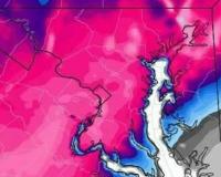
2026 Mid-Atlantic Severe Storm General Discussion
dailylurker replied to Kmlwx's topic in Mid Atlantic
Best radar I've seen in a long time for my area, and most of the metro area. LFG!

