WeatherFox
-
Posts
1,455 -
Joined
-
Last visited
Everything posted by WeatherFox
-
Area Forecast Discussion National Weather Service New York NY 1035 PM EST Sat Dec 11 2021 .SYNOPSIS... A cold front pushes quickly offshore tonight. High pressure builds in on Sunday.. && .NEAR TERM /UNTIL 6 AM SUNDAY MORNING/... Cold front and line of showers have passed east of NYC metro as of 0230z. The line has actually weakened over the last hour with gusts largely below 40 kt. The line appears to be heading into an environment less conducive to any strengthening. There still could be a few gusts 40-45 kt right behind the frontal passage due to increased mixing for a brief time. Model soundings then indicate wind gusts should largely stay 30-35 kt overall. Have left the wind advisory in place for now, but downstream obs do not support it going until 4 am.
-
Ya, the cold front passed through. That’s good for the NYC AREA that severe weather did not occur.
-
https://www.spc.noaa.gov/exper/mesoanalysis/new/viewsector.php?sector=16
-
http://www.meteo.psu.edu/fxg1/WXTYPE/loop25ne.html
-
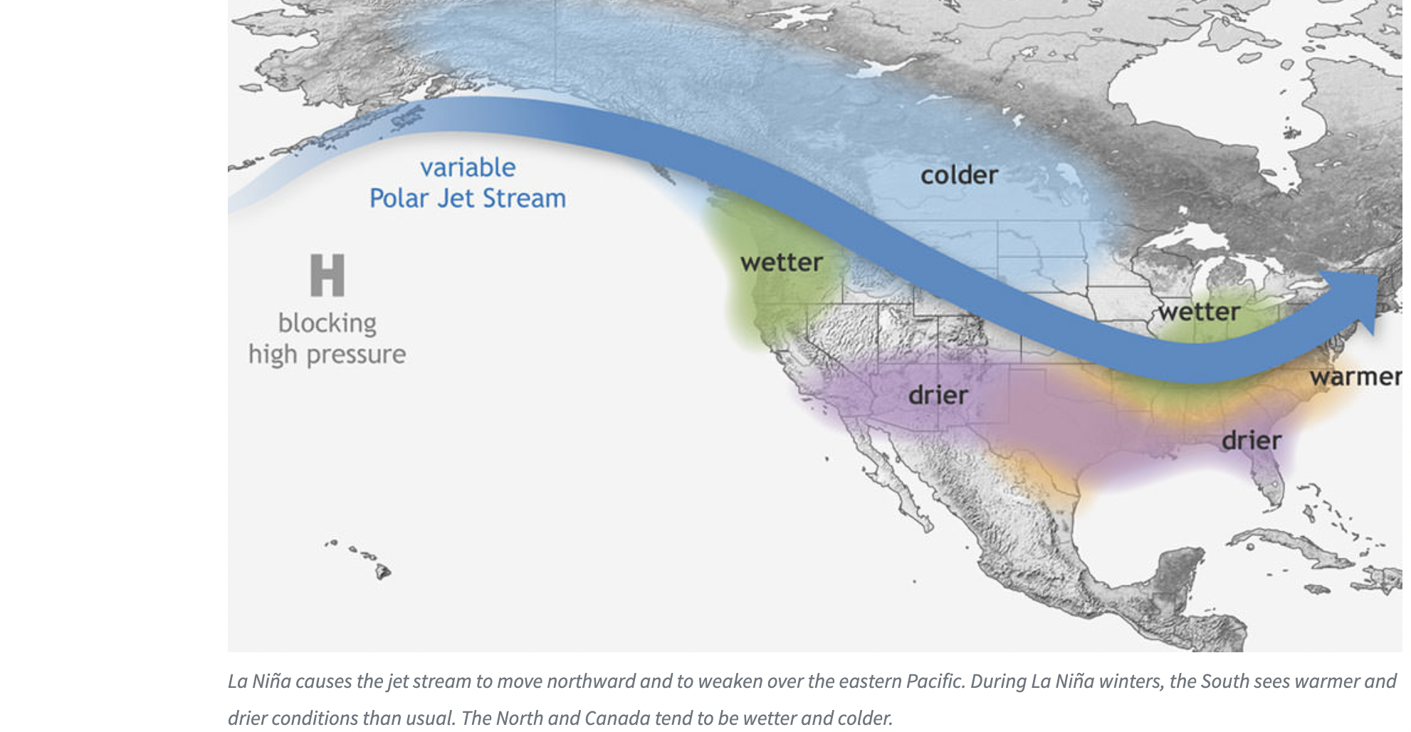
La Niña graphic for northeast weather. Unfortunately, not conducive to snow in the NYC area at this time. You can hope things change in time, this winter..

-
Move to Florida guys. The weather is beautiful here and you can see snow on your TV..
-
Until 1015 PM EST. * At 925 PM EST, showers producing damaging winds were located along a line extending from 10 miles south of Branford to near Captree State Park, moving east at 55 mph. HAZARD...60 mph wind gusts. SOURCE...Radar indicated. IMPACT...Expect damage to trees and power lines. * Locations impacted include... Islip, Riverhead, Centereach, Shirley, Medford, Southold, Hauppauge, Ronkonkoma, Manorville, Stony Brook, Patchogue, Middle Island, Port Jefferson, Wading River and Center Moriches.
-
OKX issues Severe Thunderstorm Warning for Suffolk [NY] till 10:15 PM EST nwschat.weather.gov/vtec/#2021-O-N…
-
Area Forecast Discussion National Weather Service New York NY 954 AM EST Mon Dec 6 2021 .SYNOPSIS... A strong cold frontal passage occurs this evening. High pressure will then build in from the west on Tuesday, followed by a fast moving low passing to the south and east on Wednesday. High pressure will then return Wednesday night into Thursday..
-
Lets see what the 00Z runs show.
-
Progressive pattern for this low which is modeled weak and a fast out to sea south of the NYC forecast area.
-
The WPC prog show weak lows southeast of the 40N/70W benchmark. NYC folks might see some light wet snow on Wednesday and Wednesday night.

-
-
Ya, those are the computer models. Will just need to have Fred reform, which it was predicted it would.
-
https://nwschat.weather.gov/p.php?pid=202102011907-KOKX-NOUS41-PNSOKX
-
13.3 inches in Central Park as heard on the Weather Channel. Video shows a lull in snow currently.
-
NWS “The Probabilistic Winter Precipitation Forecast (PWPF) graphics have been updated through 72 hours, which is 00z (7pm) Monday evening. The current forecast has advisory level snow across the interior (avg of 3 inches) with near warning level (avg of 6 inches) near the coast. Additional snow is possible Monday night into Tuesday, but amounts are much less certain. There may also be a sharp cut off in amounts somewhere across the region, which at this time looks to be somewhere across the interior. If the low tracks a bit closer to the coast, then the northward extent will move further inland and amounts there will be increased. This could also introduce potential of mixing with rain on eastern Long Island. A track further south and east would mean less snow across the board. These details will be hopefully fine tuned through the weekend. Our official forecast keeps the precipitation snow with the surface low and mid level low centers all passing south of the region. These are favorable tracks to keep a more northerly flow holding any warming off the ocean down until precip rates decrease or if there is any dry slot. Again this looks like a concern for only portions of Long Island at this time. Looking at probabilities from the GEFS and ECMWF EPS, the probability of seeing 6 inches or more has increased for the southern portion of the area in the last 24 hours. The winter storm has the potential to produce a foot of snow somewhere in the CWA. This will all be dependent on mesoscale banding and the track of the system. Strong winds will also be possible, especially across the southern portion of the region. Gusts 35 to 45 mph cannot be ruled out at some point Monday into Monday night.”
-
Potential prolonged NYC snowstorm. Accu-weather initially broadcasting 6-10” for the Big Apple. If trends continue you guys will see a Winter Storm Watch posted followed by.. Sunny and 65 F down in Central Florida but with snow I’d rather be up there! Good luck guys..
- 2,426 replies
-
- 3
-

-
- heavy snow
- ice pellets
- (and 3 more)
-
Be happy to date there was 1 big snowstorm in your region. Be optimistic that another one can materialize..
-
National Weather Service Forecast Offices https://www.weather.gov/srh/nwsoffices?site=tae
-
https://www.ametsoc.org/ams/index.cfm/education-careers/education-program/weather-resources/