WeatherFox
-
Posts
1,455 -
Joined
-
Last visited
Content Type
Profiles
Blogs
Forums
American Weather
Media Demo
Store
Gallery
Everything posted by WeatherFox
-
East of the 40/70 Benchmark at this time.
-
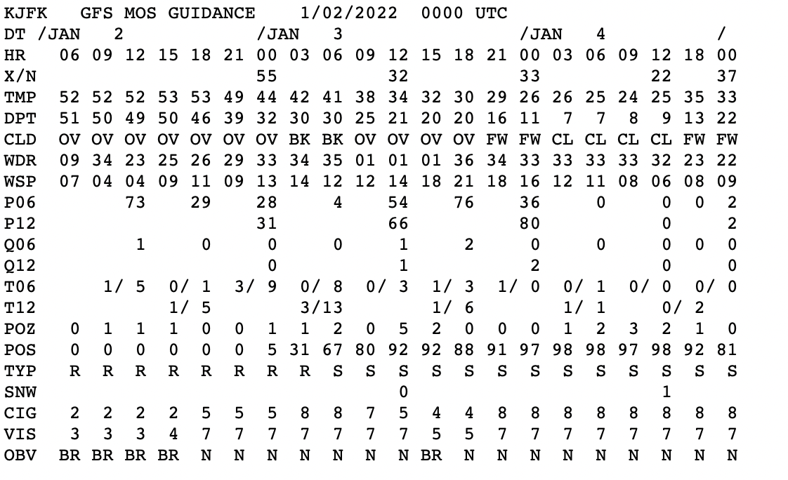
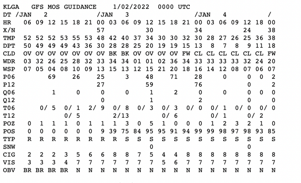
00Z MOS for JFK and LaGuardia Airports in NYC. Light snow indicated..

-
Earlier NWS NYC Forecast Discussion: "This will overall be a minor light snow event. Snowfall totals are expected to be greatest over eastern Long Island, where 1-2 inches are possible. Farther west over northeastern NJ and NYC up to an inch is possible. Snow totals drop off farther north, with the CT coast and southern portions of the Lower Hudson Valley likely seeing less than an inch and far northern locations staying dry. Trends in track will need to be monitored given the nature of the tight gradient in QPF and snowfall. Timing of the event may be the biggest concern. Snow starts in the early morning hours on Monday and will continue through the evening. This could impact the morning commute and potentially the evening commute for eastern Long Island. With temperatures dropping quickly overnight tonight to below freezing, snow is expected to stick right away. Given the uncertainty that surrounds this system, and current light snowfall totals, have decided to hold off on any headlines over our area in collaboration with neighboring offices. Subsequent shifts will have to monitor new guidance and a Winter Weather Advisory may be possible for eastern Long Island.."
-
Advisory creeping close to the NYC area: Winter Weather Advisory URGENT - WINTER WEATHER MESSAGE National Weather Service Mount Holly NJ 906 PM EST Sun Jan 2 2022 DEZ001-NJZ013-014-016>019-PAZ070-071-031500- /O.CON.KPHI.WW.Y.0001.220103T0900Z-220103T2100Z/ New Castle-Western Monmouth-Eastern Monmouth-Salem-Gloucester- Camden-Northwestern Burlington-Delaware-Philadelphia- Including the cities of Wilmington, Freehold, Sandy Hook, Pennsville, Glassboro, Camden, Cherry Hill, Moorestown, Mount Holly, Media, and Philadelphia 906 PM EST Sun Jan 2 2022 ...WINTER WEATHER ADVISORY REMAINS IN EFFECT FROM 4 AM TO 4 PM EST MONDAY... * WHAT...Snow is expected. Total snow accumulations of 1 to 3 inches. * WHERE...Parts of central and southwestern New Jersey, far southeastern Pennsylvania and northern Delaware. * WHEN...From 4:00 AM until 4:00 PM Monday. * IMPACTS...Plan on slippery road conditions. The hazardous conditions could impact the morning commute. PRECAUTIONARY/PREPAREDNESS ACTIONS... Slow down and use extra caution while driving.
-
I’ve been around a long time. This could be the “surprise” snowstorm or the disappointing one. We are always concerned about warmer air changeover of a potential snowstorm to sleet, rain amongst other things..
-
NWS NYC did.. The forecast area will be on the northern fringes of the low, there is a large precipitation gradient and a track closer to the coast could lead to more in the way of snow if further model runs show a continued northward jog. At this time, the thinking is for less than an inch for portions of northeast New Jersey, Lower Hudson Valley, southern Connecticut and western Long Island, while 1 to 2 inches is expected across central and easter Long Island and southeastern Connecticut. Northern portions of the Lower Hudson Valley and inland southwestern Connecticut will see little, if any snow. It`s worth noting that a few short range ensemble means bring warning level criteria to southern portions of the forecast area, but did not go that high given aforementioned uncertainty.
-
NWS Mount Holly this morning… This is a rapidly evolving forecast and users should monitor the forecast closely through the course of today as additional changes, potentially significant, are possible.
-
Cold is just 1 of the dots to be connected and your modeling the long range.
-
Congratulations, with 20 years you could retire, but stay around and enjoy the experience.
-
Yes, including a number of zero cities and trace cities..
-
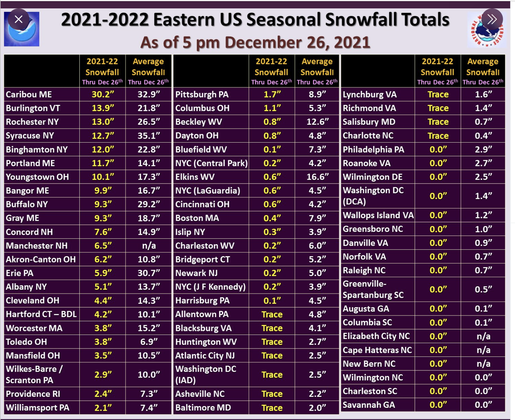
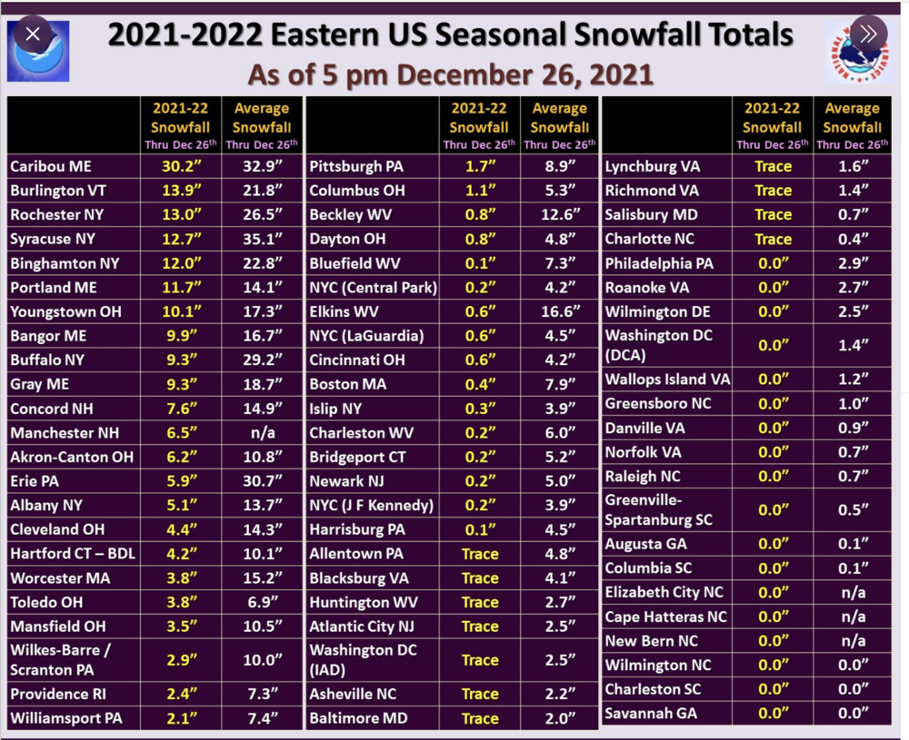
NWS Eastern Region @NWSEastern "A look at how far below average the seasonal snowfall totals are running at Eastern US climate locations as of December 26th." 5 more days to make some revisions!
-
Agree. When it's this far out there is no certainty to the forecast. It's just something to keep an eye on. We know that even short range forecasts are not always certain.
-
Ya, that's a possible long range snowstorm for folks in Maine.
-
Here are the accumulation reports: https://forecast.weather.gov/product.php?site=NWS&issuedby=OKX&product=PNS
-
Snowfall accumulation reports: https://forecast.weather.gov/product.php?site=NWS&issuedby=OKX&product=PNS
-
From the NWS Pittsburgh, PA The official definition of a "White Christmas" is at least 1 inch of snow on the ground (snow depth) at 7 a.m. Christmas morning, December 25th. ❄️
-
Regional Weather Roundup National Weather Service New York NY 400 AM EST FRI DEC 24 2021 Note: "FAIR" indicates few or no clouds below 12,000 feet with no significant weather and/or obstructions to visibility. NYZ071-072-176-178-NJZ106-104-241000- New York City Metro Area CITY SKY/WX TMP DP RH WIND PRES REMARKS Central Park FLURRIES 30 27 88 CALM 30.14F World Trd Ctr NOT AVBL Bronx Lehman C N/A 32 30 93 SE5 N/A WCI 27 LaGuardia Arpt FLURRIES 31 26 82 SE7 30.12F WCI 24 Queens College N/A 32 30 93 SE7 N/A WCI 26 Kennedy Intl LGT SNOW 30 27 86 SE7 30.14F FOG WCI 23 Breezy Point N/A 34 N/A N/A E5 N/A WCI 30 Brooklyn Coll N/A 32 28 86 E6 N/A WCI 26 Staten Island N/A 32 28 86 E3 N/A Newark/Liberty FLURRIES 33 27 78 SE3 30.13F Teterboro LGT SNOW 30 25 81 S3 30.12F $$
-
wdrag nailed this! Special Weather Statement National Weather Service New York NY 326 AM EST Fri Dec 24 2021 CTZ005>012-NJZ002-004-006-103>108-NYZ067>075-078>081-176>179- 241400- Northern Fairfield-Northern New Haven-Northern Middlesex- Northern New London-Southern Fairfield-Southern New Haven- Southern Middlesex-Southern New London-Western Passaic- Eastern Passaic-Hudson-Western Bergen-Eastern Bergen- Western Essex-Eastern Essex-Western Union-Eastern Union-Orange- Putnam-Rockland-Northern Westchester-Southern Westchester- New York (Manhattan)-Bronx-Richmond (Staten Island)- Kings (Brooklyn)-Northwest Suffolk-Northeast Suffolk- Southwest Suffolk-Southeast Suffolk-Northern Queens- Northern Nassau-Southern Queens-Southern Nassau- 326 AM EST Fri Dec 24 2021 Light snow is beginning to fall across the region and should continue through day break. A light coating of accumulation is expected on area roadways, especially secondaries and untreated roads. Temperatures are also below freezing which could create slick spots where snow may have initially melted. Use extra caution if traveling early this morning as slippery conditions are expected.
-
Would be nice to see some snow but its six day's away, many more runs, model comparisons and temps in the 40's would make for rain showers.
-
Current reality in next 7 days for NYC. Progressive pattern, lack of enough cold air, unlikely phasing, and no White Christmas. Today Partly sunny, with a high near 43. Breezy, with a northwest wind 16 to 20 mph. Tonight Mostly clear, with a low around 27. Wind chill values between 20 and 25. North wind 8 to 17 mph. Monday Sunny, with a high near 39. Wind chill values between 15 and 25. North wind 5 to 10 mph becoming south in the afternoon. Monday Night Mostly clear, with a low around 33. Southwest wind 8 to 10 mph. Tuesday Sunny, with a high near 46. West wind 6 to 9 mph becoming east in the afternoon. Tuesday Night Mostly clear, with a low around 35. Wednesday Mostly sunny, with a high near 48. Wednesday Night Partly cloudy, with a low around 31. Thursday Mostly sunny, with a high near 42. Thursday Night Mostly cloudy, with a low around 34. Friday Partly sunny, with a high near 47. Friday Night Mostly cloudy, with a low around 37. Christmas Day Partly sunny, with a high near 48.
-
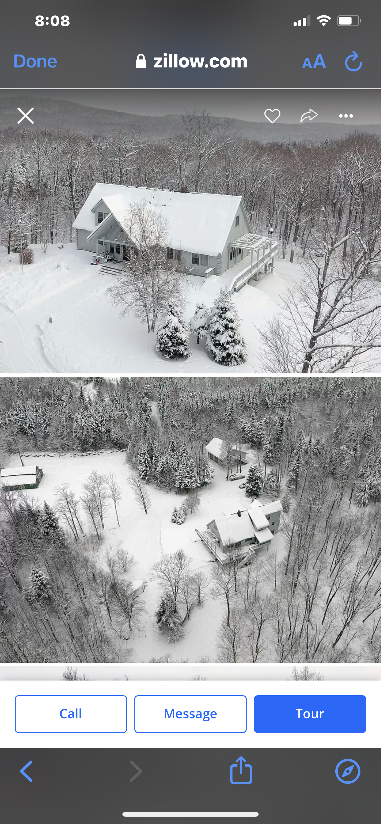
A house in Vermont for snow lovers!

-
Better yet, retire and move to Florida and track canes. After a while SNOW gets old.
-
Let’s go Canada!
-
NEG NAO Posted 47 minutes ago Until the Euro and GFS ensembles comes on board and we get several runs in a row of consistency confidence will increase IMO Agree!
-
Fyi “La Niña is anticipated to affect temperature and precipitation across the United States during the upcoming months (the 3-month seasonal temperature and precipitation outlooks will be updated on Thurs. Dec. 16th) by NOAA”