

CAPE
-
Posts
33,534 -
Joined
-
Last visited
Content Type
Profiles
Blogs
Forums
American Weather
Media Demo
Store
Gallery
Everything posted by CAPE
-
Wind is cranking here on the SW side of the departing ridge with lower pressure/front approaching from the south. Gusting to 30 mph. Feels nice outside though, and no rain at all. Had some sun until the past hour.
-
Warm season NA blocking Can't wait for the models to tease with advertised blocking that never verifies for the winter months. It has become a tradition.
-
Sitting outside on the deck drinking a glass of wine and taking in this perfect fall-like evening. 69 with a dew point of 39. Can't get much better than this in early June.
-
Yeah some of the meso runs had this, but I was skeptical. I am over 7" for May now.
-
Round 2 has arrived. Nothing severe, but looks like there could be some persistent(training?) cells. Torrential rain currently.
-
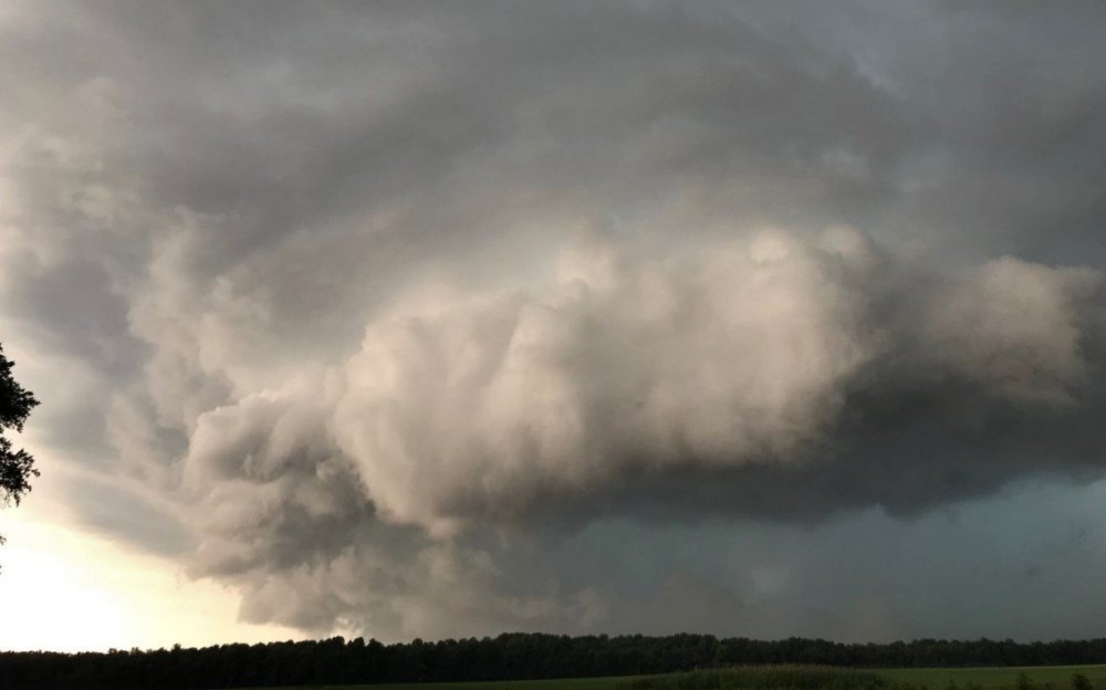
Here is another shot of the same storm a few miles southwest as I was driving.
- 2,802 replies
-
- 6
-

-
- severe
- thunderstorms
- (and 4 more)
-
Damn. At least it wasn't a flood.
-
Total rainfall for the storm here was 0.85". It was going sideways though, so probably more than that fell.
-
Shot of the storm approaching here from the end of my driveway. The rush of wind was impressive on the front end, and the power went out pretty quick. Just came back on after about an hour. Lots of tree debris and branches down but no major damage. Nice storm.
- 2,802 replies
-
- 15
-
-

-
- severe
- thunderstorms
- (and 4 more)
-
Yeah lots of booming thunder here. Picked up 0.65" of rain.
-
Is there a category below garden variety? If so, that's what I had in my yard. Some brief, heavy rain, some T&L(mostly from the better storms to my south), and virtually no wind. Picked up 0.35" of rain though. Has gotten a tad dry here lately.
-
Interesting read from Mount Holly on the severe potential, and limiting factors: Although showers, and possibly a thunderstorm or two, will continue to be possible in the warm sector through the morning, the main round of storms we are concerned about are storms that are expected to develop along and ahead of the pre-frontal trough late Thursday afternoon into Thursday evening. Some of these storms could be severe. Most models depict ML CAPE values near or above 1000 J/kg in the 21 to 00Z time frame along with 0-6km bulk shear values of 40 to 50 kt. Not only is this a significant amount of shear, but model soundings depict plenty of veering with height (especially within the first 3 km). This further enhances the risk that updrafts could be persistent. There are a few potential caveats. First, low/mid level clouds may not erode through the morning. This will limit diurnal heating (in anticipation that this may be the case, have gone with the cooler guidance for highs on Thursday), which would limit instability/CAPE values. Secondly, related to the first caveat, the NAM depicts a low level inversion (around 900 mb) which never fully erodes through the day (unlike the GFS which depicts this eroding between 21 and 00Z). Even if we are cooler and the inversion stays in place, I think we will continue to have at least some severe threat as lift along the trough could be enough to lift elevated parcels above the inversion. The final caveat is that remarkably, model soundings are depicting several dry (and one very dry) layers through the afternoon and evening. This means the LCL will be higher than normal, and will have an impact on the risk for wind, tornado, and heavy rain. Speaking of hazards: Damaging wind: This looks to be the primary hazard thanks to a low and mid level jet, and plenty of shear. The low level inversion mentioned above may limit how efficient the mixing is down to the surface, but the dry levels will help to increase the risk of downbursts thanks to an increased risk of dry air entrainment. Hail: Severe hail (1" in diameter or greater) is certainly possible, especially if we warm up as much as what the GFS is depicting and are able to realize the higher CAPE values. The highest threat for hail looks to be over Delmarva and far SE PA where the highest CAPE values are possible. Tornado: The veering wind profiles increase the risk for rotating updrafts. However, as mentioned above the LCL will be higher than normal which could limit the threat for tornadoes.
-
Mesos depicting some decent FGEN associated with a boundary at 850 mb. Looks like that is where the axis of heaviest rain will set up later tonight. Probably along I-95, and more towards NE MD and SE PA, and into SNJ.
-
Some thunder and drizzle here. Nice storm to my south.
- 2,802 replies
-
- 1
-

-
- severe
- thunderstorms
- (and 4 more)
-
Best part of this event is occuring now. Moderate rain with that low rolling, long duration, house shaking thunder. So cool. Wish I understood the mechanism better. Also wish my subwoofers could rock the house like that lol.
- 2,802 replies
-
- 4
-

-
-
- severe
- thunderstorms
- (and 4 more)
-
Was pretty garden variety here. Heavy rain, some wind, and some T&L. Over an inch of rain today with what fell this morning.
-
Line rapidly approaching here. Wind really picking up and lots of thunder.
- 2,802 replies
-
- 3
-
-
-
- severe
- thunderstorms
- (and 4 more)
-
Get out there and get some pics or a vid! looks like it could be really close to your location.
-
Lots of thunder here. I am west of Easton and its staying mostly just to the east of here.
-
I am in Easton but saw that cell on radar. Looked like it went right over my yard. Stuff is popping already. The hodos on some of the meso models show some decent veering and curvature. Later today should be interesting.
- 2,802 replies
-
- 2
-
-
- severe
- thunderstorms
- (and 4 more)
-
Interesting. I have not paid much attention to this admittedly, with a lot of other stuff going on. Just read the AM AFD from Mount Holly... A surface low in the Midwest will continue northeastward today in advance of a southern-stream vort max that is beginning to phase with a digging northern-stream shortwave trough. Amplification and negative tilting will continue through the morning as the large- scale trough approaches the Appalachians by midday. The Mid-Atlantic will be at the nose of a potent midlevel jet streak/vort max this afternoon, with strongly difluent flow in the upper levels favorable for substantial large-scale ascent along and in advance of a surging cold front. A warm front will lift north through the northern Mid- Atlantic today, with the warm sector likely making it through about the southern two-thirds of the CWA or so by early afternoon. Latest convection-allowing model guidance is suggestive of an environment favorable for organized severe storms this afternoon. Forecast soundings indicate backing surface flow as the large-scale system and associated surface low to our northwest deepens within the warm sector this afternoon. Hodographs are strongly indicative of potential for rotating storms. Low-level storm-relative helicity of 200-300 J/kg is not out of the question in advance of the cold front late this afternoon and this evening. In addition, several of the hi-res models develop decent mixed-layer based instability (with mitigating effects near the colder waters, as usual). The resulting CAPE/shear parameter space is adequate for tornadic supercells, though the strong large-scale ascent may favor more of a quasi- linear convective system (QLCS) with embedded transient/rotating storms.
- 2,802 replies
-
- 1
-
-
- severe
- thunderstorms
- (and 4 more)
-
"Near" is relative. In the context of a very localized event, that was not near me. And I live NW of Greensboro, so its more like 25 miles. Also the tornado was 2.5 miles south of Federalsburg, so now we are pushing 30. But thanks Yoda!
- 2,802 replies
-
- 1
-
-
- severe
- thunderstorms
- (and 4 more)
-
That's pretty far south of me. I am in the northern part of Caroline county, which is pretty expansive north to south. This was the same event that produced the stronger tornadoes in southern DE I believe, and could have been associated with the same localized cell(s)- which would make sense as that location is pretty close (just NW) of the Seaford/Laurel area.
- 2,802 replies
-
- 1
-
-
- severe
- thunderstorms
- (and 4 more)
-
That's pretty cool. He does have a distinctive voice. I miss having a 'muscle car'. Been almost a year since I got rid of my srt8. This 2018 Overland I am leasing is so nice though. Loaded- it does everything lol. Plush interior, great sound system, and the V-6 has plenty of power. Plus 24 mpg hwy and takes regular fuel. That's the part that makes me not miss the srt.
- 2,802 replies
-
- 1
-
-
- severe
- thunderstorms
- (and 4 more)
-
Just over an inch here. Hopefully this is winding down and things start to dry out.

