

CAPE
-
Posts
36,948 -
Joined
-
Last visited
Content Type
Profiles
Blogs
Forums
American Weather
Media Demo
Store
Gallery
Everything posted by CAPE
-
1.7" for the day. Lots of thunder on the back edge. First month above avg since Feb. Just over 6"
- 1,710 replies
-
- 4
-

-

-
- severe
- thunderstorms
- (and 7 more)
-
So far just heavy rain and lots of T&L. Minimal wind. I'm good with it.
- 1,710 replies
-
- 1
-
-
- severe
- thunderstorms
- (and 7 more)
-
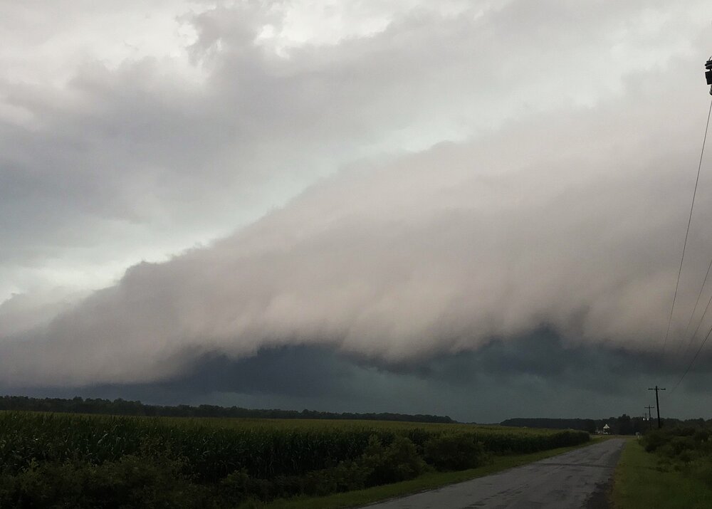
Took a quick shot of it rolling in.
- 1,710 replies
-
- 17
-
-

-

-
- severe
- thunderstorms
- (and 7 more)
-
0.45" in 20 mins from this initial storm. Can already hear the booming thunder from the line to the NW.
- 1,710 replies
-
- 1
-
-
- severe
- thunderstorms
- (and 7 more)
-
Getting hit with heavy rain here. Kind of blossomed just to the SW. Radar looks pretty interesting to the NW for a bit later.
- 1,710 replies
-
- 1
-
-
- severe
- thunderstorms
- (and 7 more)
-
This is BIG. Ravens have the makings of a dominant defense but getting this guy back healthy would be insane and open up more opportunities for some of the younger pass rushers to make an impact.
-
It's fundamentally how he/they evaluate positional talent and draft that's flawed. The Elias way is arrogant- he thinks he has all the answers and needs no input from others with different perspectives. They end up with many similar players that mostly all underachieve. Another major flaw is not properly assessing/drafting top pitching talent. Emphasis is on metrics and not so much on scouting/actual evaluation- the eye test.
-
The Orioles Still Cannot Hit Offspeed Pitches. Mike Elias Is Only Making The Problem Worse The Orioles growing list of failed prospects have too much in common and are symptoms of an organizational disease https://www.si.com/mlb/orioles/onsi/the-orioles-still-cannot-hit-offspeed-pitches-mike-elias-is-only-making-the-problem-worse-01ky8djg6v54?page_source=v_recirc
-
One team is much better than the other. Good teams often find a way to win. Bad teams...
-
Os walk off. Need more of that shit.
-
100+ for Miles City Montana though next Saturday. It's that 'dry' heat though. Currently 105 with a dp of 42
-
Pretty interesting h5 pattern setting up for the US will produce weather extremes. I'll take our area for this one. WPC EFD- ...Weather/Hazards Highlights... Extreme heat will continue to make weather headlines across a large expanse of the country going into next week. Widespread upper 90s and low 100s are expected from Montana to the Dakotas, which is about 10-15 degrees above average. It will also be very hot and humid from Texas to the Gulf Coast states with highs ranging from 95 to 105 degrees on most days, with some areas of extreme HeatRisk given the longevity of the heat and expected heat indices exceeding 110 degrees at times. It will also be quite hot from the Desert Southwest and extending north across the Intermountain West with the upper ridge exerting its influence. Highs in the 110s to 120F in the hottest deserts of southern Arizona/southeastern California will only cool into the upper 80s to mid 90s at night. Farther north, temperatures near 100 degrees will be common over the Great Basin. Over the Northeast/Mid-Atlantic, upper troughing will favor near to below normal temperatures in the generally pleasant 70s/80s during the day and 50s/60s at night. An organized low pressure system crossing the Northeast and Mid- Atlantic region on Tuesday, in combination with an amplifying upper level shortwave trough, will fuel the development of numerous showers and storms from Virginia to New England. A risk of flash flooding is possible in the region Tuesday into Wednesday with a potential for 1 to 2+ inches of rainfall. There is also a threat of severe weather across portions of the Mid-Atlantic in the warm sector of the low pressure system. Damaging winds are the primary hazard with the strongest storms.
-
Looks like 79 is the high for the day. 2 straight days under 80 with dewpoints in the 50s in late July isnt very common in these parts.
-
I had a light shower here. Was planning to get out early and mow whatever crap is growing out there, but just enough wetness that I'll have to wait a bit.
-
Another Orioles special. Their fundamental issues aren't correctable. They are going to lose to the good teams, but there are plenty of mediocre to bad teams on the upcoming schedule too.
-
I am definitely skinny CAPE- relatively modest updrafts but over a vertically deep layer(quite long/tall) and with lots of juice. @ravensrulewill be along shortly
- 1,710 replies
-
- 3
-

-
- severe
- thunderstorms
- (and 7 more)
-
About to pour an Other Half TDH ALL RIIIOT EVERYTHING NZ EDITION to leadoff Friday HH A triple dry hopped Imperial IPA. Hell of a name.
-
High of 78 Currently 77 with a DP of 57 Gimmie this for the next month.
-
Elias needs to go. End of.
-
They sure as hell are due for a loss
-
WB map inundation.
-
^that being said, Elias the gas lighter will probably still buy, and do even more damage to this team going forward.
-
They are who we thought they were. They will probably find a way to blow the second game, with an early 4 run lead and their ace on the mound.


