

40/70 Benchmark
-
Posts
68,963 -
Joined
-
Last visited
Content Type
Profiles
Blogs
Forums
American Weather
Media Demo
Store
Gallery
Posts posted by 40/70 Benchmark
-
-
6 hours ago, WestMichigan said:
Any reason why?
CC.
-
 1
1
-
-
6 hours ago, frd said:
Why not ?
Several mentions online recently that it prevents a raipid strong early season PV development. But, regardless we all know its going to be a warm and snowless winter.
I really don't think it matters. There is plenty of time for recovery prior to winter...look at 2006....huge NAO block that fall.
-
 1
1
-
-
20 hours ago, frd said:
Big drop in the AO arriving. Good early season sign.
.thumb.png.4b1d7b77803389a1d2465ebb98f04bfd.png)
Why is an AO drop in September a good sign for the winter?
-
25 minutes ago, PhiEaglesfan712 said:
Does the MEI go strong la nina like 2021-22 and 2022-23, or does it stay moderate like 2020-21?
The MEI is running cooler than even the RONI. It had 2023-24 as a weak el nino, about the same as 2006-07. The only other strong el nino to not reach the +1.5 threshold was 2009-10, and that one got to +1.3 late in the season. Both aren't really traditional strong el nino years like the 1980s and 1990s (1982-83, 1986-88, 1991-92, and 1997-98 all reached +2 on the MEI).
The MEI is probably going to register too low to be a viable proxy for intensity of thus La Niña event... just as it did with respect to El Niño, last year. RONI is probably the way to go....moderate.
-
7 hours ago, snowman19 said:
@40/70 Benchmark I know you’re not considering ONI, but it looks like we are going to see some considerable warming with a WWB in the eastern to central ENSO regions. Region 1+2 is warming very quickly right now. That absolutely does not support an east-based event. Regions 3 and 3.4 are also going to see warming push in. I still feel like we may end up cold-neutral in the ONI sense, it’s very late for a substantial Niña event (SSTs) to take shape. Either way, this is going to be interesting to watch over the next 2 months


I have never expected an east-based event....however, the weaker the ENSO, the less important EMI is....2000 and 2008 were both pretty far west. Obviously 2000 is way off with the extra tropical Pacific, but 2008 may not be an awful analog.
-
3 hours ago, GaWx said:
There’s still plenty of time to drop a good amount per the latest models. CDAS 3.4, TAO buoys, and OHC have all been dropping to their coolest yet. OISST 3.4 has been lagging but I’m looking for it to resume cooling. SOI has been averaging positive overall although it has been negative the last few days.
I’m central based weak Niña (ONI based) and moderate Niña (RONI based) based on latest model runs.Ever since snowman concluded that cool neutral could result in an even warmer winter for the east he has been pushing that narrative lol
-
3
-
 1
1
-
 1
1
-
1
-
-
Yea, agreed on seasonal models...just interesting when they align with early thoughts.
-
1
-
-
7 hours ago, WxWatcher007 said:
I’d say this would be the greatest seasonal bust of my lifetime but I don’t know meteorological history like @ORH_wxman.
But if we are tracking whatever—while I think the MDR can be flushed closer to home is looking more interesting IMO. Seems like the favorable homebrew window that I talked about pre 99L is going to remain open for the foreseeable future. Hybrid or tropical if we can get something to pop off the SE coast or in the western Caribbean rather than where 99L did.
I think the best bet for a big NE hit is one developing around the Bahamas, anyway....CV systems are such a crapshoot.
-
8 hours ago, brooklynwx99 said:
the CFS is probably the best case scenario for winter lovers in the east... the Aleutian ridge has much more of a poleward component and allows a bit of a +PNA to develop. I am very skeptical of any kind of prolonged +PNA with the state of the PDO, though this does echo Raindance's 2013-14 analog fairly well
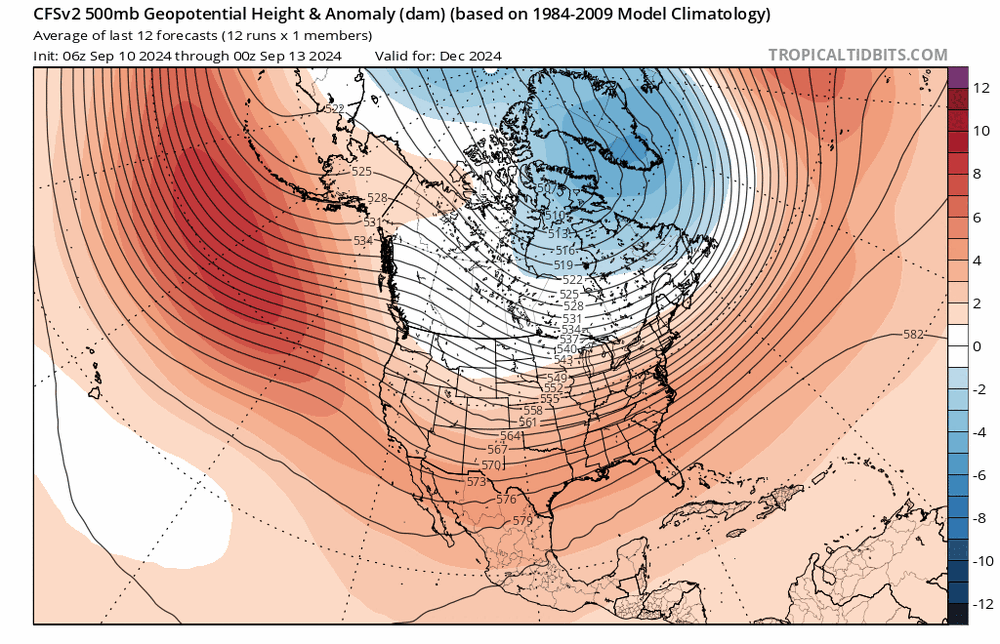 11 minutes ago, raindancewx said:
It's always amusing how no matter what I say on here the most extreme warm/cold case is what people latch onto. When I talk about 2013-14, it's only as a blend with 2021-22 that I'm interested in it. I don't expect the winter to be very much like 2013-14 by itself. The bulge in warmth isn't quite south of Alaska, it's to the West by the dateline which probably favors more cold Plains than Midwest.
Look at the blend.


That's fairly close to what I expect at 500 mb, although I reserve the right to change my mind by the time I put out my forecast.

-
Raindance, your blend looks an awful lot like the CFS.
-
1
-
-
6 minutes ago, raindancewx said:
It's always amusing how no matter what I say on here the most extreme warm/cold case is what people latch onto. When I talk about 2013-14, it's only as a blend with 2021-22 that I'm interested in it. I don't expect the winter to be very much like 2013-14 by itself. The bulge in warmth isn't quite south of Alaska, it's to the West by the dateline which probably favors more cold Plains than Midwest.
Look at the blend.
That's fairly close to what I expect at 500 mb, although I reserve the right to change my mind by the time I put out my forecast.
I don't think anyone feels like you expect a repeat of 2013-2014, but given the the last several years, I think the prospect of a compromise between that year and 2021-2022 is alluring to many on the east coast. Even January 2022 had a very nice stetch.
-
1
-
-
8 hours ago, brooklynwx99 said:
the CFS is probably the best case scenario for winter lovers in the east... the Aleutian ridge has much more of a poleward component and allows a bit of a +PNA to develop. I am very skeptical of any kind of prolonged +PNA with the state of the PDO, though this does echo Raindance's 2013-14 analog fairly well
We have seen some solid PNA stretches....the PNA and PDO do part ways. The more important question is whether or not they are fraudulent, west-baised PNA...like January 2023, or accopanied by a +8SD NAO as they so often have been past 10-15 years.
-
1
-
-
44 minutes ago, snowman19 said:
I mean we’ve been in a default La Niña background pattern for years and nothing has changed in the PAC so……
Aside from the ocassional mismatches that afforded us some wintry reprieves, no....
-
12 hours ago, Damage In Tolland said:
Haven’t hit the 40’s yet thankfully . Leaves are well ahead of normal with a lot of browns from the fungus . Another hideous leaf season enroute
I have had several nights in the 40s already.
-
1
-
-
On 9/10/2024 at 10:00 PM, Terpeast said:
It wouldn’t actually surprise me if December turned out to be our best winter month this year. The hope I hold onto is that it hangs on through part of January allowing us to get in on some action. October will tell us a lot more about where this thing is headed.
@psuhoffman Have a great trip!
I am optimistic for December.
-
1
-
-
18 hours ago, WinterWolf said:
LR is a crapshoot. This one(tropical) Mother nature fooled the pros.
That is part of what makes it fun to me.....how invested I am in winter is a byproduct of my need to get the snowstorm dopamine drip going coulpled with with the challange that LF presents. Its the snow addiciuton that fuels that drive needed to do the forecasting.
-
3
-
-
16 hours ago, snowman19 said:
If there is to be an official trimonthly La Niña 24-25, it needs to make moves NOW. We are at the out of time point here. If this slacks off again for any extended period, I think we end up with a cold-neutral winter
RONI is going to be reflective of a solid la Nina, which is supported by the pattern, as Chuck and Bluewave have been illustrating. I couldn't care less what the ONI does.
-
1
-
-
6 hours ago, SnoSki14 said:
Yes persistence forecasting has made the guy look like a genius but there's very little nuance in his posts. Lots of biased takes pulled from Twitter too.
JB looked like a genius too in the snowy 2000s & 2010s Era. He's just anti JB at this point.
Bluewave and rain do a much better job explaining the rationale behind the warm winters.
Well, yea....but they are the Acuna (when healthy) and Judge of long range forecasting. Snowman has some biases, as we all do, but he clearly knows his shit and adds a lot of value to the dicussion IMO.
-
21 minutes ago, PhiEaglesfan712 said:
2014 is the only other hurricane season in recent history in the Atlantic to be as inactive as this one. That year only had 2 named storms in September: Dolly and Edouard. Coincidentally, this was the last season to have a later dated first storm than this year. 2014 finished with 8 named storms, making it the least active season in the 21st century.
2014 was an active year in the Pacific. That is certainly not the case this September, with Ilena being the only named storm this month.
I think 2014 is @snowman19's top analog.
-
1
-
-
11 hours ago, Torch Tiger said:
I give you a B, as intensity forecasting is a B
Yea, I try to be conservative on this self-grading practice because I know how cheesy that is.
-
1
-
-
2 hours ago, Damage In Tolland said:
Thanks
Nice guess on the intensity...I was surprised by that last minute spike.
-
 1
1
-
1
-
-
1 hour ago, snowman19 said:
Stop ruining this thread with your token, useless garbage. Adults are talking in here. Go slither back to the NYC forum and troll there
JMO...but I think not reacting to posts like that will go a long way towards shedding the 5 PPD. I know its tough....its something I have been working on, as well. Its never desirable to allow someone on the internet to elicit a great deal of negative emotion from you because it causes others to view you in a more negative light.
-
3
-
-
1 hour ago, snowman19 said:
Severely positive, no. But a solidly positive NAO for DJFM? Absolutely
Solidly....yes. .50ish+.
We probably see one month average appreciably negative.
-
Hurricane Francine Strikes Louisiana Stronger Than Anticipated
Track of Francine Very Well Forecast
The Eastern Mass Weather First & Final Call forecast for the landfall of Hurricane Francine was a moderate success with mixed results, as intensity forecast left something to be desired. The system intensified right up until landfall as a category two hurricane with max sustained winds of 100mph, after appearing to have leveled off during most of the day on Wednesday. This was in contrast to the forecast, which called for weakening during the day on Wednesday and landfall as a category one hurricane with max sustained winds of 75mph.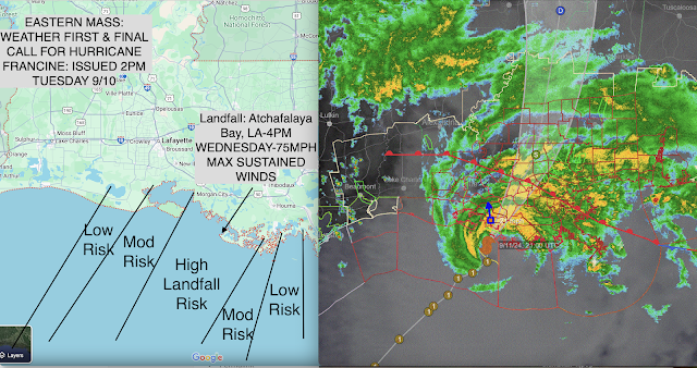

Post Forecast Analysis
In terms of what went "wrong" with the forecast, from a track standpoint, absolutely nothing. The hurricane made landfall at essentially the precise point that it was forecast to, in the marshlands near the east side of Atchafalaya Bay to the southwest of Morgan City, LA. However, the forecast also called for for appreciable weakening during the day on Wednesday due to the continued intrusion of dry air and increasing wind shear in association with the mid level trough approaching from the west. The interaction of tropical entities with mid latitude systems is exceedingly complex and while their influence is often detrimental to the overall welfare of the tropical system, this is not always the case. In this instance, it is likely that divergence aaoft augmented the evacuation of air away from the hurricane at the mid and upper levels of the atmosphere, which acted to negate some of the aforementioned negate influence from drier air and wind shear. In fact, the impact of these inhibitors of development may have also been overstated given that Francine was only a minor to moderate strength hurricane, which needs less than an ideal environment to sustain itself, in contrast to a more intense system.
Final Grade: C+
-
3
-
.png.8baa1381f1ae9b7b5463c934187df92f.png)


2024-2025 La Nina
in Weather Forecasting and Discussion
Posted
Yea, I am not debating that CC may be at play as well given the ITCZ shift, but it would be folly to dismiss the solar relationship. Its very strong and clear as day.