40/70 Benchmark
-
Posts
72,344 -
Joined
-
Last visited
Content Type
Profiles
Blogs
Forums
American Weather
Media Demo
Store
Gallery
Everything posted by 40/70 Benchmark
-
But I thought we knew stein would last all winter when fall was dry?
-
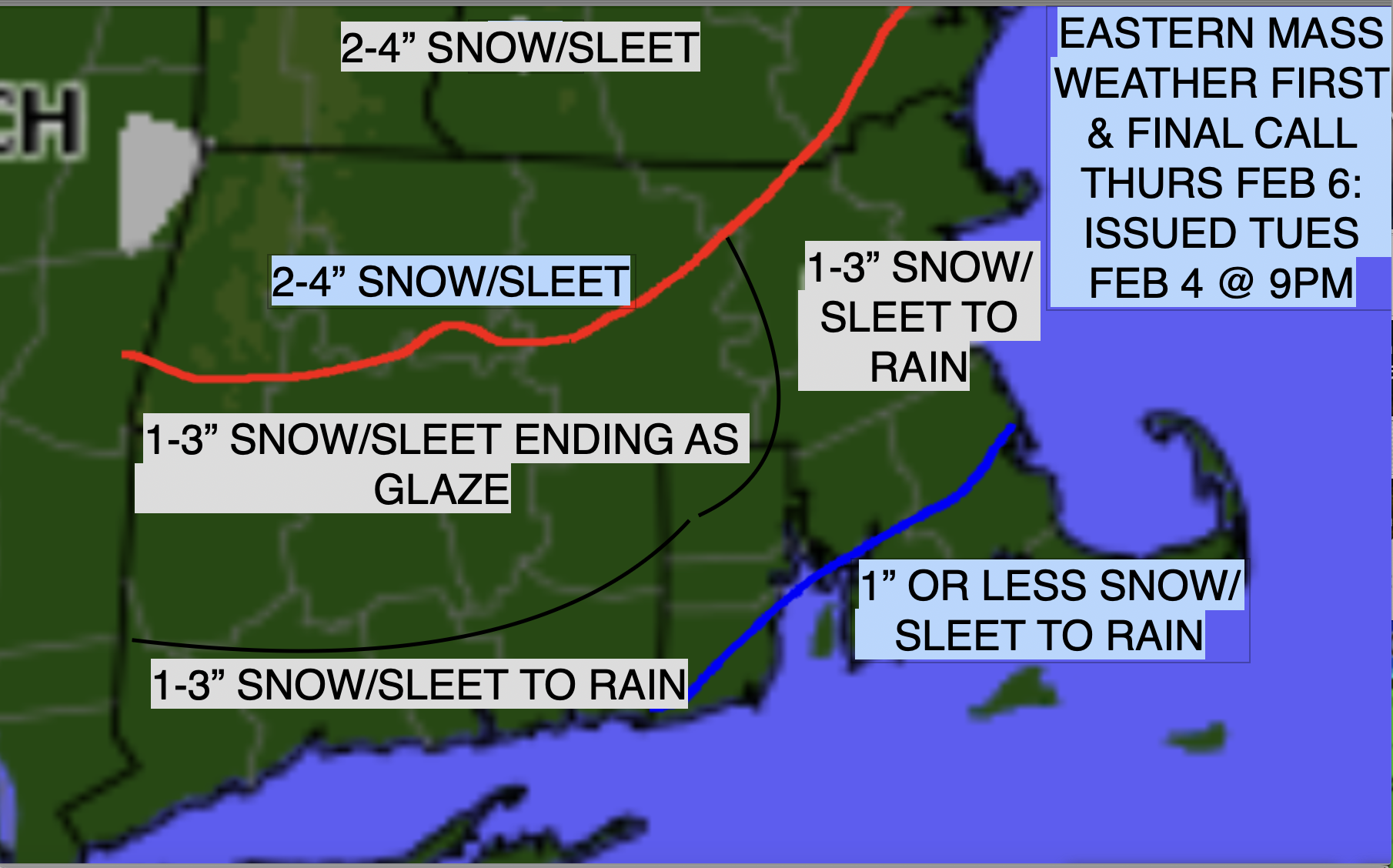
Verification for Messy Thursday Fairly Strong Forecast Here is the reality versus the forecast for the messy Thursday, weak storm system that impacted the region yesterday. The mid level warmth was slightly more aggressive than implied in the forecast, so the 1-3" area would have been better represented by a coating to 2" range, and the 2-4" maximum area to the north should have been 1-3". The slight glaze did indeed materialize towards the end of the event across a large majority of the area, as expected. Final Grade: A-
-

Tracking February 6. Light to moderate event potential
40/70 Benchmark replied to Typhoon Tip's topic in New England
A- https://easternmassweather.blogspot.com/2025/02/verification-for-messy-thursday.html -
Wife is happy to miss it...kids are a bit too young to be really bent out of shape
-
Don't forget the draft material, too..
-
What an orgy of a stretch to have no wife or kids...just unadulterated, meteorological fellatio for over a month
-
Yup.
-
Well..is there a front load that I missed?
-
Every single one of them ends with an erotic moment between the 4 walls, the KU book and me
-
You wonder how much more of this it will take for the masses to accept that things are changing....I mean, hellllooooo......there is a reason the gradient is so fast every waking moment...
-
Yea, this will rot well into March....toss guidance. Family departs for Dubai tomorrow, and I don't join them until mid May, so I'm just going to camp out on the living room floor in my crotchless skipants with a 12 pack of Odouls
-
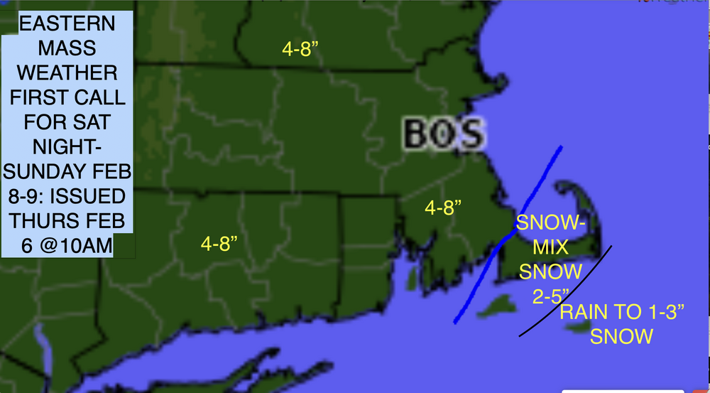
First Call for Weekend Snowfall Several Inches Likely OverNight Saturday Into Sunday Synoptic Overview: The next in a succession of northern stream impulses will approach the area this weekend. The primary difference with this system relative to many of the disturbances that we have dealt with this season is that looks to be intensifying on approach, as opposed to shearing out. This is due at least in part to the Alaskan ridge growing in amplitude, which in turn lowers heights downstream and allows the wave to "dig" a bit on approach. Expected Storm Evolution: Snow looks to break out early in the evening on Saturday from southwest to northeast, and the precipitation shield will have overspread the entire region prior to midnight. Snowfall will mix with sleet and rain along the south coast and especially the cape and islands during the predawn hours on Sunday, with a complete change to to rain likely over the outer cape and Nantucket island. The heaviest amounts should occur in bands that will set up to north of the track of the developing mid level low during this time, along and north of the Mass pike. Precipitation should begin to taper off Sunday AM, and wind down as snowfall everywhere by midday Sunday. FIRST CALL: Final Call will be issued on Saturday.
-
https://www.blogger.com/blog/posts/2820149554058213224
-
Looks good...I like that this one seems to be amplifying on approach in response to that flexing AK ridge....this one could have some banding surprises.
-
Not far off.....family is flying out Friday, so not much room for me to breathe right now...just complete chaos.
-
None of them are particularly enthralling, but some get their rocks off on the conga line of mediocrity.
-
Tracking February 6. Light to moderate event potential
40/70 Benchmark replied to Typhoon Tip's topic in New England
I never bought the 5" amounts with this POS, anyway, so all good. -
Messy Thursday on Tap This Week First & Final Call Synoptic Overview: The first in a long line of northern stream systems will travel the atmospheric conveyor and arrive in region during the day on Thursday. Given that this northern stream jet is so prevalent and the flow so fast, none of these storms will be particularly strong and they will all be fast moving. Expected Storm Evolution: Snowfall looks to break out after the AM commute on Thursday throughout the vast majority of the region, as it will begin my mid morning southwest and later morning northeast. Snowfall will mix and change over to sleet and rain to the south of the Mass pike and near the coast during the afternoon prior to ending, as a warming WSW flow aloft will accompany the storm system into the region. There could be hazardous period of glaze over northern Connecticut, southern portions of the Berkshires and Worcester hills. FIRST & FINAL CALL:
-
Tracking February 6. Light to moderate event potential
40/70 Benchmark replied to Typhoon Tip's topic in New England
https://easternmassweather.blogspot.com/2025/02/messy-thursday-on-tap-this-week.html
-
Not THAT is Circle JERK....
-
Thursday is garbage....maybe a few inches this weekend, but still time on that. Again, no sense of urgency on my part. I don't regret glossing over Sunday night.
-
I know people like to get underneath the flashing neon lights of a large PV disruption and finger the 'ole prostate.....but once you pass the momentary climax that represents the culmination of doing just that, there really isn't much to write home about in this neck of the woods. The hope is that something noteworthy will evolve because there is the chance, but I don't see anything imminent that drives me to the lap top.
-
Unpopular take, but 16" over 16 days really doesn't do a hell of a lot for me TBH. ...my hope is that there is some larger ticket potential towards mid month. But you can shove these 2" installments every 3 days.....just a string of inconvenience.
-
I mentioned Sunday night at the end of my publication last week...didn't warrant much time. This is boring, nuisance crap that I could do without.
-
I have had complete cover since MLK Day.