

40/70 Benchmark
-
Posts
72,327 -
Joined
-
Last visited
Content Type
Profiles
Blogs
Forums
American Weather
Media Demo
Store
Gallery
Everything posted by 40/70 Benchmark
-
I'd be careful about slipping into the defeatist "whoa is me" meterorological stupor type of trap.....things are changing on a multidecadal scale. As far as the "CC will not allow for any more coastal track seasons" philosophy goes.....my only response is to wait and see because nothing anyone says will change your mind.
-

2024-2025 La Nina
40/70 Benchmark replied to George001's topic in Weather Forecasting and Discussion
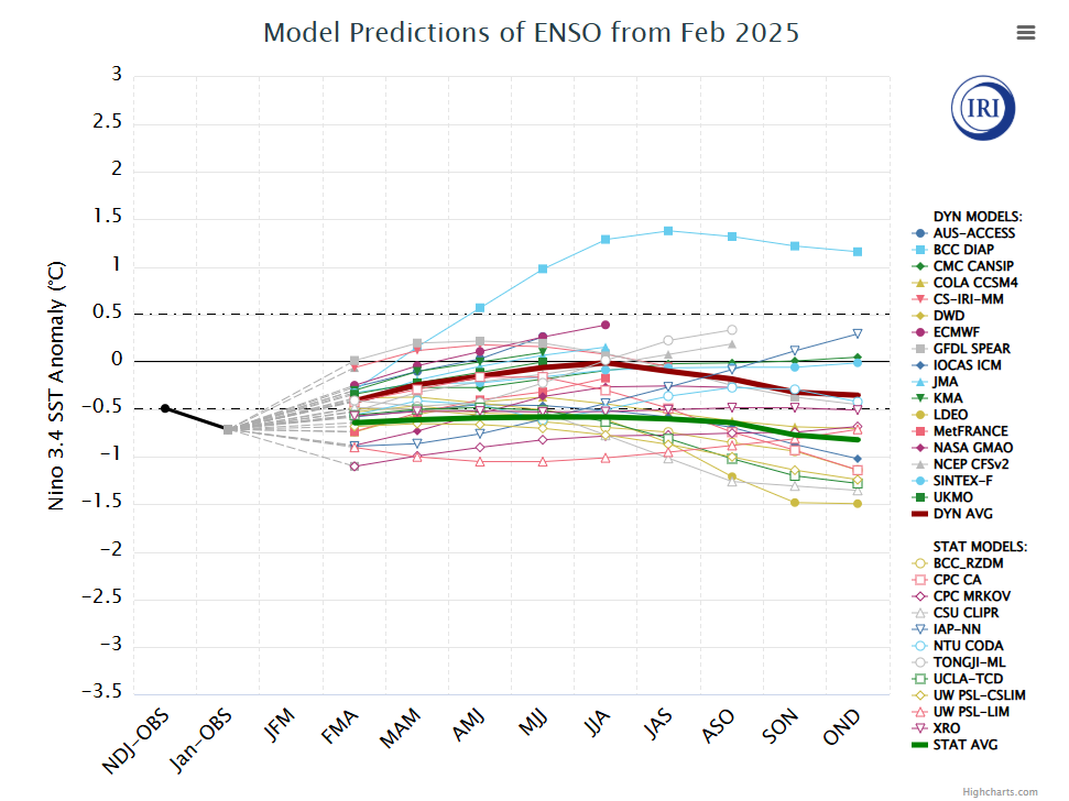
Just a cursory glace at some very preliminary stuff...I'll go on record right now as saying I'll be shocked if there is another La Nina next year. I call BS on the guidance....I could fathom a neutral, but warm ENSO would not suprise me in the least. -
Why do you say that? My early hedge is to expect a lot of them next year.
-
You can probably eliminate that magnitude of positive monthly anomaly just based off of how the first third of the month looks:
-
2024-2025 La Nina
40/70 Benchmark replied to George001's topic in Weather Forecasting and Discussion
-
La Nina is the early betting favorite, but I am far from convinced. I would not be shocked to see a weaker El Nino.
-
2024-2025 La Nina
40/70 Benchmark replied to George001's topic in Weather Forecasting and Discussion
Fine by me...I've been convinced since January its just not the year for SNE because the longwave pattern was just off, despite the cold. It happens. -
Its silly....its like using July 1995 everytime it looks hot or Feb 2015 whenever the pattern looks snowy in SNE...although I think it this point, everyone knows better than to do the latter.
-
I'll go through it all in great detail later this spring, but a bit of regression here in terms of my snowfall forecast....I have had some decent forecasts overall, namely 2022-2023, just not work out in terms of snowfall...but this year largely worked out, despite a pretty flawed forecast. I'm glad I was too warm, as opposed to cold because there was a definite bias in my forecasts. I do not anticipate much more activity.
-
You utilize the March 2012 analog about as much as JB does March 1993.
-
I had two-low end warning events all season, but they both just so happened to come in relatively close proximity to one another during a cold few weeks. That is the reason its a D instead of an F.
-
No....not when the season has 50% of average. It was an awful season with a decent month of February.
-
I mean Feb was enjoyable, but I'd rather have one huge storm in a sea of warmth if I'm getting 50% of average.
-
I couldn't give a rat's scrotum about the cold....believe it or not, I'm not too enamored with the notion of the PV queefing in my face while New Orleans gets a larger storm than I could muster all winter. That is supposed to improve the grade?? While you're at it, perhaps ma nature could throw in a round of testicular cancer for me and I'll nudge the grade up to a B.
-
A few weeks of ice on my driveway doesn't warrant a C...though you didn't get porked as badly as I did......AGAIN. D Getting really old..pretty sure Logan beat me.
-
Jan 7 2024 > any single day of this winter for me. Not close. PS: My seasonal total is still less than last year and I don't anticipate much more.
-
50% of average isn't respectable IMHO. It blew big fat ones.
-
The compression isn't as prevalent an issue in the spring because the PV is lifting out and decaying.
-
Yea, the upper half that doesn't get the sun as been a sheet of ice for about a month.
-
Going to be a a while here, as I still have about a foot in my yard....although the highway medians and such will probably be wiped this week.
-
Back of MJO's skibbies lookn dirt and gritty
-
Looks like maybe something around March 9-10ish....
-
2024-2025 La Nina
40/70 Benchmark replied to George001's topic in Weather Forecasting and Discussion
Awesome. I'm ready. -
Part of it is we always have those limp ridges off of the west coast
-
This has to be the most useless season relative to potential since 2009-2010.


