

40/70 Benchmark
-
Posts
72,761 -
Joined
-
Last visited
Content Type
Profiles
Blogs
Forums
American Weather
Media Demo
Store
Gallery
Posts posted by 40/70 Benchmark
-
-
16 minutes ago, FPizz said:
It is location dependent too, even around here. The past 7 years, in the central nj area 15 miles west of Rutgers University, I am:
a tick below ave
Well below
Way above
66% of av
way below
Ave
66% of ave.
Those 7 years are a hair over 23" average for me and I average 29". So yes, it has been below average. But next year if we happen to get a nice winter, I can be right near average again for the past 8 years. His 7 year thing is so cherry picked it is laughable. The prior 7 year to that I averaged 11" above average. If I combine the 14 years, I am above average overall. Somehow the last 7 years are the new norm, but the 7 years prior to that just get tossed.
Yea, my area has had a lot of bad luck even relative to the general drought.
-
I can fathom the higher terrain of the Worcester hills and Berkshires, up into NNE seeing an increase, but I think I am too far south/close to the coast. Hopefully I can break even with a more feast or famine distribution moving forward.
-
 1
1
-
-
28 minutes ago, LibertyBell said:
If anything your snowfall should go up with added moisture as locations further south see their snowfall go down. We saw this in the DC vs NYC trend back in the early 2000s (it's so strange to say that lol.)
Eh...I think the increase is probably north of me, or at least further inland/elevated. I don't think my snowfall on the interior CP of northern Mass is going to go up verses the longer term climo. Maybe the increased moisture and warmer temps cancel out, as opposed to even further south along the CP....
-
1
-
-
8 minutes ago, bluewave said:
I don’t take it that way. I really enjoy the back and forth here. This format is really great as it allows for the expansion of ideas and extended conversations.
I am open to the concept esstentially anywhere below the latitude of about Manchester, NH...however, from about Manchester points northward, they really haven't been struggling as much during this drought period. Its a viable possibility for CNE and SNE, but we clearly aren't there yet in NNE IMHO.
-
2
-
-
5 minutes ago, bluewave said:
It’s possible that with a bump up over a year or two that the bolded mean may rise off these levels in another 7 years. But my guess is that the reversion will ultimately settle below what we had as a mean when the climate was colder. It’s challenging to get a mean at the level when things were colder since we were able to nickel and dime our way to average between the early 60s to 90s when it was colder. This winter was a nickel and dime special that finished well below average. That was a benefit of a colder climate. More options to get to average or higher.
Entirely possible. Please don't mistake my tone for dismissiveness, as I am open to the idea, but just don't feel its a forgone conclusion yet. Of course that is more likely the further south one travels...
-
3
-
-
9 minutes ago, bluewave said:
We don’t need 7 years in order to know the range of options since the all or nothing snowfall pattern began in the 1990s which is a full 30 years of data. As winters began to warm in places like NYC, the winters mostly became well above or well below average snowfall. The middle range snowfall scenario season became few and far between. So as the winters have continued warming this decade, the below average outcome has become more likely.
Hopefully, we can see a snowfall bounce in one or more seasons over the next 7 years. So I agree with one aspect of your comment as to which range of outlined options we experience. But the reversion to the mean you speak of will be a lower mean than was experienced in a colder climate. For the past 7 seasons, Boston has reverted to what used to be the snowfall mean closer to NYC. NYC has reverted to what was average around Philly in a colder era. And Philly snowfall has become more likely the old climate in DC. So in effect the northward shift in storm tracks also shifted the snowfall climate zones more to the north.
I agree regarding the growing feast or famine distributuon of the snowfall, but at least at this latitude, talk to me in 7 years regarding the bolded.
-
7 hours ago, Stormchaserchuck1 said:
It was kind of a La Nina pattern this past Winter, and last year starting in about May. That's why it was so dry.. do you remember how it rained like not at all last Summer in the Northeast, and was hot? That's usually a La Nina pattern. The Winter somewhat fit it too, being cold and dry. I've correlated the ENSO subsurface with better pattern conditions than surface SSTs.. and the subsurface has been in La Nina range pretty much since February 2024. Even now, it's still weakly La Nina in the central subsurface.
Goes along with my wholistic approach of measuring ENSO intensity being indicative of weak La Nina.
-
9 hours ago, Stormchaserchuck1 said:
That's a long time. If 80% of the months of the whole year are above average, it's no mystery that snowfall goes down with 3/4 Winter months above average.. at least near the Mid Atlantic where the 32F mark is so sensitive.
I still contest that we are in a "Hadley Cell expansion cycle" decadally in both the Pacific and the Atlantic, and that real snowfall decline is probably closer to ~15%. Precipitable water has been just as high globally as average temperature.
I live on the NH border.
Obviously its possible mean snowfall is in decline even at this latitude, but I need to see more data than a 7 year snow drought on the heels of the snowiest decade on record capped off with over 100" in 30 days.
-
2
-
-
4 hours ago, bluewave said:
The significance of past snow droughts ,which were weaker than what we have been experiencing over the past 7 years, is that they were due to cyclical drier patterns in a significantly colder climate. So once the dry patterns abated, the snows returned with record seasons in the early 1930s, early 1960s, late 1970s, and early to mid 1990s.
This has been the first snow drought from Philly to Boston that has largely been the result of both warm winters and warm storm tracks. Which is the function of a steadily warming climate. It will be a significant challenge for this climate to produce another winter snowfall outcome like 1933-1934, 1957-1958, 1960-1961, 1977-1978, 1993-1994, and 1995-1996. Those were the winters which followed past very low 7 year snowfall stretches. It’s has become too warm to get cold and snowy winters of that magnitude.
So this leaves a few options going forward. Option one is a continuation of this very low snowfall regime right into the 2030s. The next scenario is a bounce back to snowier than the last 7 years, but well below what was experienced in the 2010s. Such a bounce would probably be transient before the lower snowfall totals resume in the 2030s. The lowest probability outcome next 7 years is a return to the 2009-2010 to 2017-2018 snowfall bonanza since many of background climate signals from that era have shifted warmer including storm tracks and overall warmth.
Talk to me in 7 years.
-
 1
1
-
-
43 minutes ago, michsnowfreak said:
Thats insane.
Whats funny is id heard several of the normies refer to this as an "old fashioned" winter. lmao, yet snowfall was way below avg, but give them a cold, white Jan & Feb with ice covered lakes and it does the trick I guess. Meanwhile, 2 years ago we saw 8" more snow than this season but we heard what a mild winter it was, and I also heard multiple times in some heavier snow winters that finished well above avg that this was a "normal" MI winter.
Ive learned over the years that the general public base their general opinion of a winter (here at least) off of how cold and snowcovered Jan/Feb are. Doesnt matter how much (or how little) snow falls in Oct-Dec or Mar-May. And Ive learned that the general consensus of snow weenies is all about that final snowfall number, regardless how the winter was overall. (Again, these generalizations dont apply to all).
The vast majority have little knowledge of climo so their opinion is based entirely on anecodtal and subjective observations.
-
 1
1
-
-
1 hour ago, michsnowfreak said:
That 7 year "snow drought" talk is very over the top IMO. Its a simple regression to get closer to the mean. Its been happening since the beginning of climate records, and its how averages come to be.
I looked at a few places. For starters, it looks like only NYC is the one who can claim their all-time low for the past 7 years, not the entire region. And for what thats worth, there were other 7 year periods closer to this 7-year low (1920s & 1950s) than any were to the 7-year high from 2010-16.
But the bigger picture is that I just dont understand how the anomalously high number of heavy snow winters in the 2000s and 2010s are just dismissed as if they never happened when discussing recent low snow years. I mean, we arent talking generations ago, and we arent talking slightly above avg snowfall. We are talking very recent years that we ALL remember and that set one heavy snow record after another.
NYC avg snowfall last 7 years: 14.9”
7 yr avg 2009-10 thru 2015-16: 41.0”
POR avg 28.2”
21st century avg: 29.0”Boston avg snowfall last 7 years: 26.6”
7 yr avg 2008-09 thru 2014-15: 60.7”
POR avg: 42.4”
21st century avg: 44.8”Portland, ME avg snowfall last 7 yrs: 51.4”
7 yr avg 2011-12 thru 2017-18: 79.8”
POR avg: 65.7”
21st century avg: 66.6”**********
Detroit avg last 7 years: 36.6”
7 yr avg 2007-08 thru 2013-14: 59.8”
POR avg: 40.9”
21st century avg: 45.8”
Chicago avg last 7 years: 32.2”
7 yr avg 2007-08 thru 2013-14: 51.0”
POR avg: 36.4”
21st century avg: 38.0”Milwaukee avg last 7 years: 40.8”
7 yr avg 2007-08 thru 2013-14: 59.0”
POR avg 47.3”
21st century avg: 47.2”
My mean snowfall since 2015 has just now dropped below the longer term mean snowfall after this past season...just to put things into perspective regarding how bannanas 2014-2015 was.
-
 1
1
-
-
6 minutes ago, snowman19 said:
I’m not assuming anything given its way, way too early to even begin thinking about next winter. That said, a -PDO would not surprise me, although I do not think it will be anywhere near as strong as we have seen over the last 5+ years, which were record breakingYes, agreed.
-
1
-
-
On 4/20/2025 at 11:05 AM, snowman19 said:
I’m going to take into account the global warming skew and say this past winter was a “late bloomer” weak La Niña. There was very dramatic cooling and EWBs starting in late November/DecemberAbsolutely, which I was expecting usuing the 2008 analog.
-
On 4/19/2025 at 3:50 PM, Stormchaserchuck1 said:
CPC actually says that last Winter was Neutral

If you take into account the global warming skew, it was a very Weak Nina.
"Neutral" after Neutral doesn't actually mean much - it just means that ENSO is a weak signal. If this year is Neutral though, it would only be the 2nd time for back-to-back Neutral's since 93-94 (12-13 to 13-14 was the only other one).
The back-to-back stuff has valiance because El Nino's and La Nina's warm or cool the atmosphere in lagged time, but that's less relevant this year.
I consider it a weak La Nina given I consider more than the technical 5 consecutive tri monthly period criteria.
-
On 4/19/2025 at 9:17 AM, snowman19 said:
If the projected summer global picture (cold-neutral “Nada” ENSO coming off a La Niña, -QBO, -PMM, -PDO, still elevated solar/geomag activity) continues into the fall, I have a feeling that the winter forecast is not going to be a cut and dry easy one at all, not that any of them ever really are, but this one may be exceptionally difficult
I'm not so sure one can assume a -PDO next winter...
-
I don't know why anyone should read too much into the 7 year snow drought after that stretch that we just had the previous decade.....still looks like simple regression to me, regardless of the catalyst.
If you want to surmise anything behond that, talk to me in another 7 years.
-
4
-
-
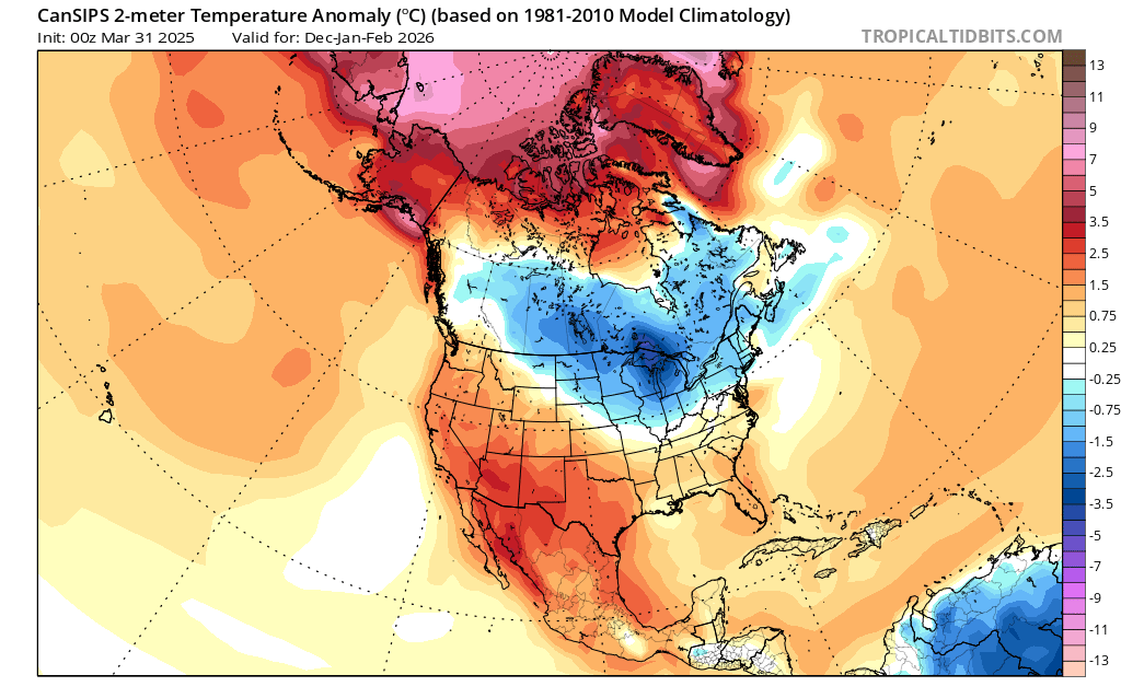
9 hours ago, bristolri_wx said:
The CFS thinks the earth is on fire all the time. CANSIPS DJF 25/26:

CANSIPS did a good job last year.
-
1 hour ago, Stormchaserchuck1 said:
I'll have to do a write up in the next few days, now that US climate division data has updated.. I actually did good on methodology, but it didn't translate at the surface to -PNA (SE ridge), so that was my flaw. Natural Gas though jumped 60% this Winter, so if you went with the CPC's cooler forecast, you could have made money.
I will do it in a couple of weeks.
-
3 hours ago, CoastalWx said:
Man Saturday looks epic. Mid 70s.
What a difference a week makes...I awakened to snow on the ground last Saturday.
-
20 hours ago, beavis1729 said:
I know analogs aren't going to be relevant at every single location in the lower 48...but 2013-14 was one of the harshest winters on record in parts of the Midwest with respect to both cold and snow, and 2024-25 was one of the least harsh and most boring & uneventful winters that I can remember in my lifetime (I've lived in northern IL for 45 years)...at least when using snow depth days (SDDs) as a metric.
In terms of sensible outcomes and "feel", the two winters were literally as opposite from each other as possible. It wasn't even close. One example of this is that Chicago and Detroit had near record snowfall in 2013-14, while Moline IL (not very far away from Chicago) just had their least snowy winter on record in 2024-25. While there were definitely some cold outbreaks this past winter, the severity was unfortunately mitigated in may areas due to lack of snow cover over a large swath of real estate. With decent snow cover, this past winter could have been a memorably cold winter here...but instead it was just "meh".
None of this is meant to be a knock on your post/conclusions. I'm just suggesting that, for a winter weather lover, it all comes down to sensible weather/feel and IMBY outcomes.
Same here....2013-2014 had above normal snowfall, whiile this past winter was brutal. However, obviosuly snowfall is subject to a high degree of variance and I do see the value in 2013-2014 as one of the better analogs.
-
On 4/12/2025 at 10:13 AM, Stormchaserchuck1 said:
Cold water in the subsurface is trying to get squeezed out.. but this negative pool in the central-subsurface should at the very least keep us away from El Nino in the next few months.

Yea, means a moderate-strong El Nino is probably off of the table, which we had all assumed.
-
18 hours ago, Prismshine Productions said:
You had a decent rebound after an ugly start... How much you had last winter?
Sent from my SM-S156V using Tapatalk
No, I didn't.
The season was brutal.
34.25".
-
1
-
-
On 2/27/2025 at 6:09 PM, 40/70 Benchmark said:
+.5"
32"
+.5"
32.5"
-
32.9
1/2"
Mod Snow
-
1
-
2025-2026 ENSO
in Weather Forecasting and Discussion
Posted
Not sure @bluewavewould agree...