

40/70 Benchmark
-
Posts
68,963 -
Joined
-
Last visited
Content Type
Profiles
Blogs
Forums
American Weather
Media Demo
Store
Gallery
Posts posted by 40/70 Benchmark
-
-
3 minutes ago, bluewave said:
First time since 1968 with no Atlantic named storm formations between August 13th and September 3rd which was a developing moderate El Niño summer into winter.
Hey, the consensus clearly missed something this summer and fall, so hopefully it misses siomething with respect to the winter.
-
 4
4
-
-
11 hours ago, Stormchaserchuck1 said:
I'm all over it. +QBO/La Nina gives us about a 75% probability of having a cold 10mb for the Winter, which is actually a high percentage. I just think that strong PV downwells to amplify RNA conditions, as it has done that for the last 15 years. Of course there is some chance of a Stratosphere warming, but I am less keen on a -NAO of late, because it is not dominating the pattern like the Pacific is.
Haven't you posted on several occasions something to the effect that +NAO has been coinciding with +PNA and -NAO with RNA??
-
1 minute ago, Damage In Tolland said:
Noting but sun , dry , Stein weather as far as can be seen . Absolute boredom
No big sou' easter this weekend?
-
-
5 hours ago, weatherwiz said:
Aren't the official tropical outlooks created by inputting a slew of various parameters with applications of physics, incorporating climatology, and running simulations upon simulations to derive the forecasts?
The hyper active forecasts seemed to rely on two major factors;
1) Decaying EL Nino and developing La Nina.
2) The record warm waters/OHC going through spring.
We'll see what happens through the next 8 weeks, but let's say even if we tack on another 7-8 storms, maybe 75% of those achieve hurricane status, 1-2 of those become major, and we don't see any significant landfalling impacts and the season ends at this.
Instead of folks admitting the forecast was off, Beryl will be used to justify because of ridiculously high ACE. That's ridiculous. There is no questioning Beryl was in the historic category, however, you can't use that one storm to define the entire season. I mean you can but the truth of the matter is that one storm was not reflective of the entire story. If you got 52 inches of snow during the winter (and your average is like 49'') but 25'' of that came within one storm, are you going to quantify the winter as "epic" because of that one storm. That one storm was not reflective of the season, it was reflective of short-term processes.
You basically described 1996-1997 winter and no, we don't consider that season epic.
-
 1
1
-
-
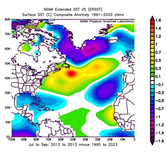
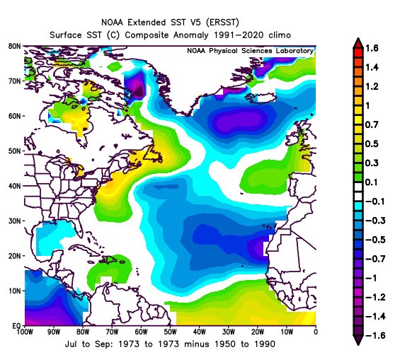
1973 is a decent analog....2013, not so much.
-
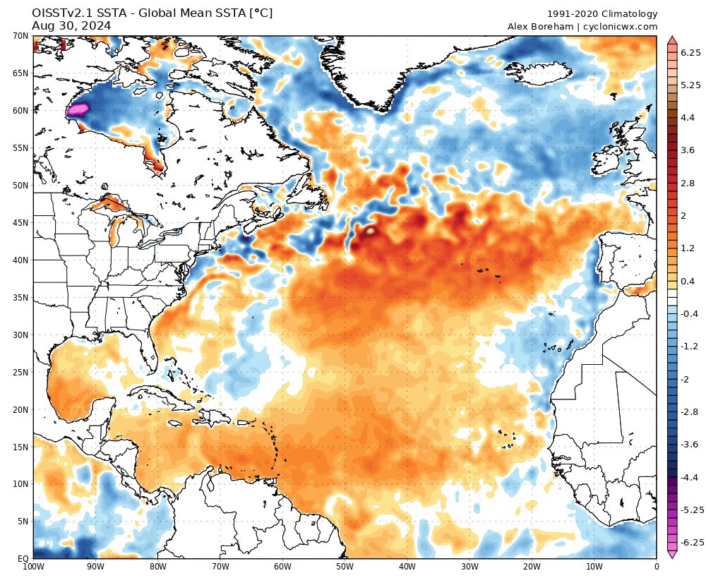
12 minutes ago, PhiEaglesfan712 said:
Another reason for the low number of named storms this year is the SSTa configuration. It mirrors quiet non-el Nino years like 1970, 1973, and 2013:
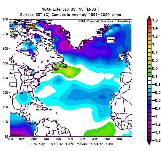
Interesting and probably coincidentally, 1970 is the only high solar La Nina that was great for snowfall in the NE.
-
5 hours ago, snowman19 said:
If you look further, the high ACE years were not only low sunspots but also majority low geomag
Well, that goes without saying.
-
1
-
-
2 hours ago, Stormchaserchuck1 said:
Per the CPC's NAO measurement, since Winter 11-12, 44/52 (84%) Winter months (DJFM) have been +NAO! That's 44-8. In that time, 19/20 >1.11 NAO months have been positive (95%)! Since 13-14, 16/16 Winter months with NAO >1.11 have all been positive.
Dec has been +NAO 11 of the last 13 years (85%)
January has been +NAO 12 of the last 13 years (92%)
February has been +NAO 12 of the last 13 years (92%)
March has been +NAO 9 of the last 13 years (72%)
The CPC does weigh heavily on the south part of that index, as I've found out (we've had some Greenland blocks but there remained high pressure near the Azores, they call that +nao).
And we've had strong -PDO since 2016. So, the Atlantic and Pacific have both been unfavorable together by actually a pretty good standard deviation.
Add to it the fact that climate change has been associated with more precipitation/global precipitable water, and I would say that our problems in the Winter with snow have probably been something like 10-15% global warming. A lot of the warm forecasts in this regard are more based on consistency than the average global temperature.
Yea, CC certainly isn't helping, but its mainly just been that the pattern has been awful.
-
2
-
-
1 hour ago, kdxken said:
I thought you liked Ray? Just kidding Ray!!!!
Heh...I've hooked him up the past couple of seasons.
-
 2
2
-
-
6 minutes ago, GaWx said:
Do you think that the current very active sun could be one of the main factors (especially when considering lag) keeping the recent Atlantic tropics quiet? Aug of 2024 had a 216, the highest mean sunspots in Aug since 1991. That means that this Aug had the highest mean for Aug of the current active Atlantic tropics era so far.
https://www.sidc.be/SILSO/DATA/SN_m_tot_V2.0.txt
Per met. Joe D’Aleo:
“We have mentioned the strong solar spike which research has shown can suppress hurricane activity.”
“One negative may be the big spike in solar in cycle 25. Most cycles have had a dual max and recent ones had the second one higher. This warms the upper atmosphere and hampers development.”If you look at most of the hyper ACE seasons, they were near solar min...just like neg NAO .
-
1
-
1
-
-
Crazy how the season just tanked after the historic Beryl.
-
6
-
-
6 hours ago, mitchnick said:
Comparing this run to August's, it's a little cooler here in south central PA in Dec & Jan and a little warmer in Feb. In typical Nina fashion, unfortunately, it's a dry'ish run for much of the east. Verbatim, January looks like our best shot for wintry weather, which is typical here in Niñas. Really looks like a congrats NNE and Midwest sorta year.
I'll take my chances on precip with a +NAO and inferno over the ATL....hedge warmer and wetter given CC.
-
1
-
-
4.04" to close out August
2 days of 90+
-
3
-
-
Only 4 amarillos have queefed in Albuquerque this August. Usually the good snow years in Boston have at least 6 queefs on the northeast side of the plateau here between August 15-19 alone. My data has between 3 and 5 queefs as a pretty solid southwest cold signal for January and February with above average precip for wherever I live.
-
4 hours ago, SnoSki14 said:
His schtick regarding winter forecasts is not that much different than JB though, just the opposite (always warm, snowless winter).
And yeah more often than not he'll be right due to pattern persistence and background warming from CC. But there's no nuance, just copy and paste.
People have said the same thing about Raindance and I was quick to point out that he has yet to be wrong. 5PPD for a correct bias??
-
4
-
-
45 minutes ago, Stormchaserchuck1 said:
Also, the only two times since 2010 the N. Atlantic SST Winter NAO predictor was this positive was 2018 and 2013. We had 15 NS and 14NS, and 2 MH, 0 MH in those years. I said before, if there is a correlation between ACE and -NAO in the Winter, maybe there is a chicken/egg equation there.. I think it's probably because global factors hold a state that is correlation, not because of the actual storms, but because the same things leading to X have the same result..
I don't think it's the NAO it correlates to...more the subtropical ridge.
-
2 hours ago, mitchnick said:
It's like instantly adding 1 or 2 posts per day to his limit, assuming he's still limited.
For the record, I don't see why he couldn't be allowed to post in here without limit. I don't know what's gone on in the other forums, but everyone in here seems to get along reasonably well considering the different viewpoints.
But then again, I got suspended last winter for 6 days because of a political post, so maybe I'm not the one to ask! LOL
I have asked the mods, but I get ignored....snowman should not be 5 PPD.
-
6
-
1
-
-
8 hours ago, FPizz said:
This is from the American Met Society below. So to me it is just another hypothesis that might be correct because the information is sound, but it might also be 100% false. With doing pharma submissions for the whole world, we see peer reviewed stuff all the time that eventually turns out to be 100% wrong. Way to many times peer reviewed stuff is quoted and posted as gospel.
Just because a paper was published after undergoing “peer review” does not make it absolutely correct or perfect, nor is it the final message on that idea.
That isn't the point.
-
2 minutes ago, FPizz said:
Just because something is peer reviewed doesn't make it gospel. You can find 1000s of peer reviewed literature that is wrong. I see it all the time in the pharma world.
No study is guaranteed to be 100% true.....that is why they are publications predicated upon a hypothesis from the data. However, having it peer reviewed defintely validates it in my mind.
-
3
-
-
I swear, you could express optimism that you are going to get laid on a Friday night after a long week, and Bluewave would instantly sling a peer reviewed CC article from his holster to suggest otherwise.
-
3
-
-
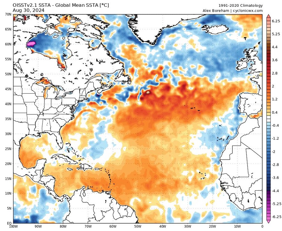
17 minutes ago, bluewave said:
The Atlantic is still near the warmest on record. The last time there were forecasts for an AMO shift back in 2013 to 2017 the weak cooling only lasted for a few years. Then the SSTs reached record levels over recent years. So this could be an indication that aerosol reductions are playing a role and that the reduction is inhibiting a return to a cooler phase. But we may need a few decades more of observations to confirm.
https://link.springer.com/article/10.1007/s00704-022-04207-0
Is Atlantic Multidecadal Oscillation a genuine representation of natural variability in the climate system? Or perhaps is it strongly forced by external drivers? In this paper, a data-driven attribution investigation has been performed for the Atlantic Multidecadal Oscillation (AMO) behaviour in the past via a machine learning technique, NN modelling. We clearly see a forced nature of AMO in the last 150 years, with a strong contribution of the forcing coming from anthropogenic sulphates, which induces its typical oscillating behaviour. The following original application of our model to future predictions of the AMO behaviour shows that it shall probably lose its oscillating characteristic features. The only way to recover them is to consider an unrealistic increase in anthropogenic sulphates in the future under a strong mitigation scenario, and possibly a low-power solar regime. Due to the established influence of AMO on climate and meteorological phenomena in several regions of the world, our results can be important to better understand the past and envisage several future scenarios.
I don't think its going to halt the cycle...rather what is more likely is the negative mode won't be as intense or perhaps long lasting.
-
29 minutes ago, PhiEaglesfan712 said:
If we are really flipping to a -AMO, then I guess a flip from the secular -PDO to a secular +PDO period is going to soon follow. When we flipped to +AMO in ~1995, the secular +PDO period (which began in 1976) soon flipped to a secular -PDO following the next el nino -> la nina transition in 1998. That winter we get the -AMO, +PDO, and el nino combination (especially if it's moderate) is going to be a fun and wild one.
PDO should start of flip later this decade, along with the AMO.
-
36 minutes ago, snowman19 said:
I think we may be in the very early stages of the Atlantic starting to flip to a -AMO. *Maybe*. If that’s indeed what’s happening, it’s going to be a slow evolution over many months. We won’t know for sure until next summer
Right...that is what I was saying to you the other day, after raindance mentioned it. Probably not a huge factor for this winter, but just something to be aware of.
2024-2025 La Nina
in Weather Forecasting and Discussion
Posted
Yes, we have heard about 746 times about this mismatch needed to ever snow again below the latitude of Caribou, ME. I wasn't challenging anything. Simply speaking anecdotally.
I will go out on a limb and say its not going to be warmer or have less snow than last season....those images could be worse for NE. That looks like some pretty decent poleward Aleutian ridging.