nchighcountrywx
-
Posts
2,647 -
Joined
-
Last visited
About nchighcountrywx

Recent Profile Visitors
.thumb.jpg.9707d4addca3d84715ae3d888c5c10d6.jpg)


-
2025 Spring/Summer Mountain Thread
nchighcountrywx replied to Maggie Valley Steve's topic in Southeastern States

-
2024-2025 Fall/Winter Mountain Thread
nchighcountrywx replied to Buckethead's topic in Southeastern States
32 years ago today -
32 years ago today
-
2024-2025 Fall/Winter Mountain Thread
nchighcountrywx replied to Buckethead's topic in Southeastern States
-
2024-2025 Fall/Winter Mountain Thread
nchighcountrywx replied to Buckethead's topic in Southeastern States
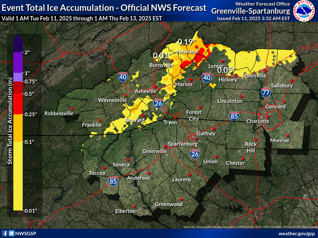
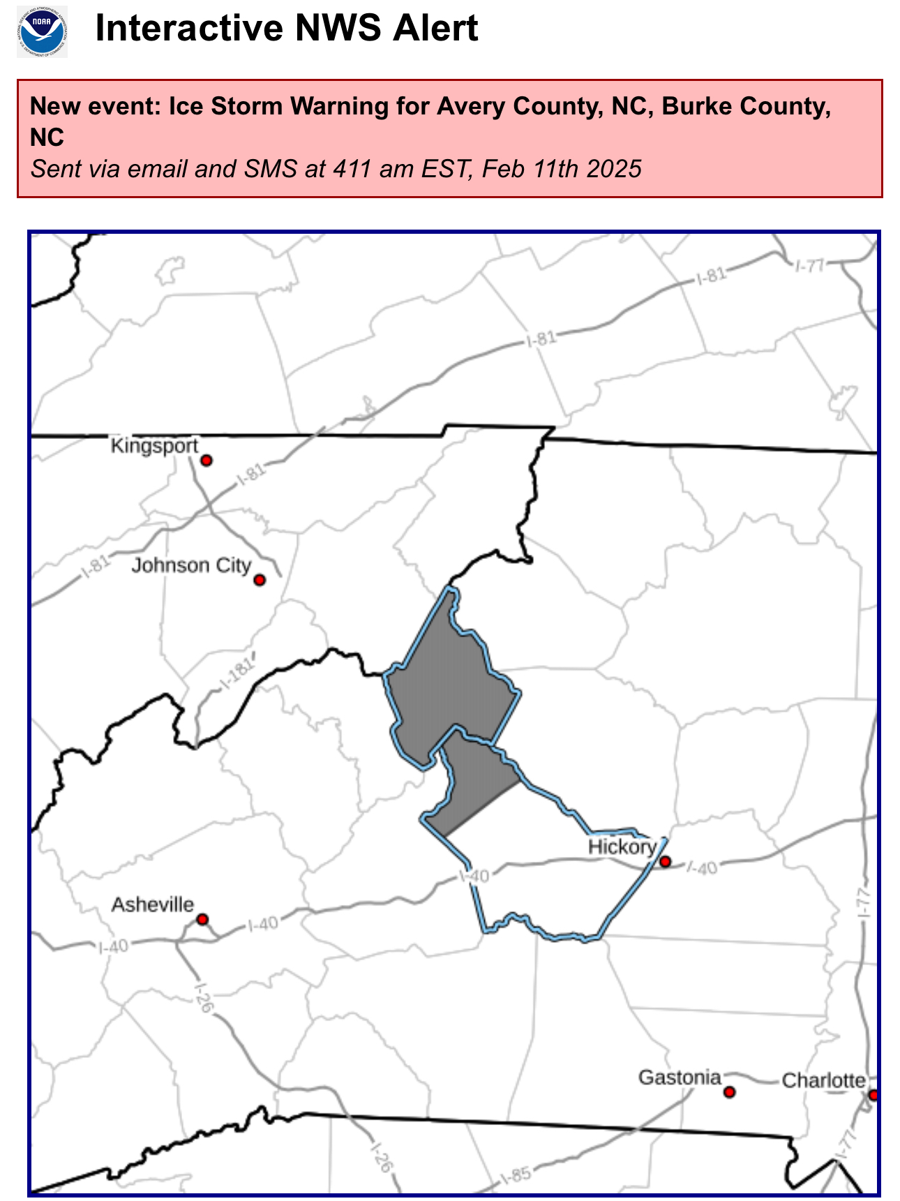
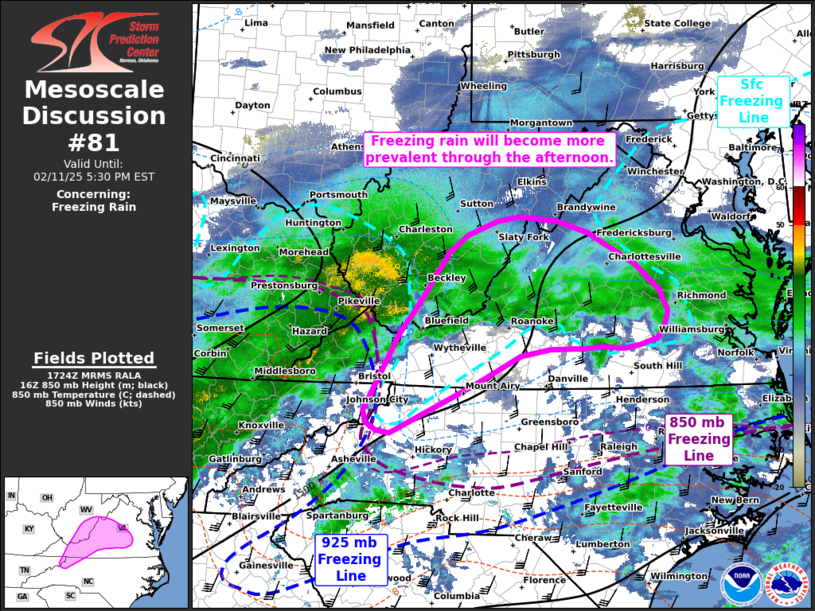
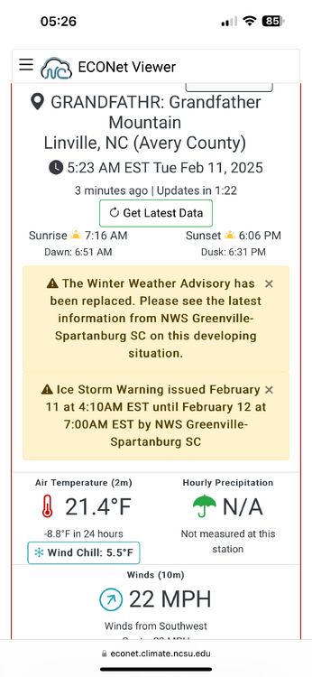
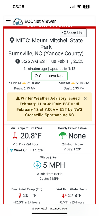
PRECIP RATES THROUGH THE DAY ARE EXPECTED TO BE TAME, WITH FORCING LIMITED TO RATHER SHALLOW ISENTROPIC LIFT. AS SUCH, ANY FREEZING RAIN SHOULD BE WELL WITHIN THE BOUNDARIES OF WINTER WX ADVISORY CRITERIA THROUGH THE DAYLIGHT HOURS. HOWEVER, PRECIP RATES WILL PICK UP THIS EVENING INTO THE OVERNIGHT, AS THE BAND OF FRONTOGENETICAL FORCING SHIFTS EAST. THIS IS WHEN THINGS COULD GET INTERESTING IN TERMS OF ICE ACCRETION ACROSS THE BLUE RIDGE AREAS OF THE NORTHERN MOUNTAINS. TEMPERATURES ARE EXPECTED TO GRADUALLY WARM THIS AFTERNOON/ EVENING, AS THE PARENT HIGH WEAKENS AND MOVES OFF THE COAST. HOWEVER, THE SURFACE PATTERN ACROSS THE NORTHERN CONUS AND SOUTHERN CANADA IS ACTUALLY RATHER COMPLEX, WITH TWO ANTICYCLONES EMBEDDED WITHIN A BROADER RIDGE. ONE OF THESE WILL BE STRENGTHENING (TO > 1030 MB) AND LOCATED SOUTH OF HUDSONS BAY BY 00Z WED...I.E., MOVING INTO AN INCREASINGLY FAVORABLE POSITION FOR REINFORCING THE CAD. THEREFORE, IT'S NOT AT ALL CLEAR THAT LOCATIONS ALONG THE NORTHERN BLUE RIDGE...ESP EAST OF THE CONTINENTAL DIVIDE WILL WARM ABOVE FREEZING BEFORE THE HEAVIER PRECIP RATES ARRIVE. AS A CONSEQUENCE, IT'S ENTIRELY POSSIBLE THAT A NARROW AXIS OF DAMAGING ICE (.25-.5") WILL DEVELOP ACROSS EASTERN AVERY COUNTY AS WELL AS FAR SOUTHERN MITCHELL/YANCEY, AND AREAS ABOVE ~2500' IN MCDOWELL/BURKE/CALDWELL. AFTER COLLABORATION WITH NWS BLACKSBURG, THERE IS ENOUGH CONFIDENCE IN THIS SCENARIO TO UPGRADE TO AN ICE STORM WARNING IN AVERY AND BURKE MOUNTAINS. FOR THE REST OF THIS AREA, CONFIDENCE IS NOT AS HIGH THAT ENOUGH OF THE FORECAST ZONE WILL SEE WARNING CRITERIA TO WARRANT AN UPGRADE, BUT WORDING TO THIS EFFECT WILL BE MENTIONED IN THE UPDATED ADVISORY. OTHERWISE, NO CHANGES ARE PLANNED TO CURRENT HEADLINES. OUTSIDE OF THE NORTHERN MOUNTAINS, THE REMAINDER OF THE ADVISED AREA SHOULD SEE UNDER 0.1" OF ICE, WITH ONLY MINOR TRAVEL DIFFICULTIES EXPECTED OWING TO MARGINAL TEMPS AND WARM ROADS. -
2024-2025 Fall/Winter Mountain Thread
nchighcountrywx replied to Buckethead's topic in Southeastern States
Guidance from GSP…
-
2024-2025 Fall/Winter Mountain Thread
nchighcountrywx replied to Buckethead's topic in Southeastern States
-
2024-2025 Fall/Winter Mountain Thread
nchighcountrywx replied to Buckethead's topic in Southeastern States
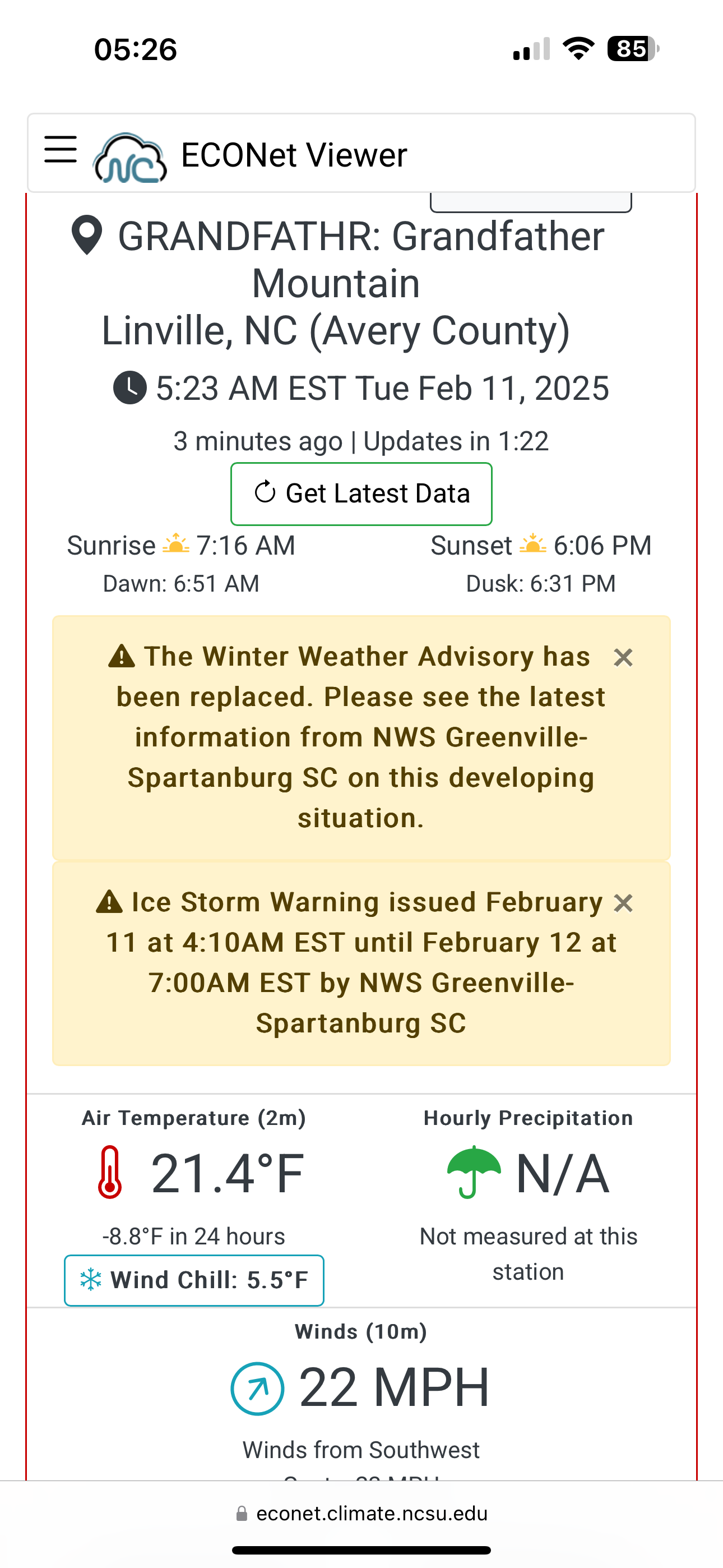
Ice Storm Warning https://inws.ncep.noaa.gov/a/a.php?i=109304611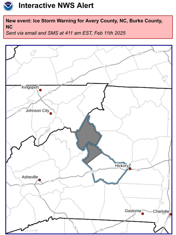
-
2024-2025 Fall/Winter Mountain Thread
nchighcountrywx replied to Buckethead's topic in Southeastern States
All in one place images: https://www.weather.gov/gsp/winter#tab-6 -
2024-2025 Fall/Winter Mountain Thread
nchighcountrywx replied to Buckethead's topic in Southeastern States
Courtesy of Raysweather A potent low forms in Oklahoma Sunday. It will be in Kentucky Monday before transferring energy to a coastal low late Monday. Temperatures look tricky, but we look "just out of the money." Overrunning moisture may arrive in time to produce a period of mixed precipitation (light rain and snow) on Sunday afternoon. The heaviest precipitation comes Sunday night. Dynamic coolling at the beginning of the heaviest rain may cool the atmosphere to give us a mix of rain and snow, but temperatures will warm aloft producing just rain later Sunday night into early Monday. A front moves through Monday, and much colder air arrives. Precipitation changes to snow showers and flurries, ending Monday evening. Like so many before, this NW flow event will favor west over east for light accumulations of snow. Tuesday will be cold with more sun. But the coldest air of the season may accompany a secondary front arriving late Wednesday. Again a few snow showers or flurries may follow the front Wednesday night. Cold weather will be with us for the first two weeks of January, but currently, there's no real candidate for a significant snow. -
2024-2025 Fall/Winter Mountain Thread
nchighcountrywx replied to Buckethead's topic in Southeastern States
Thoughts? I have concerns about the null phase in January
-
2024-2025 Fall/Winter Mountain Thread
nchighcountrywx replied to Buckethead's topic in Southeastern States
A Thanksgiving Day Prayer O God of Whose mercies there is no number, and of Whose goodness the treasure is infinite: we render thanks to Thy most gracious Majesty for the gifts Thou hast bestowed upon us, always beseeching Thy clemency; that as Thou grantest the petitions of them that ask Thee, Thou wilt prepare them for the greater rewards that still await them. Taken from the Collect of the Votive Mass of Thanksgiving
-
2024-2025 Fall/Winter Mountain Thread
nchighcountrywx replied to Buckethead's topic in Southeastern States
I noticed Raysweather has posted his winter snowfall predicitons. About half of normal.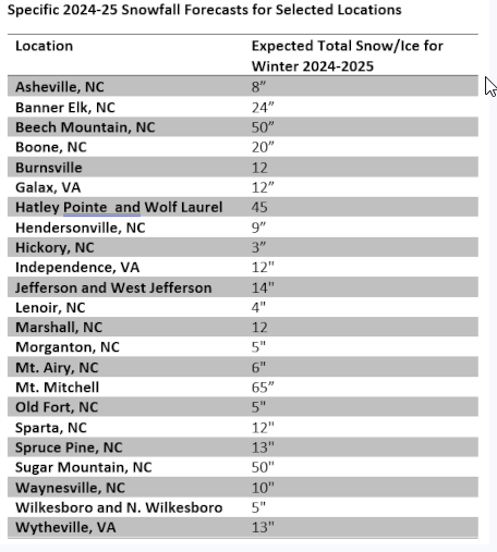
-
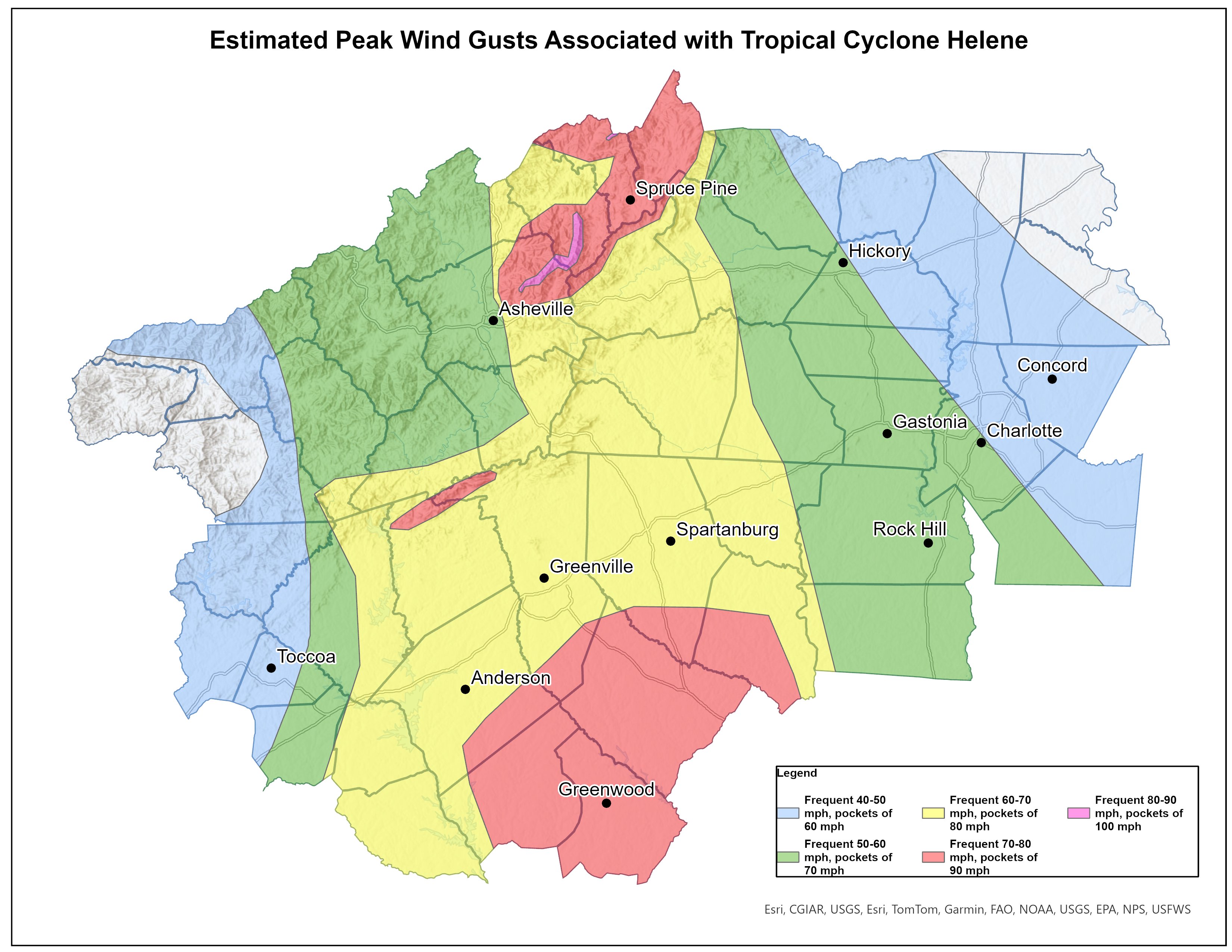
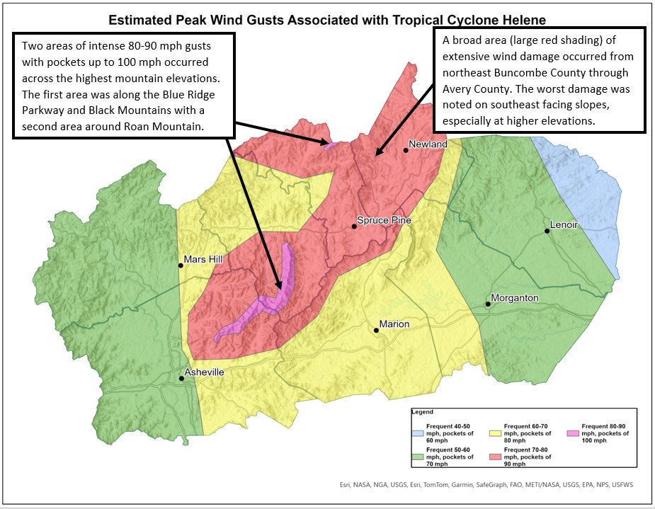
Final wind study from NWS

-
2024-2025 Fall/Winter Mountain Thread
nchighcountrywx replied to Buckethead's topic in Southeastern States
Final wind study from NWS