

dendrite
-
Posts
75,092 -
Joined
2 Followers


About dendrite

Recent Profile Visitors


-

Augdewst 2026: Summer's Last Stand
dendrite replied to Prismshine Productions's topic in New England
Even the wife with the mustache getting wet.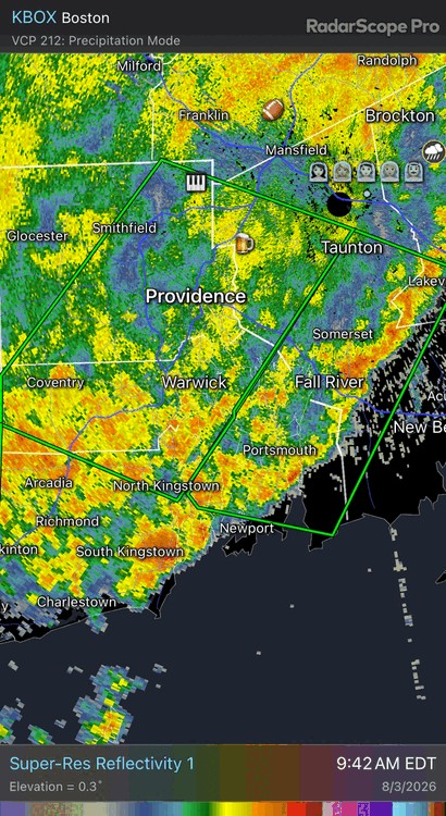
-
Augdewst 2026: Summer's Last Stand
dendrite replied to Prismshine Productions's topic in New England
Scouts crying as their regattas float ashore Block Island. -
Augdewst 2026: Summer's Last Stand
dendrite replied to Prismshine Productions's topic in New England
Is there a badge for filling them? -
Augdewst 2026: Summer's Last Stand
dendrite replied to Prismshine Productions's topic in New England
5.69” in Nashua west of the Everett. -
Augdewst 2026: Summer's Last Stand
dendrite replied to Prismshine Productions's topic in New England
You’ll have a lot of explaining to do if your wife ever reads this forum lol -
Augdewst 2026: Summer's Last Stand
dendrite replied to Prismshine Productions's topic in New England
Flash dating warning -
Augdewst 2026: Summer's Last Stand
dendrite replied to Prismshine Productions's topic in New England
Had to change tblizz’s icon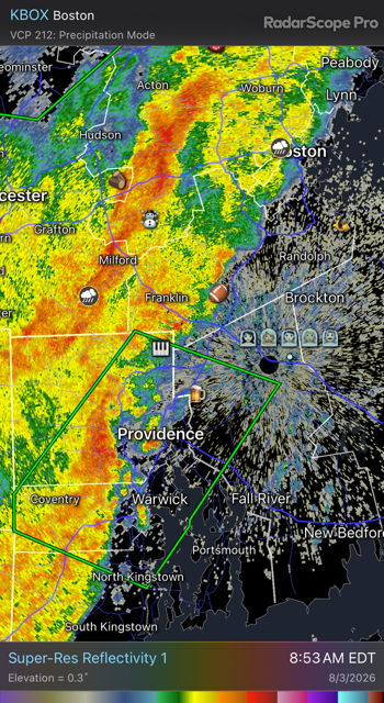
-
Augdewst 2026: Summer's Last Stand
dendrite replied to Prismshine Productions's topic in New England
A couple of 4”+ totals around ASH now. Love to see it. -
Augdewst 2026: Summer's Last Stand
dendrite replied to Prismshine Productions's topic in New England
Dry hands? -
Augdewst 2026: Summer's Last Stand
dendrite replied to Prismshine Productions's topic in New England
Many were pegged with no protection this morning. -
Augdewst 2026: Summer's Last Stand
dendrite replied to Prismshine Productions's topic in New England
Raining again here. I’m satiated. Let’s keep the rest for CT so they can become a rainforest by March. -
Augdewst 2026: Summer's Last Stand
dendrite replied to Prismshine Productions's topic in New England
Yeah that’s my 2.5”. 2.60” now. Seems to be winding down. -
Augdewst 2026: Summer's Last Stand
dendrite replied to Prismshine Productions's topic in New England
Why’s he gotta be like that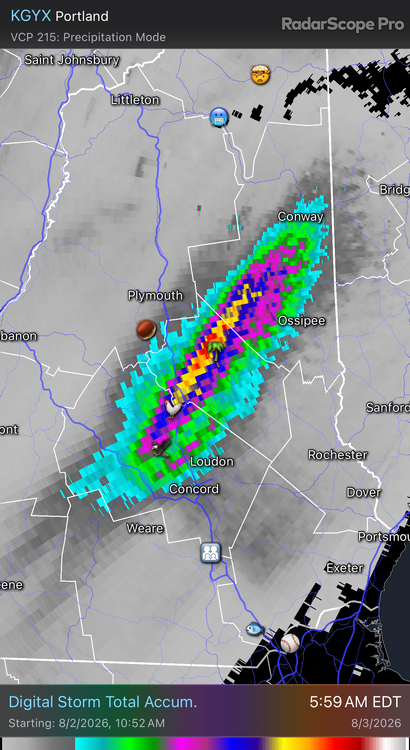
-
Augdewst 2026: Summer's Last Stand
dendrite replied to Prismshine Productions's topic in New England
We’ll see. I just potted up a bunch of pawpaw seedlings the past 2 days. I’m afraid to see if they floated out of their pots. Wish it didn’t have to be so feast or famine. 2.35” and counting -
Augdewst 2026: Summer's Last Stand
dendrite replied to Prismshine Productions's topic in New England
Just got more in 1hr than all of July. It can honestly stop now. Most of this probably hasn’t soaked in.


