

OKpowdah
-
Posts
6,036 -
Joined
-
Last visited
About OKpowdah

- Birthday 03/15/1991
Recent Profile Visitors


-

March 12/13/14 Blizzard/Winter Storm/WWA etc
OKpowdah replied to Bostonseminole's topic in New England
8" more to go apparently -
March 12/13/14 Blizzard/Winter Storm/WWA etc
OKpowdah replied to Bostonseminole's topic in New England
Maybe they were *forecasting* snow including what's on the ground in Amherst...? -
March 12/13/14 Blizzard/Winter Storm/WWA etc
OKpowdah replied to Bostonseminole's topic in New England
Figured this still would go in this thread... Lots of fun tomorrow too. Upstream ML low drops over the Northeast, 500mb temps plummet to around -35C. There's no low level cold advection going on behind this storm. Plus low to mid level moisture gets trapped in the broad circulation formed. We're talking total totals >50, even potentially some low level CAPE >100J/kg. Recipe for heavy snow squalls with whiteout conditions, maybe some thunder..thumb.png.51accb2c750caf820ceac642116664c3.png)
-
March 12/13/14 Blizzard/Winter Storm/WWA etc
OKpowdah replied to Bostonseminole's topic in New England
The upper low is going to give you guys some fun for sure. Especially tomorrow. I mean you even have surface based CAPE tomorrow afternoon. Good recipe for squalls with whiteout conditions. -
March 12/13/14 Blizzard/Winter Storm/WWA etc
OKpowdah replied to Bostonseminole's topic in New England
Parents back in Keene, NH reporting 3.5" total so far -
March 12/13/14 Blizzard/Winter Storm/WWA etc
OKpowdah replied to Bostonseminole's topic in New England
For the sake of my own mental health, I'm so happy I'm living in Oklahoma right now. Because if I was back in Keene, NH for the moats in these past two storms ..... -
OKpowdah changed their profile photo
-
 Definitely has been fun to watch the influence of the Pacific on the pattern recently. All the tropical activity in the western Pacific has had really nice clear impacts downstream, translating to the very strong ridging along the west coast. The biggest change from this week to next week I think is a strong consensus for the negative NAO block to break down. The anomalously high heights over the Davis Straights is projected to erode as the trough over the Great Lakes breaks to the northeast. This is supported by the MJO moving into the E Pac and Atlantic, strengthening the South America hadley cell. The rising NAO would translate to strengthening ridging over the Southeast US. So now let's introduce the forecast problem. This comes about next week, starting around day 5-6 (Sunday 10/27). The effect of both Francisco and Lekima recurving in the next few days is the huge LHR, -PV etc. and another wave packet that reaches the west coast ridge by day 5-6, at which point it rapidly amplifies. Alright so the ridge amplifies, then quickly breaks, but then we run into this problem of the downstream pattern. This week we have a nice -2SD NAO which supports the trough in the eastern half of the CONUS. However next week, the trough that digs downstream of the latest ridge break in the west, will run into rising heights in the SE US with the developing +NAO. So by day 6-7 (Monday), the trough is digging into the four corners region, with cold high pressure behind it. The trough is forced to stay positively tilted with ridging in the west folding over, and the ridging in the SE US preventing the trough from digging toward the southeast. So here's where some model differences arise. Quick model discussion: With this trough, the GFS seems to be able to sweep eastward (then damping out as it's forced north of the SE ridge). The ECMWF however, is quick to form a cutoff over California. The cutoff positively feeds back to the SE ridge, perpetuating the cutoff. The western ridge then spills over into the Plains. A problem might be the ECMWF has a bias to overdevelop cutoff lows in the west, which then pumps up downstream ridging over S-central and southeast US. The CMC is doing the same, and it also has a bias for overamplifying these types of troughs which would result in the same cutoff development. Can also see in the GFS ensembles, there are two areas of large 500mb height spread by day 6-7: 1) Western US on the downstream side of the breaking ridge (where we have our uncertainty with the trough evolution) 2) Over southern Quebec with the increasing height gradient in the developing +NAO pattern. So rather than the nice easy forecast for the CONUS this week (+PNA, -NAO, etc.) we get this fight between the Pacific and Atlantic. Ramifications? Well one of the trickier parts of the forecast is with the arctic high that noses down the east side of the Rockies and the potential for a snow storm in E Colorado with the trough in question. But this uncertainty also builds up eastward with the strength of the SE ridge in question and the latitude of the height/temp gradient over Quebec /New England.
 -
Alaska/Western Canada obs and discussion
OKpowdah replied to patrick7032's topic in Central/Western States
Following the recurvature of Typhoon Francisco, we get a huge jet amplification again in the West Pacific, and it looks like both the GFS and ECMWF want to develop an intense low in the poleward exit region by day 7-10. Could get kinda windy around the Aleutians to western Alaska. -
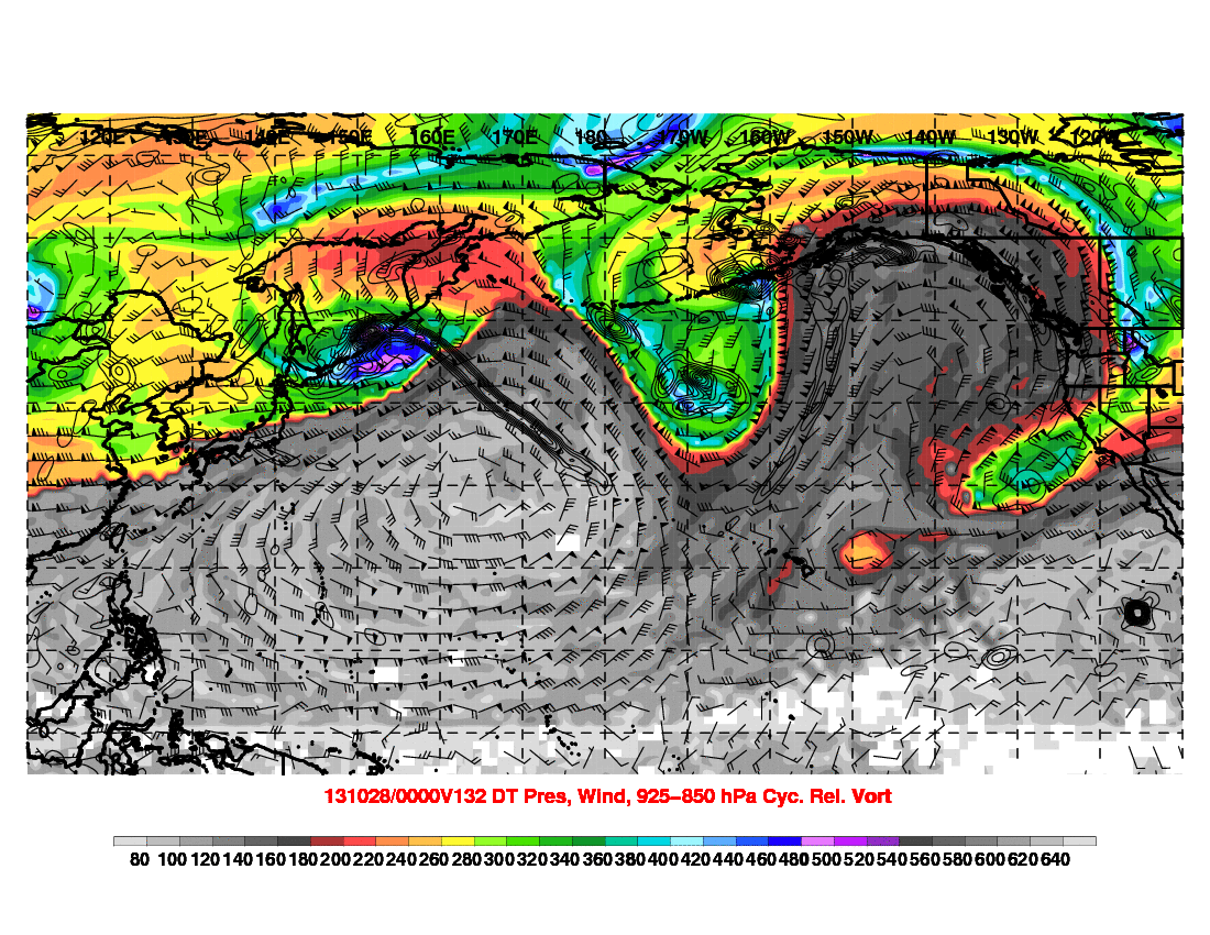
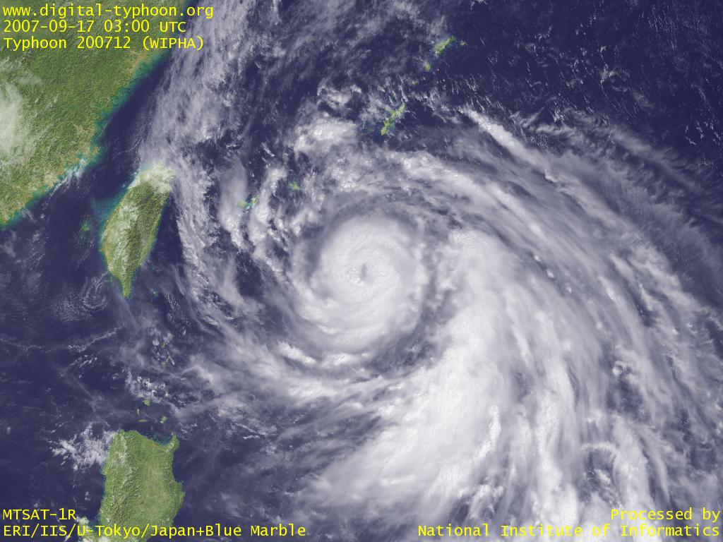 We're watching another potential major Typhoon recurving in the West Pacific, passing close to Japan by day 4 (Tuesday night ET). The story begins though with just some simple extratropical cyclogenesis in the northern Sea of Japan and the amplification of downstream ridging. This ridge eventually breaks as it pinches another downstream disturbance, and then bridges with ridging over the eastern Pacific. The favored superposition of negative PV anomalies develops a very strong ridge on the west coast of North America toward Alaska. As Wipha recurves, distributing upper level latent heat and negative PV downstream, we see a huge WPac ridge form, and a rapid acceleration of the jet. On the poleward exit side of the jet, another extratropical system rapidly intensifies near the Aleutians. As the huge ridge breaks, all the cyclonic vorticity on the poleward side of the jet gets dumped into this system over the Aleutians, forming a pretty stable trough over the North Pacific. Day 5-9 (17th-21st): And so now we have the very distinct pattern of a large trough over the Aleutians and blocking ridge over western North America. As you might imagine, this could have some interesting implications over central and eastern North America, with a negative NAO in place over the north Atlantic. At the very least a period of below normal temperatures, and an opportunity for snow in the Midwest.
 -
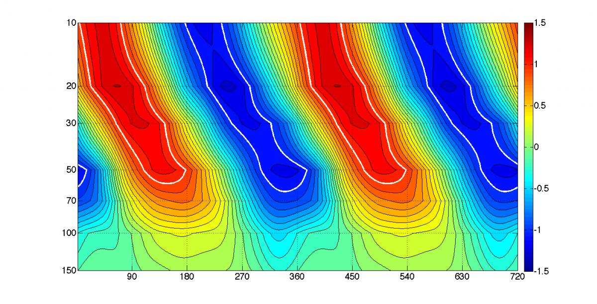 The Quasi-Biennial Oscillation (QBO) is a cycle of zonal wind in the equatorial stratosphere with a period that varies between 24 and 30 months. This oscillation is a product of downward propagating alternating wind regimes. The current method of monitoring this oscillation is through an index, calculated by the zonal wind anomaly at 30hPa averaged along the equator. This method excludes information on the vertical structure of winds in the stratosphere, and presents the QBO as a one-dimensional temporal oscillation. Presented here is a new framework for monitoring the QBO. This framework incorporates both the oscillation in time and in space. The two leading principle components (PCs) of equatorial stratospheric zonal winds are calculated from NCEP/NCAR reanalysis monthly mean data. These PCs are then standardized and used as X and Y coordinates in a 2-dimensional phase space. A phase angle can then be calculated from the coordinates, forming a new index that is much more representative of the state of the stratosphere. The results show a very clear pattern of zonal wind and temperature regimes in the stratosphere. Furthermore, from each of these phases, there are physical connections to characteristics in the troposphere on a monthly to seasonal basis. These include the distribution of tropical cyclone activity, the El Niño / Southern Oscillation (ENSO), and the extratropical pattern. This new framework for monitoring the QBO is shown to be much more applicable to seasonal forecasting. Compare the EOF-constructed oscillation to a 52-month reanalysis segment
 -
The Quasi-Biennial Oscillation (QBO) is a cycle of zonal wind in the equatorial stratosphere with a period that varies between 24 and 30 months. This oscillation is a product of downward propagating alternating wind regimes. The current method of monitoring this oscillation is through an index, calculated by the zonal wind anomaly at 30hPa averaged along the equator. This method excludes information on the vertical structure of winds in the stratosphere, and presents the QBO as a one-dimensional temporal oscillation. Presented here is a new framework for monitoring the QBO. This framework incorporates both the oscillation in time and in space. The two leading principle components (PCs) of equatorial stratospheric zonal winds are calculated from NCEP/NCAR reanalysis monthly mean data. These PCs are then standardized and used as X and Y coordinates in a 2-dimensional phase space. A phase angle can then be calculated from the coordinates, forming a new index that is much more representative of the state of the stratosphere. The results show a very clear pattern of zonal wind and temperature regimes in the stratosphere. Furthermore, from each of these phases, there are physical connections to characteristics in the troposphere on a monthly to seasonal basis. These include the distribution of tropical cyclone activity, the El Niño / Southern Oscillation (ENSO), and the extratropical pattern. This new framework for monitoring the QBO is shown to be much more applicable to seasonal forecasting. Compare the EOF-constructed oscillation to a 52-month reanalysis segment
-
From: Pattern Change and Severe Weather Opportunities
OKpowdah posted a blog entry in Tropospheric Torrent
Source: Pattern Change and Severe Weather Opportunities -
Current Evolution of the QBO and Implications on the Atlantic Hurricane Season
OKpowdah commented on OKpowdah's blog entry in Tropospheric Torrent
Dr. Gray only examined the QBO as measured by the one-dimensional index. There are some issues with that as I've demonstrated in one of my past posts. This takes into account the downward propagating nature of the QBO. As such, I'm able to determine the more favorable stages of the QBO for tropical cyclone activity. I haven't examined any relationship between the QBO and landfalls. Could be interesting. Right now I'm working on a link to favored phases of the MJO -
To start, here's the equatorial zonal wind anomalies so far this spring. Can see the -QBO holding on by its thumbs, with the westerlies starting to descend and near 30mb (first days with a + anomaly since July 2011 WOW) The current profile fits the 330 degree phase of my "index" pretty well. Descending westerlies above 30mb, easterlies centered around 70mb, and neutral right around 30mb. The phase I would be keying in on for hurricane season based on average "residence time" is 60 degrees. Here's the tropopause pressure correlation for phase 60. It's a pretty weak signal, with on average zero correlation in the MDR and negative in the central Atlantic. This may support more disturbances in the central Atlantic more recurvatures of any TCs that do form. (Negative = a higher tropopause height, Positive = a lower tropopause height) Here's the same map for phase 90. Notice the equator to off-equator dipole tightens and intensifies, and the Gulf and NW Caribbean is under a very low correlation (high tropopause height) and that band extends across the Atlantic between 15N and 30N. That dipole that I mention is tightest and most intense around phase 120. So if the QBO reaches phase 90 during the season (essentially a full-blown +QBO), this suggests an increased TC threat in the NW Caribbean and Gulf. Of course this is one factor, and probably still relatively insignificant, but something that's interesting to discuss anyway
-
The big consensus among model guidance at this point is that a piece of energy from the trough over the Northwest Pacific will jump to the Gulf of Alaska by Wednesday morning, then drop southeastward into California Thursday night into Friday. Similar to the last event, there is a weak disturbance in the southern stream that gets ejected out ahead of the trough dropping into the Southwest ... and able to lift northeastward as the polar vortex over southeast Canada retreats poleward. So the result is some moisture return ahead of the disturbance Wednesday and Thursday ... maybe some rain too, but let's not get carried away. The real differences between the GFS and CMC and ECMWF is with the handling of the individual impulses within the western trough. CMC and ECMWF like swinging the lead impulse into eastern Colorado Saturday afternoon. Amplitude, tilt, and timing of this particular piece of energy will be crucial. At this point, the projected evolution brings a warm front through Oklahoma on Saturday with round 1 of thunderstorm potential, and a surface low developing in eastern CO. The ECMWF and CMC deepen this surface low into western Kansas Saturday night ... really pretty awesome placement for OK. Euro increases CAPE substantially Saturday night. The cold front catches the dryline sometime Saturday night into Sunday morning for round 2 ... so timing is an issue, but verbatim this would no doubt be a significant overnight event. The trough continues eastward with that primary upper level impulse sharpening over the southern Plains, and the surface low intensifying across the central Plains to Midwest, introducing severe threats for Sunday and Monday for the Dixie Alley area.
.png.97aa115364742253434c828acaf4f707.png)

