All Activity
- Past hour
-
I still believe this winter will be kinda similiar to last winter.It should start out warm and wet as the potential for a -IOD as we get into severe fall.The MJO right now is fixing to creep along the IO the next several days with a potential strong EWB,this abide should strengten NINA upcoming
.thumb.png.1cd86810af615a880bc726cfe934097c.png)
-
It happens to me a lot. I tend to start heading ESE around 6 as my customers close so I'll often chase, or be chased by, storms as they work this way. It's a real hoot in the winter as a front is working down and I can watch "the wall" behind me in the mirror. I dunno what juicy, window splattering, paint wrecking, headlight blocking insect-like critters they are but I can tell you that they suck.
-
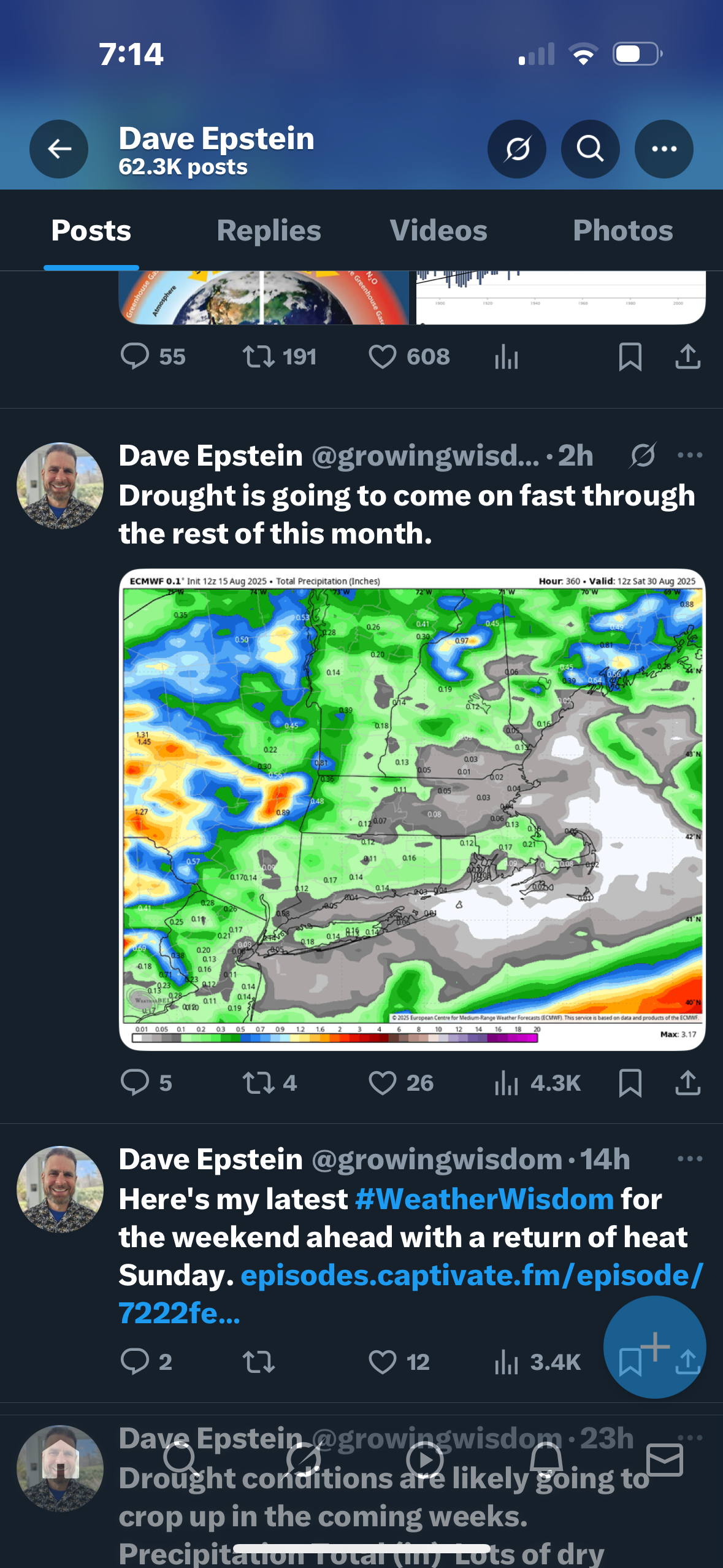
It is never going to rain again. All the grass around is dead deed dead.
-
Always happy for our boy
-
lfg
.thumb.png.8805cd2bedeacfa739bf5674c37dc1a7.png)
-
Flash - bang!! Love it.
-

Hurricane Erin - 75 mph - 993 mb - WNW @ 17
WxWatcher007 replied to BarryStantonGBP's topic in Tropical Headquarters
981.4mb extrapolated -
obligatory la-la land Savannah hit on 18z gfs ...always one per year

-
He’s getting hard, fast ..
-
Looks pretty kewl, thanks for sharing.
-
Hurricane Erin - 75 mph - 993 mb - WNW @ 17
WxWatcher007 replied to BarryStantonGBP's topic in Tropical Headquarters
Right. I’m guessing the central pressure has dropped a few mb since then. This looks primed to take off now. -
Some mexico city views for my fellow heads, fresh snow on the volcanos most mornings, melts off popo (active) during day. Managed a killer hike up into the national park, snow level looked about 16k (summits 17k+) Weather here is incredible this time of year, highly rec View of fresh snow on summit morning after our hike Pyramids also extremely sick S tier food obv Ready for a bit more storm action in the Midwest and ready for fall
-
2025 Atlantic Hurricane Season
WxWatcher007 replied to BarryStantonGBP's topic in Tropical Headquarters
I’ve been sold all year on the SW Atlantic being the seasonal hot spot. Erin was the first real test and we’re seeing how that’s likely to go… This won’t be the last time the east coast is watching a major imo, but waves actually have to get to that part of the basin first. -

Hurricane Erin - 75 mph - 993 mb - WNW @ 17
Wannabehippie replied to BarryStantonGBP's topic in Tropical Headquarters
986mb on first pass of latest recon -
Hurricane Erin - 75 mph - 993 mb - WNW @ 17
WxWatcher007 replied to BarryStantonGBP's topic in Tropical Headquarters
Recon approaching for another center pass. We’ll see just how quickly this is intensifying shortly. -

2025 Atlantic Hurricane Season
LongBeachSurfFreak replied to BarryStantonGBP's topic in Tropical Headquarters
Heading into peak with above normal water temps in all but the far east MDR anything is possible. -
Cedar Rapids getting smoked pretty good
-
big 'un on the wild 18z gfs

-
IF that happens, the seasonal ACE would reach ~34 as of 8/22. If then another multiday hurricane were to closely follow Erin like the GFS/GEFS are suggesting could occur, having 50ish ACE by the end of August would be a reasonable possibility especially considering there could easily abe an additional weaker storm or two, which would out 2025 notably above the normal ACE through August.
-
Greensboro was swimming in it last July
-
"It's dead Jim" Latest one has it as 0/0.
- 42 replies
-
- 1
-

-
- lower texas coast
- ne mexico
- (and 3 more)
-

2025 Short Range Severe Weather Discussion
hawkeye_wx replied to Chicago Storm's topic in Lakes/Ohio Valley
Models did a terrible job forecasting this. The HRRR literally had nothing making it to eastern Iowa only a few hours ago. The RRFS had something small passing across northeast Iowa. -
It’s getting dark in the N sky here and the radar says strong thunderstorms are on the way as an outflow boundary is coming through: SPECIAL WEATHER STATEMENT NATIONAL WEATHER SERVICE CHARLESTON SC 635 PM EDT FRI AUG 15 2025 GAZ118-119-SCZ047-051-152330- COASTAL CHATHAM GA-INLAND CHATHAM GA-COASTAL JASPER SC-INLAND JASPER SC- 635 PM EDT FRI AUG 15 2025 ...A STRONG THUNDERSTORM WILL IMPACT JASPER AND CHATHAM COUNTIES UNTIL 730 PM EDT... AT 635 PM EDT, DOPPLER RADAR WAS TRACKING A STRONG THUNDERSTORM NEAR BELLINGER HILL AREA, MOVING SOUTHWEST AT 15 MPH. HAZARD...WIND GUSTS UP TO 50 MPH AND PENNY SIZE HAIL. SOURCE...RADAR INDICATED. IMPACT...GUSTY WINDS COULD KNOCK DOWN TREE LIMBS AND BLOW AROUND UNSECURED OBJECTS. MINOR DAMAGE TO OUTDOOR OBJECTS IS POSSIBLE. LOCATIONS IMPACTED INCLUDE... POOLER, BLUFFTON, HUTCHINSON ISLAND, DOWNTOWN SAVANNAH, BELLINGER HILL AREA, SAVANNAH INTERNATIONAL AIRPORT, GODLEY STATION, WILMINGTON ISLAND, GARDEN CITY AND PORT WENTWORTH.
-

2025 Short Range Severe Weather Discussion
Chicago Storm replied to Chicago Storm's topic in Lakes/Ohio Valley
debt repayment has been completed. final total paid...5 years. -
2025 Short Range Severe Weather Discussion
hawkeye_wx replied to Chicago Storm's topic in Lakes/Ohio Valley
Holy cow, what a storm! This reminds me of the derecho. It briefly poured half-inch size hail, then 70 mph wind blasted through. I couldn't even see the houses across the street. Thankfully, our hail was only half-inch size. A spotter only a mile away reported ping-pong ball size.

.png.ccdc638214d89d85fbd7058775177c73.png)


.png.993c3e65baa5cf9db92dc3425d84ef86.png)