All Activity
- Past hour
-
Some major damage over the weekend in parts of the area it seems. Saw big branches and debris along I-70 from PA into Maryland. Looks like things will be relatively quiet - maybe a window for some strong storms next Tue or so.
-
The sun has somehow begun to periodically find its way through the cloud factory of Frederick’s valley.
-
Friday night / early Saturday looks like some showers nothing heavy or soaking
-
Agreed, I hope Snowman19 is right. I’ll gladly roll the dice with ENSO neutral.
-
-
Beautiful! Spring is here! Being off the devices and outside is good for the soul. I’ve been more or less off the site for months and I’ve loved it. Kinda wish I knew what happened though.
-

Central PA Spring 2025
Itstrainingtime replied to canderson's topic in Upstate New York/Pennsylvania
Thank you Jon. I'm fortunate that I got on antibiotics right away. I already feel somewhat better just 2 days after diagnosis. -
Another F here, but we’re on to spring. Great graphics as always. I know that’s a lot of work.
-
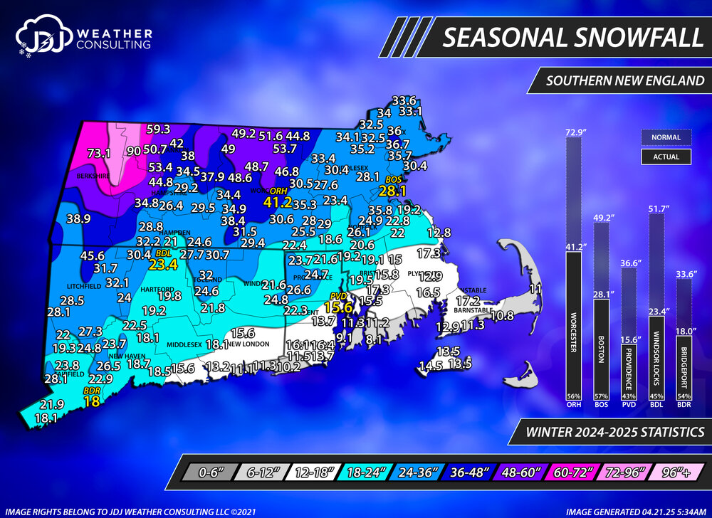
Final seasonal snowfall totals for the 24-25 season. I added some stats on the side for the climo sites and compared them to normal.
-
Winter 2024-2025 All Snowfall Totals Maps (CT/SNE)
The 4 Seasons replied to The 4 Seasons's topic in New England
Update for the 24-25 season totals FINAL. -
It can rain all it wants. I just need it to not be between 6-10a.
-
Just finished the final seasonal snowfall map for the 24-25 season. I added stats to the side for the climo sites as well as a progression throughout the season which you can see on our site. Everything is updated in the 24-25 snowfall maps page.
-
Depends on the plume type. If it's water vapor, we might have additional warming. If it's SO2, then cooling. However, the plume type might not mean much if the eruption is weak. Also, the effects aren't definitive either.
-
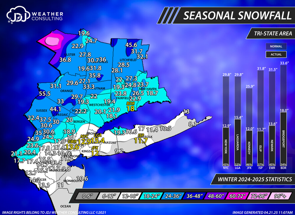
Winter 2024-2025 All Tri-State Snowfall Totals Maps
The 4 Seasons replied to The 4 Seasons's topic in New York City Metro
Updated for 24-25 season snowfall final totals. CT/SNE/Tri-State/Northeast maps on our site as well as snowfall progression throughout the season and statistics for climo sites. -
The sun is starting to come out here and I see large patches of blue skies everywhere.....
- Today
-
I see very little chance for El Niño at this point. The only thing that I recall that ever explicitly hinted at it was CANSIPS a number of months ago when looking ahead to August showing a significant central Pacific equatorial warming. However, it has since been modifying this each run and no longer shows anything of note. In addition, Nino regions have cooled notably from highs in March/earlier this month (see below). When also considering the Euro’s notable warm bias in spring for the subsequent autumn, I’d also say very low chance. La Niña may very well have a better chance than El Niño.


-
Had a really nice easter Sunday yesterday. Spent a lot of it outside. Tree pollen was high so I reached for a 24hr Zyrtec at midday (a rarity for me). Grateful for the lack of mosquitos. I guess they haven't had a chance to breed yet. However, those gnats that try to land in your eyes were plentiful. Oh, well.
-
Os are 0-5 when Morton starts. 9-7 with anyone else. Time to move on from Morton. I'm assuming we will be subjected to atleast another month of this. Maybe more.
-

2024-2025 La Nina
so_whats_happening replied to George001's topic in Weather Forecasting and Discussion
Latest subsurface look, lets see how things go from here..thumb.gif.5e777245b51533e229f4bbdebfbaa9de.gif)
-
I personally already like the look for next winter for the simple fact that the worst case scenario for winter here (strong El Nino) appears to be the least likely scenario for 2025-26. Multiple other things going in our favor too, but not going to get into details this early. Also, a reminder to all that there is a 2025-26 discussion thread.
-
0.25" of precip this morning. A little snow was mixed in (around 0.1" on the grass). Wet, chilly morning.
-
Struggling to get to 60 so far here. 59.9 on my station with light winds and thick cloud cover.
-
Jesus, sorry to hear Mike. That is what about to me out last year, but it went undiagnosed/untreated for 5 months Hope you feel better soon
-
1 inch+ of rain on Saturday does not really equate to an upcoming steining.
-
I'm planning on the 20% reduction of amplitude that seems to always be a necessary correction in the mid range to pull us back just over the tolerability threshold. It looks like a fropa with the vorticity smearing out N of us. there's are also some reasoning related to GFS specific biases to erode warm heights too much out in time but... it's all negotiable.


.gif.578e386dde5aae97931dca9a258fa39f.gif)


