All Activity
- Past hour
-
Chester County PA - Analytical Battle of Actual vs. Altered Climate Data
chubbs replied to ChescoWx's topic in Climate Change
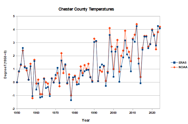
There is complete agreement on Chester County's climate between NOAA and ERA5 reanalysis. A big feather in NOAA's cap because the two series are independent, different data and methods. -
I’m referring to the precip in western Pa which has a different trajectory. Hopefully when it arrives it’s just a few showers.
-
Agreed. There was a nice batch of rain out near Scranton but the bulk of it is going to my north, I just getting clipped by the southern edge. Time will tell what happens with that batch out in western PA.
-
I dunno radar kinda looks like shit. Most is drifting way north, and even the (admittedly absolutely horrific) hrrr shows most stuff staying to the north with the exeption of some popup showers.
-
-
It’s a pretty strong ensemble signal from a week out.
-
It has to break sometime, but we’ve been kicking the can a bit on it. There’s been too much cold lingering in S Can. But yeah, around that time it looks like the cold starts to get choked off up to James Bay. Hopefully we flip a switch mid month.
-
47 degrees and a thunderstorm this morning. 0.23” of rain so far. Appears like the heavy rain is going to stay to the west of us.
-
We will because winter is over
-
Records: Highs: EWR: 83 (1985) NYC: 80 (1928) LGA: 74 (1989) JFK: 73 (1988) Lows: EWR: 23 (1995) NYC: 20 (1874) LGA: 25 (1995) JFK: 24 (1995) Historical: 1815: The Tambora Volcano in Java began erupting on this day. A few days later on the 10, Tambora produced the largest eruption known on the planet in the last 10,000 years. Ash from the volcano would circle the globe, blocking sunlight and leading to the unusually cold summer in 1816. On 6/6/1816, snow would fall as far south of Connecticut with some places in New England picking up 10 inches. On July 4th, 1816, the temperature at Savannah GA plunged to 46 degrees. Eastern North America and Europe had freezing nighttime temperatures in August. 1936: Approximately 454 people were killed in the second-deadliest tornado outbreak ever in U.S. More than 12 twisters struck Arkansas to South Carolina. An estimated F5 tornado cut a path 400 yards wide through the residential section of Tupelo, Mississippi. At least 216 people were killed, and 700 were injured. The tornado had a 15-mile long path and did $3 million in damage. One of the survivors in Tupelo was a baby of an economically strapped family who had an infant they'd recently named Elvis Aaron Presley. Gainesville, Georgia had at least 203 fatalities and 934 injuries from an estimated F4 tornado that occurred early the following morning. 1945 - The temperature at Eagles Nest, NM, plunged to 45 degrees below zero to establish an April record for the United States. (Sandra and TI Richard Sanders - 1987) 1955 - The Northern Rockies and the Northern High Plains were in the midst of a four day storm which produced 52 inches of snow at Lead, located in the Black Hills of western South Dakota. (David Ludlum) 1972 - A tornado, 500 yards wide at times, touched down at a marina on the Oregon side of the Columbia River, and then tore through Vancouver WA killing six persons, injuring 300 others, and causing more than five million dollars damage. It was the deadliest tornado of the year, and the worst of record for Washington. (The Weather Channel) 1982 - An unprecedented April blizzard began in the northeastern U.S. One to two feet of snow fell across Massachusetts and Connecticut, and up to 26 inches was reported in Maine. New York City received a foot of snow. Winds reached 70 to 80 mph during the storm, and the storm also produced numerous thunderstorms, which contributed to the heavy snow. (Storm Data) 1987 - A storm produced unprecedented April snows in the central Appalachians. Mount Mitchell NC received 35 inches of snow, and up to 60 inches (six feet) of snow was reported in the mountains along the border of North Carolina and Tennessee. The total of 25 inches at Charleston WV easily surpassed their previous record for the entire month of April of 5.9 inches. The 20.6 inch total at Akron OH established an all-time record for that location. (Storm Data) (The National Weather Summary) 1988 - Thirty-nine cities across the eastern half of the country reported record high temperatures for the date, including Saint Louis MO with a reading of 91 degrees. Laredo TX was the hot spot in the nation with an afternoon high of 100 degrees. (The National Weather Summary) 1989 - Unseasonably hot weather prevailed in the southwestern U.S. Afternoon highs of 100 degrees at Santa Maria CA and 105 degrees in Downtown Los Angeles established records for the month of April. (The National Weather Summary) 1990 - Afternoon and evening thunderstorms developing along a cold front produced severe weather in southern Oklahoma, southern Arkansas, and north central and northeastern Texas. Thunderstorms spawned a dozen tornadoes in Texas, including one at Fort Worth which caused a million dollars damage. There were nearly one hundred reports of large hail and damaging winds. Thunderstorms in Texas produced hail three and a half inches in diameter west of Fort Worth, and produced wind gusts to 80 mph at Cross Plains. (The National Weather Summary) (Storm Data)
-
It will be interesting to see if we can actually get a slow moving coastal next weekend since that storm track has been almost nonexistent in recent years.
-
Radar truth says otherwise. We have seen the models off by a 100 miles. I’m routing for a dry day, I just don’t see how we escape that much precip incoming.
-
55 / 37 and cloudy. Rain, showers throughout the day with the heaviest staying north. Similar Sunday and Monday with 0.50 - an inch in the heavier spots of rainfall through Monday morning. Trough into the northeast for an overall cooler period 4/8 - 4/14 with the next shot rain Friday into next weekend. Cut off mid month looks less intense on the last 2 days of data and a gradual warm up should follow next weekends unsettled weather, although no major sustained much above normal temps look likely through the next 10 days - 2 weeks. https://cdn.star.nesdis.noaa.gov//GOES16/ABI/SECTOR/NE/GEOCOLOR/GOES16-NE-GEOCOLOR-600x600.gif
-
So was Stu Gotz in Pawtucket
-
Becoming pretty confident that we do not see an El Niño. The PMM has become severely negative (cold water off of Baja). -PMM argues very strongly against Nino development. My best guess right now is La Nada/neutral and most likely cold-neutral
-
wishcast_hater started following April 2025 Discussion/Obs
-
It’s all going North. Not much forecast for NYC today.
-

E PA/NJ/DE Spring 2025 Obs/Discussion
Albedoman replied to PhiEaglesfan712's topic in Philadelphia Region
well, I am clearly disappointed that we missed out on all the significant rain again this morning. The fronts hanging up over the mid south and to the NW of our area just will not allow any GOA moisture to get up here. Light rain showers are not going to cut it for ending this drought. Sundays t-storms rains chances with heavy rain are dying as I write. The dry cold winds also return with a vengeance. We are screwed from Monday on with Tuesday feeling like winter and the heater on full blast. Would not be surprised to see flurries/graupel in the LV. I am tired of being teased. Incredible how the Memphis TN area nearly gets a foot of rain and we cannot even squeeze out a popcorn fart of decent precip. -

Central PA Spring 2025
Mount Joy Snowman replied to canderson's topic in Upstate New York/Pennsylvania
Low of 54 with .01” of rain. -
2025-2026 ENSO
PhiEaglesfan712 replied to 40/70 Benchmark's topic in Weather Forecasting and Discussion
I think we are seeing this with el ninos. The last moderate one was 2002-03, which is over 20 years ago now. Since then, either they've been weak (2004-05, 2006-07, 2014-15, and 2018-19/20) or strong/super (2009-10, 2015-16, and 2023-24). That doesn't seem to be the case with la ninas. We just had 3 straight years of moderate la nina in 2020-23. - Today
-
Sorry but LOL at that map with 1.35 over me. More like 0.135
-
It's probably time for Elias to go. He generally refuses to spend to add proven talent to the core young talent even though ownership gave him the go ahead. He gets a lot of credit for changing the fortunes of the franchise through scouting and player development etc, but he seems literally stuck in that mode.
-
Our Home Depot yesterday already had a huge shipment of summer annuals and people were buying them left and right. They better not put them in the ground this weekend! Cloudy and 60
-
Stuff is starting pop. Forsythia, those prickly green underbrush in the woods are greening , red maple buds swelling like morning weenie over Ray’s face.. grass greening


