All Activity
- Past hour
-
We are in more of a La Nina pattern right now. This started in May 2024. A good indicator is the ENSO subsurface, when there is below average water at -200m (the thermocline), below Nino 3/3.4, that translates to more of a La Nina pattern. Right now the indicator is weakish La Nina, where it's been for 14 months. The long term Hadley Cell state in the Pacific Ocean is also La Ninaish.
-
0z GFS is a inch plus for you! congrats!
- Today
-
It was a gorgeous day. Why not enjoy the day if you get that chance? I’m jealous!
-

2025-2026 ENSO
Stormchaserchuck1 replied to 40/70 Benchmark's topic in Weather Forecasting and Discussion
It was kind of a La Nina pattern this past Winter, and last year starting in about May. That's why it was so dry.. do you remember how it rained like not at all last Summer in the Northeast, and was hot? That's usually a La Nina pattern. The Winter somewhat fit it too, being cold and dry. I've correlated the ENSO subsurface with better pattern conditions than surface SSTs.. and the subsurface has been in La Nina range pretty much since February 2024. Even now, it's still weakly La Nina in the central subsurface. -
It looks like the 00z models generally have that storm, and maybe not much else. So bring on the summer storms!
-
 craigieweather joined the community
 -
I would rather find a way to capture that water vapor so it can be converted to clean drinking water.
-

E PA/NJ/DE Spring 2025 Obs/Discussion
snowwors2 replied to PhiEaglesfan712's topic in Philadelphia Region
39°/42° today!
-
I was joking about the year without summer. That's obviously never happening again especially without a volcanic eruption.
-
The long hot days will drag on seemingly forever, before our brief respite of shorter days and longer nights return once again. Life in the subtropics of the MA.
-
Bored with baseball already. 2 days until the NFL draft. 11 picks. Trade up, trade down, trade Andrews? LFG Ravens!
-
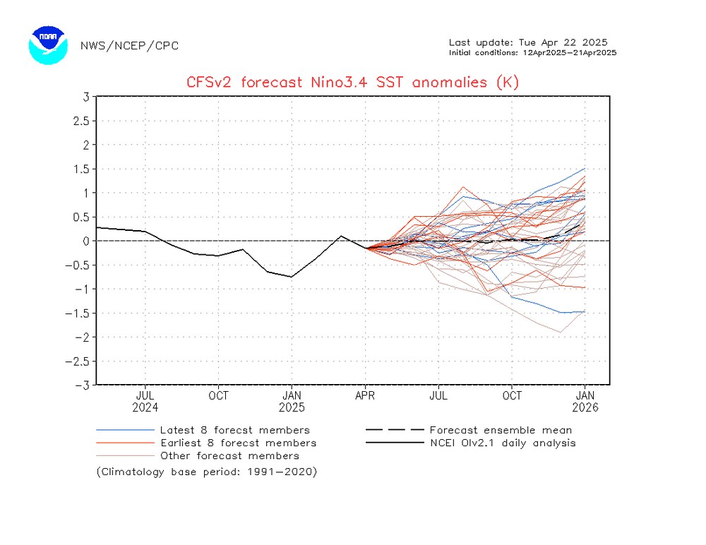
Since that mid April IRI 3.4 projection model summary was released, the CFS 3.4 progs have cooled significantly. It had had (per what I bolded above) +0.62 in OND and was still rising. Now, based on the image below, OND is only ~+0.05. So, any chance that there had been for weak El Niño (though only small), which had been based on the +0.62 in OND, is even smaller by a good bit. I’m saying that as of now the chance for a weak El Niño has dropped to extremely low. I won’t say near zero yet only because it’s too early. But I’m probably at 5-10% at most. 4/22/25 Nino 3.4 CFS run: OND only +0.05 @jburnsplease pin this thread and unpin El Niño 2023-2024. That one is just a bit outdated.
-
im up by then so I hardly notice
-
I keep ‘em closed at night. As a certified insomniac, the sound of the birds screeching at 5am is enough to drive me mad. I don’t understand why they feel the need to cause such a ruckus at the ass crack of dawn everyday. Whatever they’re discussing at that ungodly hour couldn’t possibly be so urgent!
-
good weekend to have the windows open.. no install needed
-

E PA/NJ/DE Spring 2025 Obs/Discussion
Albedoman replied to PhiEaglesfan712's topic in Philadelphia Region
After being criticized by an individual for not taking a chill pill and for saying the mulch fire was major fire and that I was blowing the fire possibilities out of proportion with the current drought in the last few days, two so called non-major wildfires are still going crazy. Jim Thorpe area over 500 acres and now another non major fire in southern NJ. All I hear now is crickets at my house. Also Mike Gorse, I must apologize to you and your staff as I did not mean any disrespect toward you or your staff at MT Holly. I am really frustrated with this crappy weather pattern we are stuck in for the past 9 months and did not mean to take it out toward MT Holly staff. Many of the old weather hobbyists have to be as frustrated as I am too as these daily 20-30 mph Santa Ana type winds with extreme diurnal temp ranges and no Gulf of America moisture source for storm convection which has basically has been gone for nearly a year now. I am also hoping a special weather statement will be issued that considers the under-stories in the woods and nearby brushy fields are extremely dry right now regardless of any rain we received two weeks ago. The dry warm winds are sure not helping as evident by these fires. Thanks https://www.foxweather.com/extreme-weather/jones-road-wildfire-new-jersey-shore-smoke-evacuations https://www.inquirer.com/news/pennsylvania/jim-thorpe-pennsylvania-wildfire-20250422.html -
People in Killingly CT have been complaining about swarms of them so bad they can't spend time outdoors.
-
thats exactly why you need a whole home multistage filter (one of many reasons).
-
we're going to have to learn how to pump that shit into outer space. They did a whole thing on ABC today for Earth Day about a certain kind of sand that absorbs CO2. If sand can absorb CO2 and remove it from the air, then we can also pump excess water vapor into outer space. Get rid of two greenhouse gases at once.
-
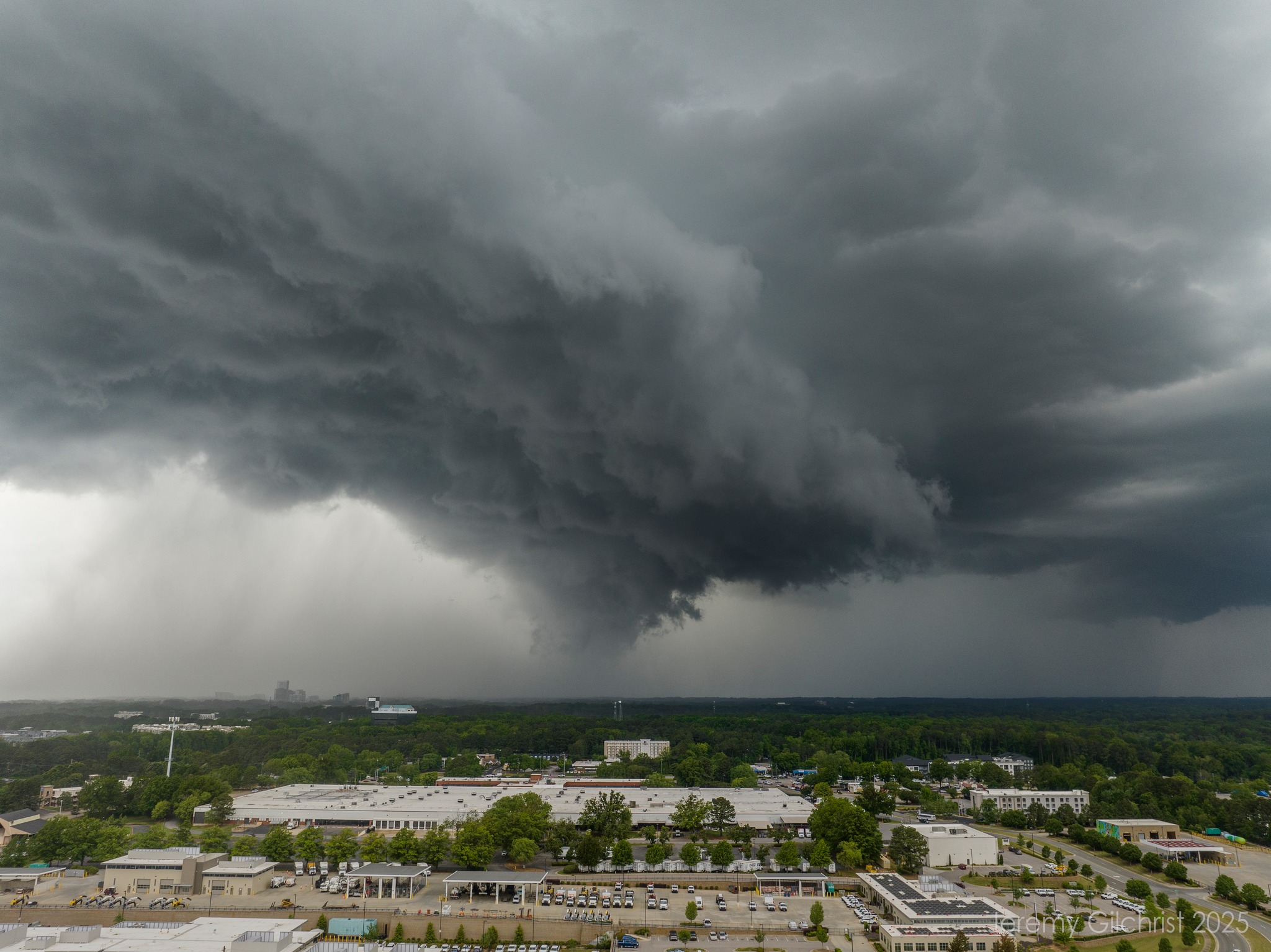
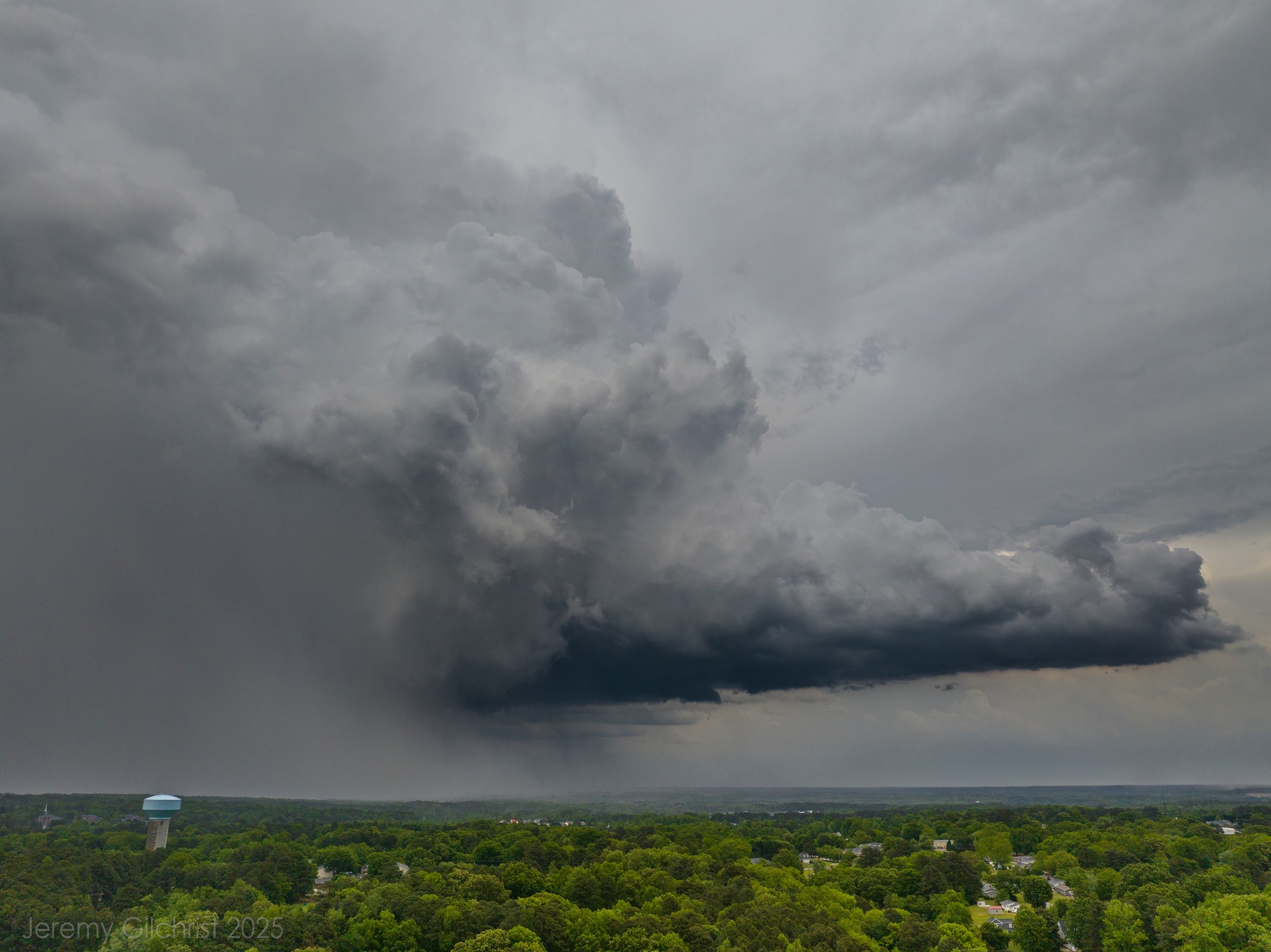
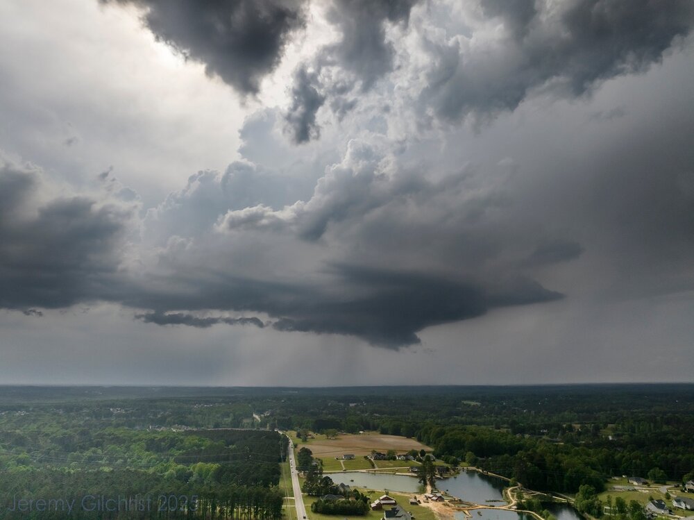
wow this is absolutely amazing, I saw it too, in the northwest. you took this image with your cell phone?
-
I did! I was on two different cells actually. The first pic here is McGee’s Crossroads (east of Angier) and the other from off Capital Blvd in North Raleigh. This last image is as the cell in Raleigh moved off the ENE (Rain/hail separated from the updraft)


-
Pitching is bad, but this isn’t much better: Henderson .213 avg. Holliday .213, Rutschman .200, Westburg .187. Mountcastle .229, O’Neill .230
-
Has a team ever gone from worst (2021) to best (101 wins in 2023) and back to the bottom again 2 years later? Our pitching is historically bad right now. And offensively we're just maddeningly inconsistent.
-
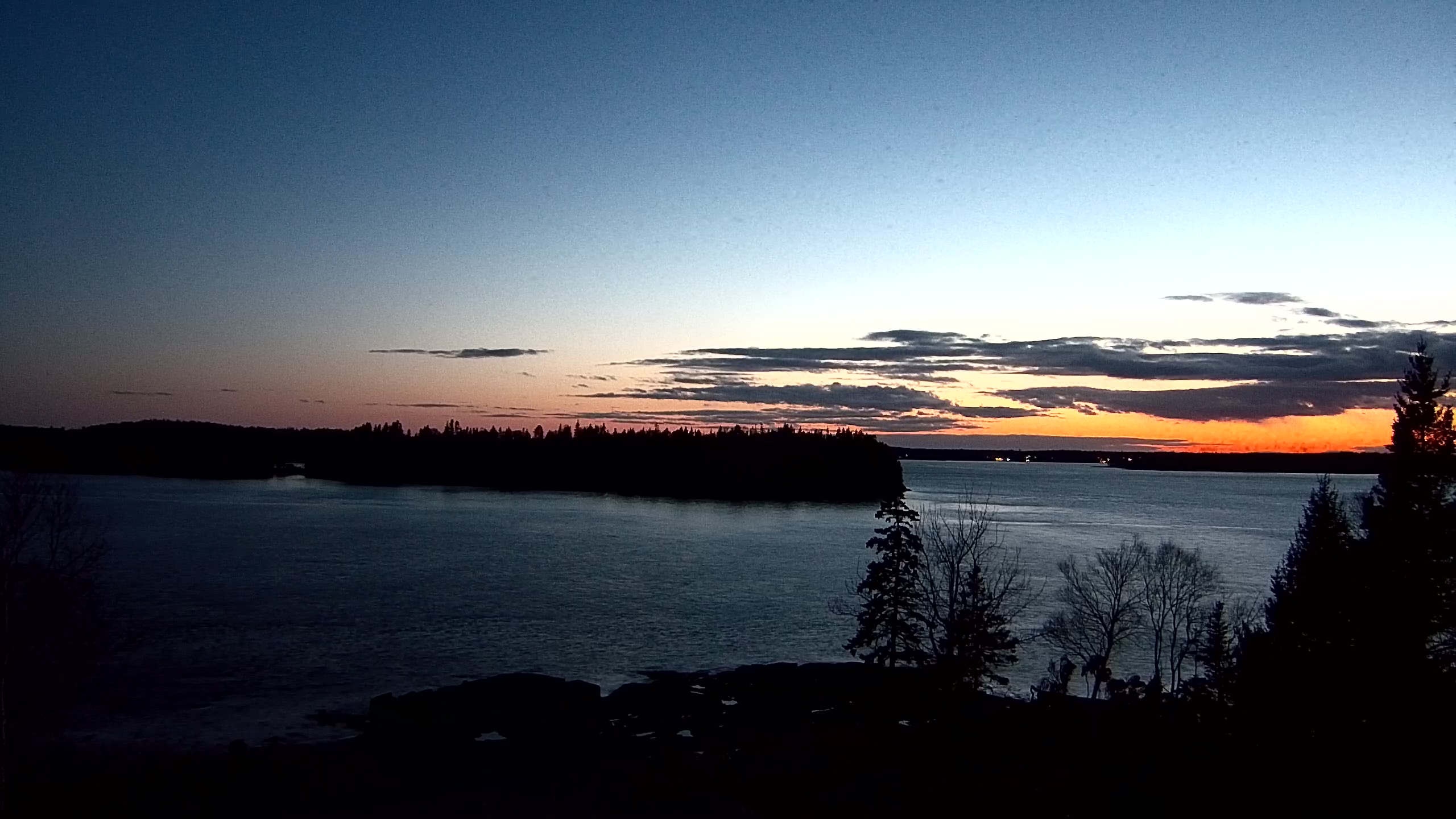
I can still faintly see light in the western sky after 9pm! Long days are upon us.
-
2025 Atlantic Hurricane Season
Stormchaserchuck1 replied to BarryStantonGBP's topic in Tropical Headquarters
Actually it's been cooling pretty nicely lately.. we might have Neutral-negative ENSO vs Neutral-Positive, which is the difference of about 1.0-1.5 more named storms/year (last season was Neutral-negative). -
The 8 extra base hits that Kremer allowed were the most ever by a starting pitcher in team history. That’s amazing. The starters ERA is now 6.22 for the season.