All Activity
- Past hour
-
I wish
-
SLK has done 31F to 76F before noon.
-
78F at 11:54am. A 42-degree rise before noon is impressive even here in the Mtn valley.
-
75.5°
-
10:1?
-
Ha! True-I was comparing to yesterday...but yeah windy as hell...Sunday was gusting to at least 40
-
Windier? Its been windy for at least the last 9 years...
-
1 to 2 on the Icon for SNE
-
12z ICON cancels the weekend
-
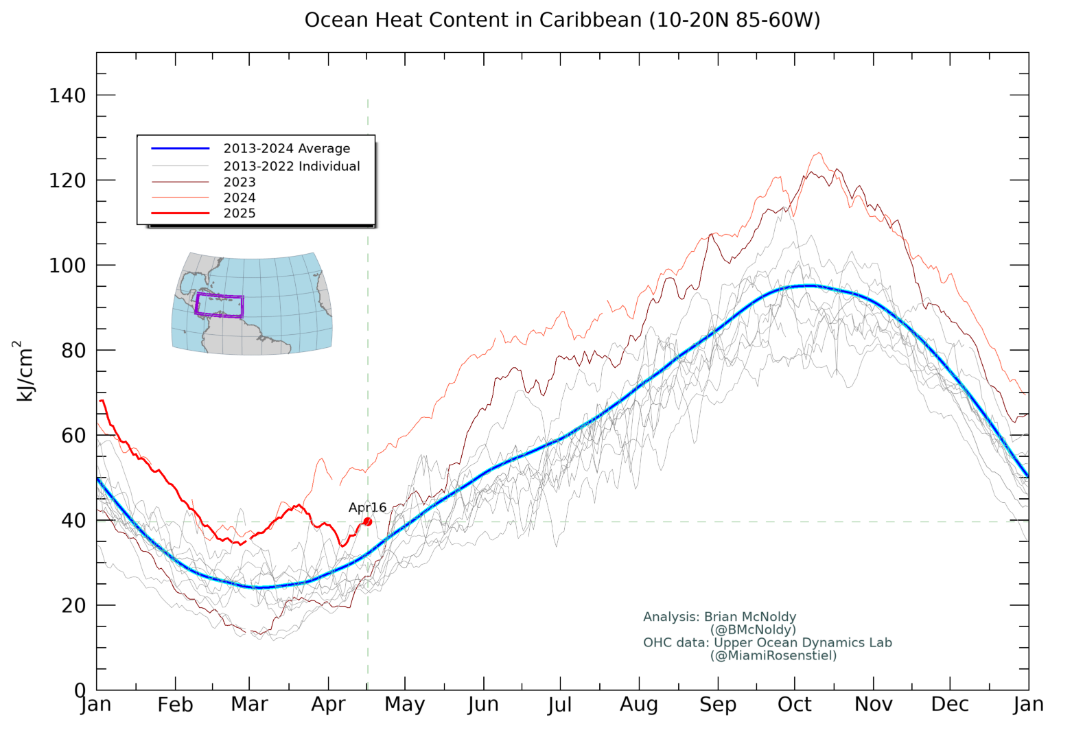
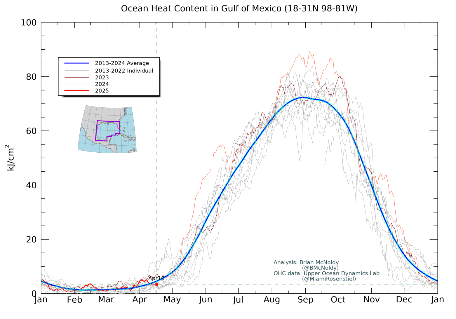
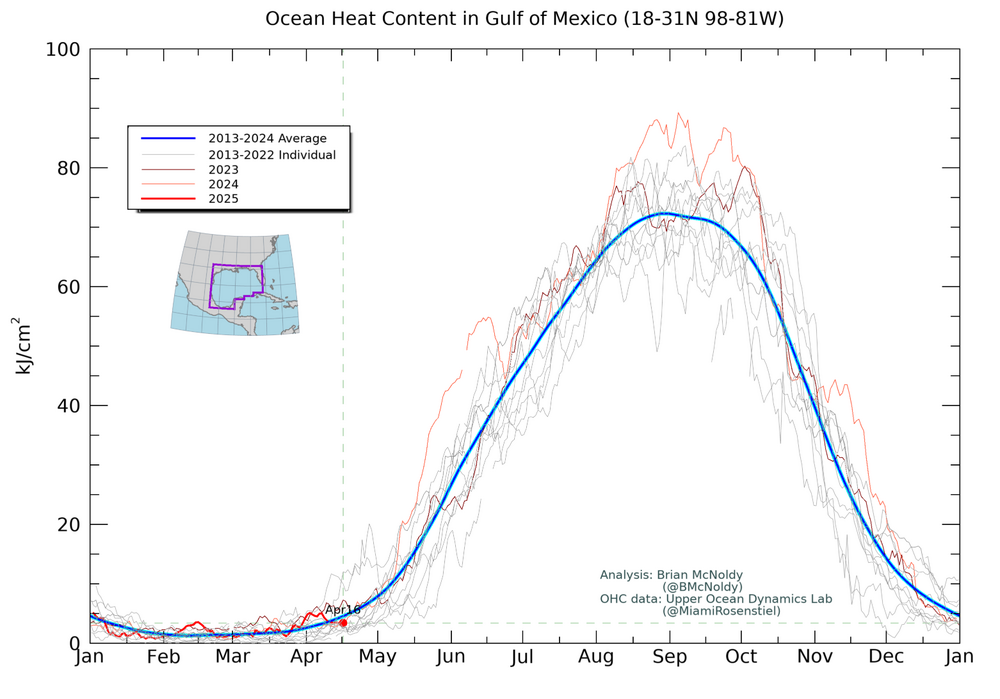
The Caribbean OHC was still AN as of April 16th, but not as warm as a year ago: The Gulf was NN as of 4/16/25 but that was actually near 4/16/24:
-
Barry, You’re twisting my words. I didn’t say the MDR is cold. You can look back ITT and see that. What I said is that the tropical Atlantic isn’t nearly as warm as last year at this time (OHC and SST) and is close to normal. I didn’t forecast how that will be come H season, but I did imply that the Euro forecasting a near 30 year average season instead of well above like it did in 2024 was heavily influenced by that. I also said the Euro might be a bit underdone with NN. I personally feel the best chance is still for above average in 2025 and near to above average activity for the CONUS, but likely not as active for the CONUS, itself, as the terrible 2024 since the odds would favor not as bad.
-
90mpg gust down in Springfield, MO. Storm packing some heat
- Today
-
36mph max gust so far at the campus weather station, which is pretty impressive as the anemometer is only 10ft off the ground
-
Last year when we heard them, we legit thought a baby was being tortured. Like almost called the cops level…
-
is that precip or temps?
-

Plains States Observations and Discussion Thread
Chinook replied to lookingnorth's topic in Central/Western States
90mph at the Springfield Airport. (possible tornado by Monett) -

Spring 2025 Medium/Long Range Discussion
CheeselandSkies replied to Chicago Storm's topic in Lakes/Ohio Valley
Puke. Classic dreaded spring omega block that prevents western troughs from maturing and ejecting properly for events. -
Not for me 30 degree spread common 35 uncommon 3/4 of 10 40 rare I wasn’t starting a point counterpoint anyway
-
Forecast high of 82 today and a low of 37 tonight lol.
-
np ... frankly, I begin to think the PI distinction may be less meaningful since ~ 1998 anyway; since, the curve's become less linear and more exponential. That changes the things, because something is happening endemic to these last 2 or 3 decades. It's really like we need to change the narrative to "since pre super NINO 1998" The pre Industrial aspect is like a built in reminder that the 'momentum' in anthropomorphic forcing began when civility converted to an industrial format, but it appears some sort of trigger for feed-back induced synergistic heating is more recent, and dangerous once you get into non-linear responses. We know PI began this - though the laity doesn't. You know, in some quantum sense of it, probably really began when the first lesser hominid picked up a burning stick and light dawned some 300,000 years ago. The curve was likely not linear all along, but to a close approximation, predictions based upon would be relatively well behaved. Case in point, the 2023: a whole planetary systemic temperature surged. If a 1930s sci-fi writer conceived that in 2023 a temperature burst at a planetary scale would take place, it would probably be integral in a d-day plot. When is the next unseen thing going to happen, and wtf is going to be when an entire planet farts. Now that it has really happened... guess were juts in it and not knowing if we're going to win it.
-
It's just annoying because it blows my pens off my notebook then opens the notebook and blows the pages...that is really annoying when writing. But at least it isn't a cold wind.
-
Spit or swallow?
-
Yeah a few decent gusts down there. Fairly tranquil here so far.
-

2025 Atlantic Hurricane Season
BarryStantonGBP replied to BarryStantonGBP's topic in Tropical Headquarters
Also ignore Joe Bastardi’s babbling on twitter. He’s jumping to conclusions and omitting important information by cropping off graphs he is not seeing the whole picture -
35 mph gusts just ripping pollen bombs everywhere