All Activity
- Past hour
-
Got to 39 here, now it's 82.
-
By looking at the radar heading into Pittsburgh, you’d think southern PA would get smacked later tonight…
-
If this holds together, about to get ugly here. Sent from my SM-S931U using Tapatalk
-
DTW got up to 86F. Dont think my area got higher than 80-81. Actually glad it got into the mid-80s because todays record high was such low hanging fruit, better to break it than tie it. Going into the 30s tonight with a frost advisory.
-
That would be fantastic. Build up the soil moisture in our warm season source region. This way maybe we can actually have a severe season this year. With all the wind and jet dynamics maybe we will we can get some EML high wind events. Been a long, long time since we saw one of those classic region wide squall lines that survives all the way to the coast.
-
Cincinnati area could see a second round of storms later this afternoon. good clearing in S indiana
-
87° on the car thermo just north of the river crossing in north CON. Usually it’s a 2° error so we’ll call it 85°.
- Today
-
1st 80F.
-
It has support. 0z GFS-Graphcast had the cutoff solution, euro-Ai, eps, icon, and 12z geps took a step toward it. Gfs has a cutoff also, just a different evolution and focused rain to our north.
-
Way overperformed, Got to 28C/82F my point was 23!! Humidex may be even moreso, 32C forecast was 24 at most. Feels like a nice blanket of heat despite the clouds. Winds are solid - steady 40 km/h gusts to 60 estimating.
-
Major wind kicked up like 30 minutes ago and I'm down around 67 degrees. But temps here maxed out at 73 or 74 and stayed there for hours, they couldn't get as high as yesterday.
-
Agree Euro looks more reasonable. Close to disaster in SW SNE though. It came NE a bit too. EPS does agree with the op.
-
Up to 85F in the Motor City, besting the 126 year old record of 83F.
-
Super gusty here today. 62°, but feels much cooler
-

Central PA Spring 2025
Mount Joy Snowman replied to canderson's topic in Upstate New York/Pennsylvania
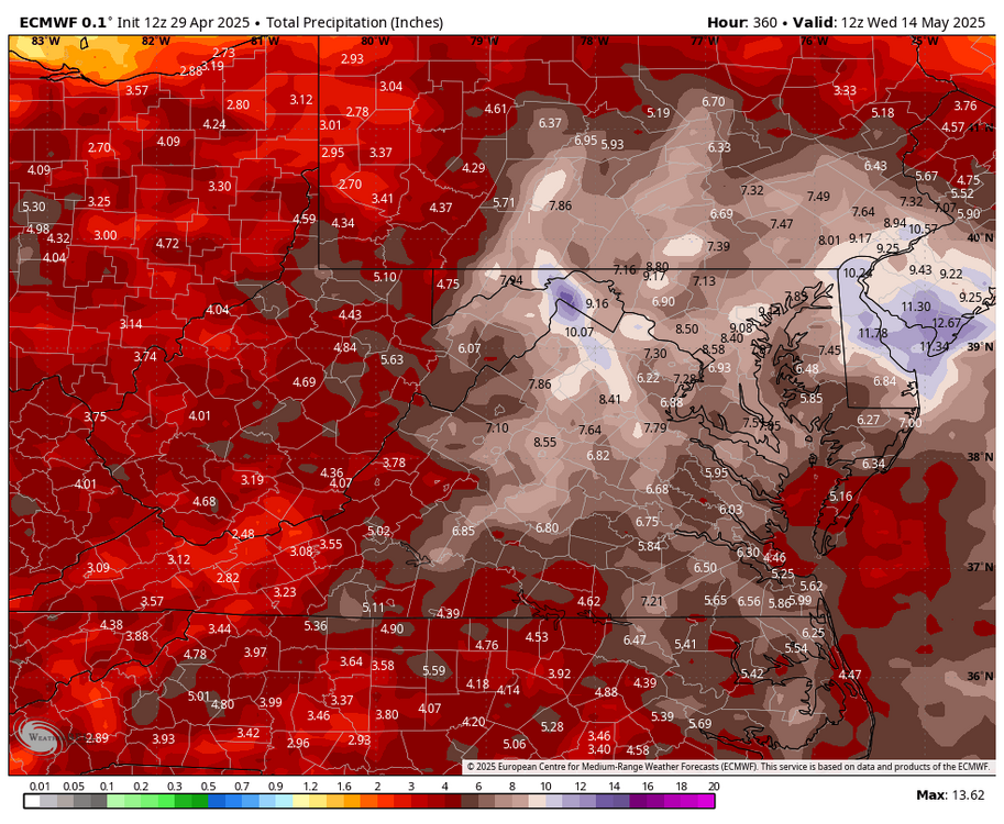
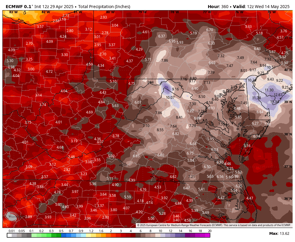
Man, the Euro wants to keep an ULL parked over the eastern US all next and just dump on us for days on end. Far from any type of model consensus, as solutions run the gamut, but has shown up in varying forms on other runs. Verbatim would lead to the 10-day totals shown below. Something to keep an eye on as we move towards the weekend. -
Euro mid range over amped bias kicking in again?
-
Just stepped out for a quick break and it is legitimately warm out. I haven't checked the current temps/dp yet, but I sense a touch of humidity (though not much).
-
Long range Euro but drought's over
-
lol at 84F at MVL. Might get a 50 degree diurnal.
-
Yep not terrible on the barrier islands actually. Long Beach made it up to 60. Winds are picking up though-JFK at 20mph this hour so right on the water might be nasty with blowing sand.
-
Southern NJ and PA flooded on the Euro
-
oh, it was the 06z GFS with that lewd west retro thing. But even this 12z idea strains cred for me by some. The 00z GFS is probably closer to what happens thu D10.
-
I feel that is unlikely to happen. It's bordering on absurd closing a NS/NF mid/ua low and then drilling almost to BUF. For one, that has never happened like that in the 35 years I've been privy to modeling technology - pretty much the whole way... In objective fairness, I suppose it is not IMpossible ... if the model's selling things that are, that would be a pretty bad deterministic tool, huh. But the unlikeliness being what it is ( based on history; based on 'wtf how could it' ), lends to an expose of error. I think the Euro is far in way more reasonable. I could see a weaker cut off getting caught in the ridge amber down there. That's not unusual, although it's perhaps at a slightly lower latitude than climo. It also dumps in a small portion of new dynamics, helping to regrograde. Personally...? I think there's some chance that it's all overblown.
-

2025 Spring/Summer Mountain Thread
WxKnurd replied to Maggie Valley Steve's topic in Southeastern States
Gorgeous pictures guys! -
This has a 10% chance of verification: