All Activity
- Past hour
-
-
Fusion is going to make a lot of enemies, even renewable energy companies. I think of plastic recycling, supposedly it was good for the environment. It's actually really bad, as it produces an immense amount of microplastics. Good luck trying to shut down the plastic recycling industry! Haha
-
There should be a nice sea breeze both tomorrow and Friday for the coast keeping temps down to comfortable levels (for me) after mid afternoon.
-
There is natural variation in climate and then there's human induced changes. Just like you can die of natural causes or of a drug overdose. One was a natural death, the other self inflicted. Right now humanity is a major drug addict lol
-
Maybe? I’m not sure, that’s before my time. In the 90s movie this cute scientist discovers cold fusion and Val cons her and steals the formula she keeps in her brah. The interesting thing is, the Russian oligarchs try to steal it first because fusion is really bad when you make billions off natural gas. That has to be a major deferent to making fusion a reality. Exon Mobil isn’t about to start paying for fusion research.
-

2025-2026 ENSO
Stormchaserchuck1 replied to 40/70 Benchmark's topic in Weather Forecasting and Discussion
I don't mean to sound grumpy or anything, I just don't think there's any science behind it. I remember the days when scientific reasons were given ahead of an analog composite, so that the analogs 2nd'd the point. I think Ray (40/70) still proceeds like that. -
Today was another delightful spring day. Readings rose into the 70s. The warm weather will continue through the week. It will turn somewhat cooler but remain mild during the weekend. A moderate rainfall is possible during the weekend. The ENSO Region 1+2 anomaly was +0.6°C and the Region 3.4 anomaly was -0.2°C for the week centered around April 16. For the past six weeks, the ENSO Region 1+2 anomaly has averaged +1.08°C and the ENSO Region 3.4 anomaly has averaged 0.00°C. Neutral ENSO conditions will likely continue through at least early summer. Early indications are that summer 2025 will be warmer than normal in the New York City and Philadelphia areas. The potential exists for a much warmer than normal summer (more than 1° above normal). The SOI was -7.79 today. The preliminary Arctic Oscillation (AO) was -0.743 today. Based on sensitivity analysis applied to the latest guidance, there is an implied 88% probability that New York City will have a warmer than normal April (1991-2020 normal). April will likely finish with a mean temperature near 54.8° (1.1° above normal).
-
100% agree. The planet is what about 4.5 billion years old, give or take a half billion. Just when exactly was the climate not changing? To think we're going to change anything by driving around in plug in cars and silencing cow farts is absurd. Experiments to dim sunlight? Yeah, that will end well.
-
-Don’t forget 1990-1. -I agree that 2014-5 is a 3rd year La Nada based on RONI even though the ONI is weak El Nino.
- Yesterday
-

2025-2026 ENSO
PhiEaglesfan712 replied to 40/70 Benchmark's topic in Weather Forecasting and Discussion
Second or later year of ENSO neutral (since 1949-50) - PHL 1960-61 (2nd year of ENSO neutral): 28.9F DJF; 49.1 in snow 1961-62 (3rd year of ENSO neutral): 30.5F DJF; 29.2 in snow 1962-63 (4th year of ENSO neutral): 28.3F DJF; 20.5 in snow 1967-68 (2nd year of ENSO neutral): 32.6F DJF; 15.9 in snow 1981-82 (2nd year of ENSO neutral): 31.2F DJF; 25.4 in snow 1993-94 (2nd year of ENSO neutral): 33.0F DJF; 23.1 in snow 2013-14 (2nd year of ENSO neutral): 33.0F DJF; 68 in snow 2014-15 (3rd year of ENSO neutral?): 32.6F DJF; 27 in snow All much colder than normal. Most of the years produced near normal snowfall, with 2 of them (1960-61 and 2013-14) producing blockbuster seasons. -

2025 Spring/Summer Mountain Thread
Maggie Valley Steve replied to Maggie Valley Steve's topic in Southeastern States
We had an hour+ of rumbles of thunder and gentle rain. What can be better! -
Advnaced stats are positive for Adley. He’s gotten some real bad luck relative to the quality of his contact and ABs. But as a whole the offense has been disappointing and dreadful against lefties.
-
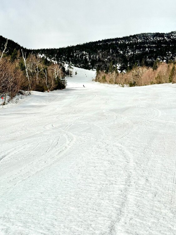
Only 4 more days before we shut ‘em down. This morning might’ve been the the best one left. 72” at the stake on a 54” average. It’s time though. I’m ready. Bring the warmth.
-
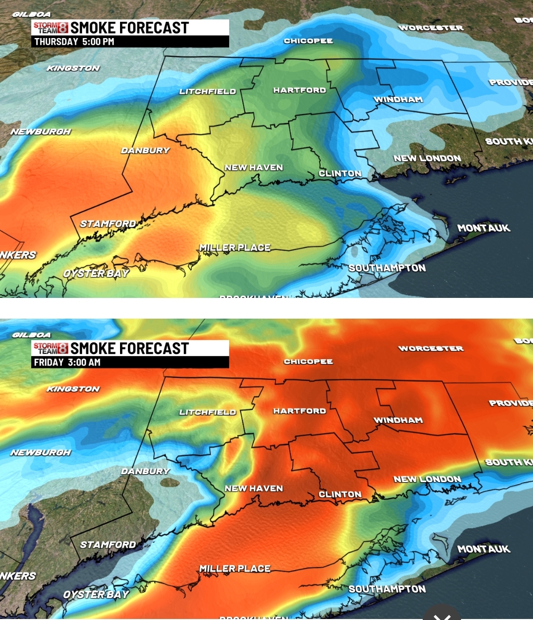
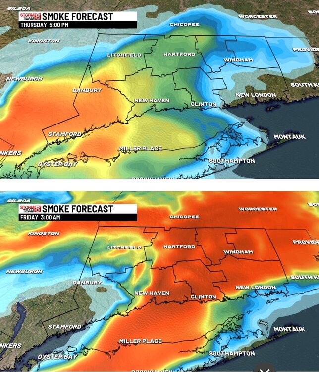
We are burning
-
-
Hrrr says we are on tap for a smokey day tomorrow due to the NJ wildfire.
-
A nice, pleasant, 60 degrees here now.
-
What a furnace in early Mayorch
-
Gotta feel the breeze somehow…
-
Records: Highs: EWR: 88 (1996) NYC: 86 (2007) LGA: 85 (2007) JFK: 87 (1973) Lows: EWR: 32 (1933) NYC: 29 (1872) LGA: 36 (1986) JFK: 34 (1986) Historical: Historical: 1885 - The city of Denver, CO, was in the midst of a storm which produced 23 inches of snow in 24 hours, and at Idaho Springs CO produced 32 inches of snow. (David Ludlum) 1910 - The temperature at the Civic Center in Los Angeles, CA, hit 100 degrees to establish an April record for the city. (The Weather Channel) 1948: A three block long section was devastated at the edge of Ionia, Iowa in Chickasaw County by an estimated F4 tornado. Six homes and a church were leveled, and nine other homes were severely damaged. Two deaths occurred in the collapse of the Huffman Implement Store. Overall, the tornado killed five people, injured 25, and caused $250,000 in damages. An F2 tornado touched down initially 5 miles northeast of Rochester. Barns, silos, windmills, and machinery were destroyed on four farms as this tornado tracked north. 1961: Severe weather struck the south suburbs of Chicago, IL. Joliet, IL reported an inch of hail with some hailstones the size of golf balls. Heavy rain from these storms also resulted in some flooding. A tornado struck the town of Peotone resulting in damage to nearly every building with damage also reported in Lorenzo and Wilton Center, IL. Estimated damage was $9 million with about 30,000 structures affected. 1983 - A mini-blizzard produced sixteen inches of snow at Laramie, WY, including a foot of snow in just eight hours during the night. (The Weather Channel) 1987 - Thunderstorms in the Atlantic Coast Region produced golf ball size hail and wind gusts to 67 mph at Anderson SC. The high winds destroyed two planes at the airport, and the large hail damaged fifty other planes, and severely damaged twenty-three greenhouses. (The National Weather Summary) (Storm Data) 1988 - An intense winter-like storm brought thunderstorms to southern California, and produced snow in some of the higher elevations. Nine girls at Tustin CA were injured when lightning struck the tree under which their softball team had taken shelter from the rain. (The National Weather Summary) (Storm Data) 1989 - Salina, KS, was the hot spot in the nation with a high of 105 degrees. The high of 105 degrees established an April record for the state of Kansas. A total of eighteen cities in the central U.S. reported record high temperatures for the date. (The National Weather Summary) (Storm Data) (The Weather Channel) 1990 - Thunderstorms produced severe weather in West Texas and western Oklahoma. Thunderstorms produced tennis ball size hail at Lake McKenzie TX and at Garden City TX, and produced wind gusts to 90 mph at Gage OK. Thunderstorms drenched southeast Minnesota with heavy rain, with 6.6 inches reported northwest of Browndale. High temperatures were mostly in the 80s across the central U.S. The morning low of 67 degrees at Fargo ND and afternoon high of 91 degrees were both records for the date. (Storm Data) (The National Weather Summary) 1999: On Friday, April 23, 1999, a horrific hailstorm moved southeast from Pennsylvania across Garrett County, Maryland and into the Eastern Panhandle of West Virginia. It had weakened some as it crossed Garrett County and the Allegany Front, but as it passed east of Keyser, West Virginia, hail began to increase in size once again. By the time it reached Capon Bridge in eastern Hampshire County, West Virginia, the size of the hail had grown from golf balls to baseballs. As it moved into Frederick County, VA, the hail storm continued to grow dropping golf ball size hail in a swath now reaching from the north of Winchester, south to Stephen City (about 10 miles). Hailstones grew to the size of Grapefruit (4 inches in diameter) east of Winchester. The storm continued east through Clarke County, southern Loudoun, and northern Fauquier doing considerable damage to Middleburg, then across Fairfax County hitting Centreville, Chantilly, Fairfax, Burke, Springfield, and Lorton with golf ball size to baseball size hail. It crossed the Potomac River and weakened slightly. It moved across northern Charles, clipped southern Prince Georges and then into Calvert County with 1 inch to 1.5-inch diameter hail and onto the Chesapeake Bay continuing southeast to the ocean. The damage left behind was incredible. In Northern Virginia alone, it amounted to over $50 million in losses to public and private properties. Some communities saw a third of the homes with siding and roof damage. Some required total replacement. Windows were broken, cars dented, and windshields smashed. Piles of shredded plant debris were left on the ground in the storm path. In about 6 hours of time, this one thunderstorm, moving at about 50 mph, did $75 million in damage. There have been other severe hail storms to hit this area before, but none to cause this much damage to property.
-

E PA/NJ/DE Spring 2025 Obs/Discussion
rcostell replied to PhiEaglesfan712's topic in Philadelphia Region
You know it about the greenheads! Blackflies are really annoying- but greenheads just plain hurt! Those marshes with the wind down can be tough, agreed. Great Bay was a great fishing bay- 10 pound weakfish were not unknown...good waterfowl hunting, too. The Baymens museum in Tuckerton is a great stop, if you've never seen it. -
Any nudity?
-
Absolute top shelf day today
-
Kind of a Steiner . It’ll shower sure.. but nothing drenching to put out fires.
-
The young stars continue to disappoint. I don't know what is wrong with Adley but something changed around the allstar break last year. I'll give Henderson a break for another few weeks.