All Activity
- Past hour
-
While it has been windier in recent years, this year is the new high average wind gust leader from January through April at nearly 35mph for the first time. https://mesonet.agron.iastate.edu/plotting/auto/?_wait=no&q=140&network=NJ_ASOS&station=EWR&syear=1900&sday=0101&eday=0429&varname=avg_wind_gust&w=none&thres=1&year=2025&_r=t&dpi=100&_fmt=png
-
Canadian is even worse.
-

2025-2026 ENSO
40/70 Benchmark replied to 40/70 Benchmark's topic in Weather Forecasting and Discussion
Yes., exactly. But I still don't see any difference between the warmer interlude circa 2025, during the multidecadal cold phase, and the late 1950s warmer period. They were both ENSO induced deviations from the predominate multidecadal cycle, which is why they were shorter in duration than warm phases that were congruent with the multidecadal state. -
Yeah, in a warmer world the troughs are becoming weaker. So the SSTs below haven’t been cooling as much. The cold pool couplet of the +PDO back in 2015 over the Central Pacific was much weaker than we saw back in 1997 due to the much weaker Aleutian Low. But the warm pool and 500 mb ridge near the West Coast was much stronger. So using the older calculation method doesn’t yield as strong of a +PDO. This raises the interesting question about future +PDOs in a warming world. Will there ever be an extended +PDO like we saw from the 1970s to 1990s again if we continue to see so much SST warmth from the CP back to the WP? Maybe this is why the +PDO cycle back in 2010s was so short. The other observation is that this recent -PDO has been more defined by the warm pool over the Western to Central Pacific than the cold pool near the West Coast. This is due to the much stronger Aleutian Ridge and weaker -PNA 500 mb trough than we saw from the 1950s to 1970s during that -PDO era. So the calculation method actually helped the -PDO values in recent years rival or match the older values from the 1950s to 1970s. Even though the trough near the West Coast was weaker than past -PDOs and SSTs warmer. I think we are just going to have to take a wait and see approach to the lengths of these PDO phases going forward. As a much warmer Western Pacific from the Maritime Continent to the south of the Aleutians loads the dice for more -PDOs than +PDOs. We will have to see if there is some possibility of the Eastern Pacific seeing an accelerated warming while the Western Pacific cools in the coming years. But if the Western Pacific continues to stay warm and increase the warmth, then +PDOs may be harder to come by. A clue as to if this can happen could be the unusual warming last few years in the Nino 1+2 region and rapid rise in global temperatures. But we recently saw how that shallow warm pool could connect to the warm pool over the WP. So the stronger trades cooled it off and slowed a return to El Niño. But historically as least since 1950, we haven’t seen such a fast return to El Niño following such a strong El Niño like we had in 23-24.
-

2025-2026 ENSO
40/70 Benchmark replied to 40/70 Benchmark's topic in Weather Forecasting and Discussion
Yes, it did shift to a Modoki configuration, but it was late. -

2025-2026 ENSO
40/70 Benchmark replied to 40/70 Benchmark's topic in Weather Forecasting and Discussion
I agree. My inference is that we are just beginning to shift and it should continue throughout the latter portion of this decade...but obviously recovery from the depth of this multidecadal nadir will take some time. -
Negative, I was mistaken. I was just looking over Aprils stats and see I had 4 days of highs in the 80s with the highest of 86 on 4/19.
-
Nothing new about it. The only thing that is relatively new is constant "in your face" media and social media. Research the 1963 pine barrens fires. Research many of the other seasons with massive fires. The recent fire down here just has everyone on edge, and social media won't drop it. When you have droughts (1961-1966, 1998-2002, as examples,) all it takes is one idiot with a discarded cigarette, one arsonist, or one lightning strike as a catalyst for major fires. Add in some wind, and voila. Social media sometimes makes things seem unprecedented.... Don't fall for the nonsense. This is nothing new. Unfortunately, the new warning systems often act as alerts for arsonists to go out and wreak havoc (as mentioned in multiple state agency documents.)
-
22 year old was killed in State College PA yesterday in the severe T-storms. Tragic. That bow echo looked pretty intense going through the area. Lots of downed tree reports. 30000+ without power in State College area as well.
-
Over 12 hours without power here in Monroeville. 215,679 customers without power on the Duquesne Light outage page.
-

2025-2026 ENSO
40/70 Benchmark replied to 40/70 Benchmark's topic in Weather Forecasting and Discussion
Tongue-in-cheek...I'm with you on that. -

2025-2026 ENSO
40/70 Benchmark replied to 40/70 Benchmark's topic in Weather Forecasting and Discussion
No, last season I was actually a bit too warm, but snowfall was pretty good. As much as I quibble with Chris, I have to credit him for the adjustments I made last season. Many of his posts on the changes we are seeing in the WPAC were very illuminating, and I was able to see why I have been busting cold and snowy the past couple of seasons in this regime. We often don't see eye to eye, but he definitely brings a lot to the table. I think he has the right idea generally speaking, but he is just a bit more aggressive with extrapolating larger scale changes forward than I am. -
Three minute downpour here.
-
I stretched and put down a trace
-
I attended that game in NY last June when the Orioles won 17-5. Yankee fans’ tears were delicious. Had no idea then that would be the peak for this group. Since that game, the Orioles are 53-66 (.445) and 11-21-5 in series play. In that same time, after a win the O’s are 19-34 with a .317 OBP and a 5.42 ERA.
-
No much here 0.02”
-
Wild ride in this morning through Allegheny County, roads closed, miles and miles of neighborhoods without power, no traffic lights / street lights. Debris everywhere. Some places looked like war torn hell-scapes.
- Today
-
its been moving north we flood
-
I thought some said we were done with frost and start planting Thursday Patchy frost before 7am. Otherwise, mostly sunny, with a high near 66. Calm wind becoming southwest 5 to 8 mph in the afternoon.
-

Central PA Spring 2025
Mount Joy Snowman replied to canderson's topic in Upstate New York/Pennsylvania
A muggy low of 67 here. No rain at all at my place but once I got a couple miles into my drive the roads were wet. Dew points should drop like a rock today. A beautiful couple days ahead before the rain arrives. -
So it looks like 0.10" from the "event", which IS pretty much spot on with the forecast from yesterday, as they said a tenth to a quarter inch. While it looked like the line was going to hold, it fizzled at I-81, but...we weren't really supposed to get the big storms here anyway. I had just hoped for a bit more rain for my newly emerging grass areas.
-
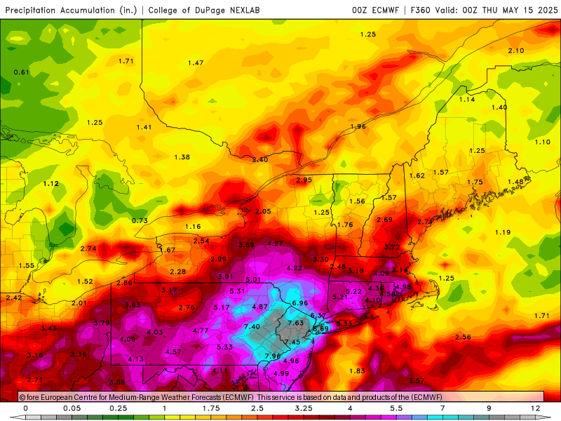
Euro, euro-Ai, and icon still onboard. GGEM jumped onboard at 0z. Gfs still says no.
-
Had a little bit of rain overnight sounded like more but only .04 I'll take it though
-
60s all night, but CAA is kicking in now. 58° and dropping. Maybe u40s by 8a?


