All Activity
- Past hour
-
Yes, officially the first April morning that hasn’t dropped below 73. If we weren’t getting a cold front today we could have obliterated the record warm low for April.
-
Someone is grilling BBQ in my neighborhood at 830am. The forecast calls for clouds all day, yet 86 as a high. Sent from my SM-G970U1 using Tapatalk
-
we knew Tuesday Night through Friday: A cold front moves through Tuesday night into early Wednesday morning. This will bring a slightly cooler airmass in for Wednesday, but still slightly above normal with highs in the 60s in most places. Similar pattern stays in place through the end of the week with zonal flow and 850mb temperature anomalies signaling slightly above normal temperatures. Ensemble guidance shows a signal for a more unsettled pattern Friday into the weekend with potential for periodic chances for precipitation.
-
You joke, but two of my neighbors did this and now the forest floor is just bare earth that's bone dry and invasive honeysuckle and oriental bittersweet are springing up all over by the hundreds. Idiots.
-
Yeah, moving the ASOS under the trees in the 1990s has kept the 90° day count closer to 20. My guess is that if the ASOS was out in the open like before 1995, NYC would have had well over 40 days reaching 90° back in 2010 instead of only 37. So it’s the only site away from the immediate shore which has had a decrease in 90° days. The sea breeze at Newark has been slowing the rate of increase there relative to sites like Freehold-Marlboro which have avoided the sea breeze. Over 40 days reaching 90°has become the norm away from the sea breeze in NJ during the 2020s. https://mesonet.agron.iastate.edu/plotting/auto/?_wait=no&q=74&network=NJCLIMATE&station=NJTEWR&season=all&dir=above&var=high&threshold=90&year=1961&_r=t&dpi=100&_fmt=png


-
Big
-

Winter 2024-2025 All Tri-State Snowfall Totals Maps
The 4 Seasons replied to The 4 Seasons's topic in New York City Metro
If anyone has any seasonal snowfall totals that have changed since March 10th let me know what your current season snowfall total is. Especially looking for anyone in Sussex, Orange, Putnam, Rockland, Westchester, Dutchess and Ulster counties. I'll be doing a final season snowfall map probably this week. -
67 in CPK at 8am with low-mid 50s along south shore of Brooklyn, Queens and Long Island. Temp at my location jumped from 57 to 64 as the wind shifted from SE to West.
-
yeah ...not impressed with this at all. i was afraid of this. we'll see how it plays out. sometimes these morning contamination looks erode back as the sun works, but seeing the guidance with waves of 700, 400, 300 mb > 60% doesn't looks like a scenario that exactly over achieves relative to what it could be. but we've suffered bottom dweller saturday's back to back recently so this is panacea by comparison. no complaints.
-
Got maybe 1" out of the 4-8" forecast. OK onto spring for real now
-

Southeast Regional Climate Center website down
eyewall replied to marsman's topic in Southeastern States
It only gets worse from here. -
I do think they’ll be more clouds up your way.
-
It’s mostly sunny here just high clouds expecting 82-87 here. Will be on the baseball fields for 10 hours today bring on the heat! This evening looks like mid summer with temps in the 70s with moderate humility and some thunder showers around.
- Today
-
Got hammered between 6:30-6:50 (EDT) this morning. Caught 0.53" in that timeframe, with pea sized hail and some great lightning. The hardest I've seen it rain in a long time. Nice way to wake up on a Saturday morning.
-
And yeah, I pulled out cloud clowns. lol But upstream looks fairly putrid early. I suppose we don’t need many breaks with a warm airmass to get enough mixing for 75-85, but I’d rather have yesterday than this on the weekend.
-
-
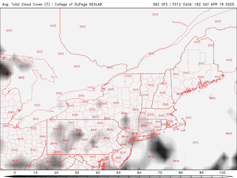
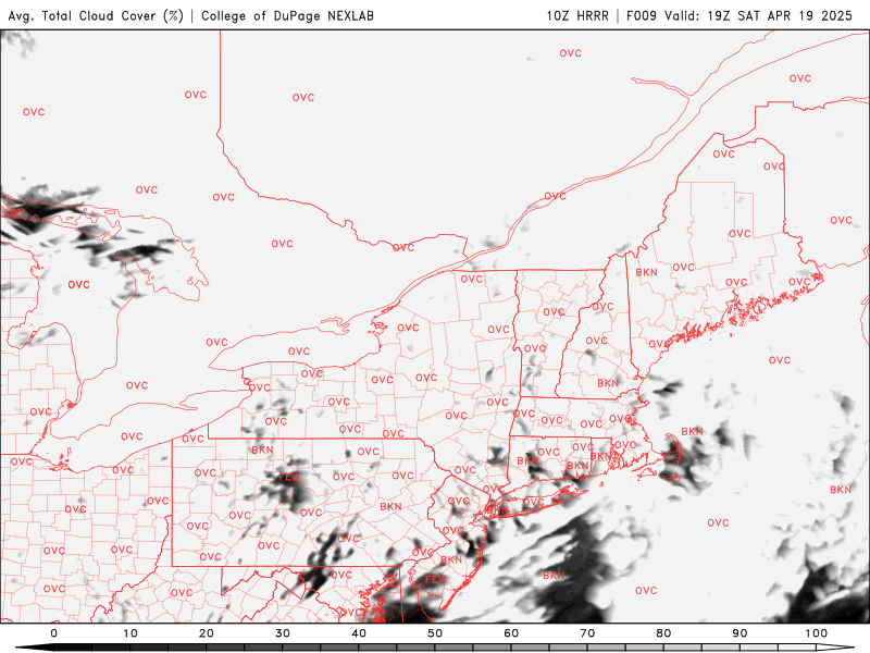
HRRR always overdoes clouds.. it’s also way overdone on those storms this evening. Nothing else has anything like that .
-
Records: Highs: EWR: 92 (1976) NYC: 92 (1976) LGA: 85 (2002) JFK: 84 (1985) Lows: EWR: 33 (2020) NYC: 21 (1875) LGA: 35 (1983) JFK: 34 (2001) Historical: 1775 - The first engagement of the Revolutionary War took place under clear crisp weather at Lexington-Concord. (Sandra and TI Richard Sanders - 1987) 1927: A deadly tornado outbreak occurred across the central part of Illinois, killing 21 people. The first tornado touched down near Hardin, traveling northeast through Carrollton, then skimmed the south side of Springfield. At Carrollton, a teacher was killed as she held the door of the school shut, saving the lives of her students. The second tornado, peaking at estimated F4 intensity, touched down on the southeast side of Springfield, then moved to affect the towns of Riverton, Buffalo Hart, Chestnut, and Cornland. In Buffalo Hart, only three houses were left standing, while the northern half of Cornland was leveled. The tornado track was 65 miles, ending in Ford County. 1941 - The temperature at Sodus, NY, soared to 95 degrees. The next day Albany, NY, reported a record for April of 93 degrees. (The Weather Channel) 1973 - Glenrock, WY, received 41 inches of snow in just 24 hours, and a storm total of 58 inches, to establish two state records. (18th-20th) (David Ludlum) (The Weather Channel) 1976 - The northeastern U.S. was in the midst of an early season heat wave, and the Boston Marathon took place in 90 degree heat. At Providence RI the mercury hit 98 degrees. (David Ludlum) 1986: A major storm system produced ten tornadoes in Texas. One of these tornadoes virtually annihilated the town of Sweetwater. The tornado struck at the unlikely time of 7:17 am. One person was killed, and 100 were injured. 1987 - Forty cities in the central U.S. reported new record high temperatures for the date as readings soared into the 80s and lower 90s for Easter Sunday. Fort Smith AR reported a record high of 95 degrees. (The National Weather Summary) 1988 - Severe thunderstorms over the southeastern U.S. early in the day spawned a strong (F-3) tornado which destroyed seventeen homes and severely damaged thirty houses near Madison FL killing four persons and injuring eighteen others. (Storm Data) (The National Weather Summary) 1989 - A dozen cities in the southwestern U.S. reported new record high temperatures for the date. The afternoon high of 98 degrees at Hanksville UT equalled their record for April. Tucson AZ reported their earliest 100 degree reading of record. (The National Weather Summary) 1990 - Five cities in the northeastern U.S. reported record low temperatures for the date as readings dipped into the 20s and upper teens. Elkins WV reported a record low of 20 degrees. Thunderstorms over the Southern Plains produced golf ball size hail at San Angelo TX, and up to four inches of rain in southwestern Oklahoma. (The National Weather Summary) (Storm Data) 1996 - One of the most memorable tornado outbreaks in Illinois history occurred on April 19, 1996. During the day, 33 tornadoes were reported as supercells erupted and moved across the state during the afternoon and evening hours. Wind estimates in excess of 170 mph were associated with some of the stronger tornadoes, one of which ripped through nearby Ogden, IL. (University of Illinois WW2010) 2006: An intense spring snowstorm swept across the Dakotas, dumping up to 5 feet of snow. The heaviest snow fell in the Black Hills, with 59.4 inches at Lead, SD. Bowman, ND reported 18 inches. The storm closed highways including I-94 in North Dakota, cutting power to thousands and was responsible for at least four deaths. Further west, 1 to 3 feet of snow and 50 to 60 mph winds caused drifts up to 10 feet, widespread power outages, and livestock losses.
-
Hope so. Tough way to run 80s in mid April. I’m primed and ready to blow a gasket midday over failed heat.
-
Some of this cirrus probably breaks up a bit this aftn.
-
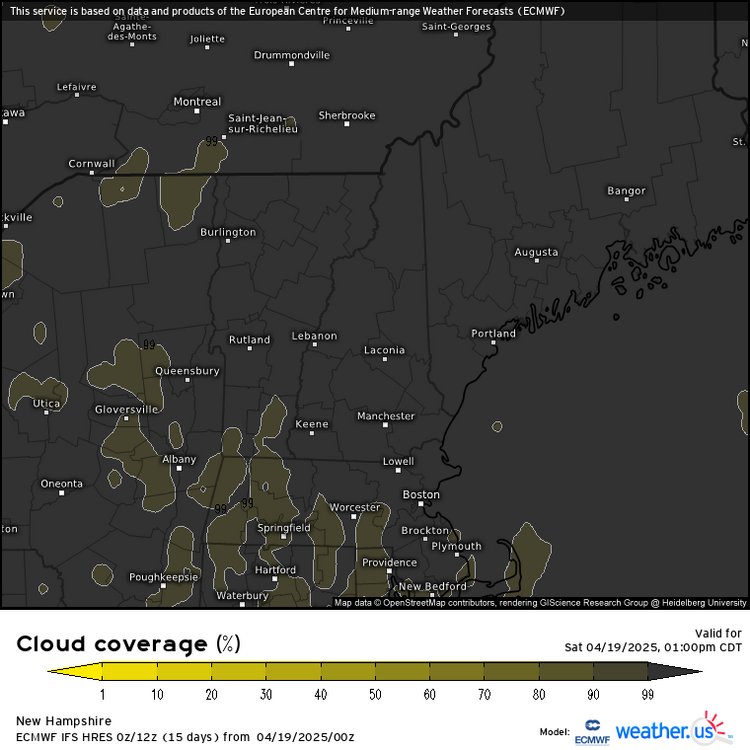
Gets close to the warm season and already clouds invade NNE.
-
67 / 52 and cloudy. Very warm and windy low - mid 80s pending on breaks in the clouds and sun. Front comes through later tonight. Cooler but pleasant Easter Sunday. Monday looks to be caught in the grey with temps stuck near 60. Tuesday back to the upper 70s / low 80s and sunshine. Rindge into the east and overall above normal 4/18 - 4/26. Remaining dry as well 02.5 or less rainfall forecast in the next 7 days with Thu.Fri the next shot at light rain.
-
Also, the 7 am temperature of 74F was the highest observation for that time at PIT.
-
Vis looks like shit. Min 48.5° and we haven’t risen much from that.
-


.thumb.png.e1f898d009b2415a204433df288e6f2a.png)


