All Activity
- Past hour
-
Walker, six scoreless innings today in a Phils win, stud. Upper brass already compiling a contract extension...
-
Mostly NW of us. But, better than nothing, just wish it would not be cloudy every day.
-

2024-2025 La Nina
Stormchaserchuck1 replied to George001's topic in Weather Forecasting and Discussion
That means if you subtract 0.2 to account for global warming trend (which is about what it is: 0.2 to 0.3), this event did officially hit Weak Nina. -

2025 Atlantic Hurricane Season
Stormchaserchuck1 replied to BarryStantonGBP's topic in Tropical Headquarters
What's your prediction, Barry? -
78/70
- 352 replies
-
- severe
- thunderstorms
-
(and 2 more)
Tagged with:
-

E PA/NJ/DE Spring 2025 Obs/Discussion
RedSky replied to PhiEaglesfan712's topic in Philadelphia Region
Feels like mid May Nice -
81/64 at DCA at 5pm
- 352 replies
-
- severe
- thunderstorms
-
(and 2 more)
Tagged with:
-

2025 Atlantic Hurricane Season
BarryStantonGBP replied to BarryStantonGBP's topic in Tropical Headquarters
underestimating -
2024-2025 La Nina
PhiEaglesfan712 replied to George001's topic in Weather Forecasting and Discussion
JFM 2025 ONI (NOAA): -0.4 JFM 2025 RONI: -0.90 March 2025 PDO: -1.12 -
Tomorrow will remain warm, but showers and perhaps a thundershower are possible as a cold front moves through the region. It will turn cooler on Saturday and then milder again on Sunday. Showers are possible during the weekend.The first half of next week could feature below normal temperatures. Two big stories will likely dominate the U.S. weather this week. First, a major to historic rainfall event is likely to affect parts of the Tennessee Valley tomorrow through Sunday. Excessive rainfall is likely in parts of Arkansas, Kentucky, Missouri, and Tennessee. Second, unseasonable heat is likely in parts of the Southeast. Tampa could experience its earlest four-day heatwave on record during April 2-5. The existing record is April 26-29, 1991. The ENSO Region 1+2 anomaly was +0.9°C and the Region 3.4 anomaly was -0.1°C for the week centered around March 19. For the past six weeks, the ENSO Region 1+2 anomaly has averaged +1.00°C and the ENSO Region 3.4 anomaly has averaged -0.18°C. Neutral ENSO conditions will likely continue into at least late spring. Early indications are that summer 2025 will be warmer than normal in the New York City and Philadelphia areas. The potential exists for a much warmer than normal summer (more than 1° above normal). The SOI was +26.82 today. The preliminary Arctic Oscillation (AO) was +0.527 today.
-

2024-2025 La Nina
Stormchaserchuck1 replied to George001's topic in Weather Forecasting and Discussion
We did have +NOI, which is a little High pressure off the West coast. That's what I look for, for ENSO effects. And the year before in Strong El Nino, although we had mostly -PNA, it was -NOI. The North Pacific High region has greatest ENSO correlation effects, not the PNA (very misunderstood).. although I guess you can say in west-based events it's more PNA-correlated. -

2025 Atlantic Hurricane Season
Stormchaserchuck1 replied to BarryStantonGBP's topic in Tropical Headquarters
CSU's numbers were way high last year.. I think they were going with a near record season. I think Gawx has researched it, and come to the conclusion that they have an over-active bias on seasonal forecasts, based on several years of putting out forecasts. I don't think 17NS, 9 Hurricanes is that far off the progression average though.. 8 of the last 9 years have had 7+ Hurricanes. 4 of the last 5 years have had 18+ Named Storms. We had a quiet period mid-season last year that may signal a turn to less active conditions though. -
0.11” rain this morning east Columbia. Same for BWI.
-
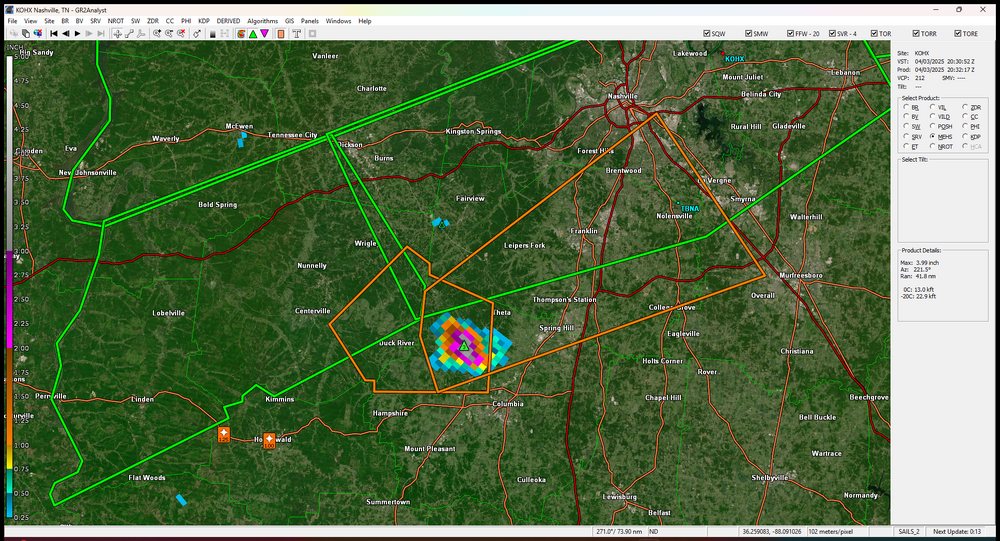
large severe warned supercell by Franklin, TN (hail) edit: tornado warning just issued
-
Chester County PA - Analytical Battle of Actual vs. Altered Climate Data
chubbs replied to ChescoWx's topic in Climate Change
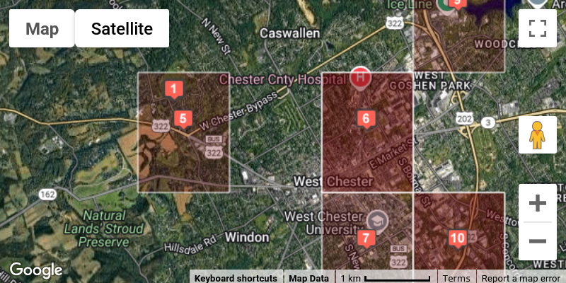
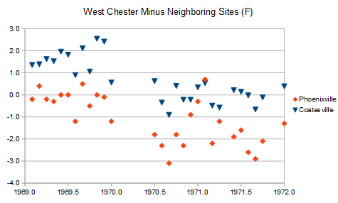
Here is a map of West Chester station locations from the NOAA Observing Data Metadata Laboratory (link below). In 1970 the station moved from the middle of West Chester (site 6) to the Daily Local News office on the western outskirts side of town (site 5). In 1998 the station moved to the observer's house (site 1). Easy to see the effect of the 1970 move by comparing West Chester to other County stations. Below is a plot of monthly data before and after the move for Wes Chester, Coatesville and Phoenixville. The West Chester station closed at the old location at the end of the year in 1969 and re-opened at the new location in May 1970. I removed the annual temperature cycle by subtracting Coatesville and Phoenixville from West Chester. A lower value means West Chester cooled relative to the other stations. The chart shows roughly 2F cooling at the West Chester station that coincided exactly with the move. The raw data is conclusive on the move effects. https://www.ncei.noaa.gov/access/homr/#ncdcstnid=20016596&tab=LOCATIONS -
That sounds more like a "we'll re-evaluate in a few hours" MCD than a no chance of a watch
- 352 replies
-
- severe
- thunderstorms
-
(and 2 more)
Tagged with:
- Today
-
I have two friends in the UK. They are constantly amazed at our extremes. A cold summer here would still be oppressively hot there, and a warm winter here would be frigid there. An average summer in Detroit is 7° warmer than London, and an average winter in Detroit is nearly 16° colder than London.
-
It's only a 20% MCD *but* I love when I make a statement that SPC and WxUSAF agree with! I must be learning! Mesoscale Discussion 0381 NWS Storm Prediction Center Norman OK 0331 PM CDT Thu Apr 03 2025 Areas affected...Portions of West Virginia and northern Virginia Concerning...Severe potential...Watch unlikely Valid 032031Z - 032300Z Probability of Watch Issuance...20 percent SUMMARY...Storms moving into West Virginia may pose a threat of severe weather this afternoon and evening. Convective trends will continue to be monitored, although a watch appears unlikely at this time. DISCUSSION...Despite midlevel height rises across the area, low-level warm-air advection continues to support thunderstorm development across eastern Kentucky. The storms are expected to continue moving eastward across West Virginia, though high clouds and poorer boundary-layer moisture (per 18Z RNK sounding) have limited destabilization. With low-level flow (and attendant warm advection) forecast to increase into the evening, there is a threat for the convection to persist. Given the sufficient low-level and deep-layer shear across the area, these storms will have the potential to produce damaging winds, hail, and a tornado. Trends will be monitored through the evening, but a watch appears to be unlikely at this time. ..Jirak/Guyer.. 04/03/2025
- 352 replies
-
- 1
-

-
- severe
- thunderstorms
-
(and 2 more)
Tagged with:
-
MCD just came out for WV into VA to just southwest of DC
- 352 replies
-
- severe
- thunderstorms
-
(and 2 more)
Tagged with:
-
-
It has some snow for areas mostly N of 80 on 4/8 in the map below; it also has some more snow on 4/12 for areas N of 84 and then even more on 4/18 for the Catskills/Berkshires and north. Assuming you want the first one that gives you a bit of snow.
-
My PWS is showing a 68.9 dewpoint YUCK!
- 352 replies
-
- severe
- thunderstorms
-
(and 2 more)
Tagged with:
-
NROT IS UP TO 2 now that cell headed towards Thompsons Station
-
That sure look like a tornado to me..lol
-
Just got off of night shifts this morning and I can say this past 5-7 nights were complete hell in the forecasting world. Never in my wildest dreams did I think I would be issuing 2 High Risks and 4 Moderate Risks in a 4 days span without a single tropical cyclone in the mix. My ERD’s (Excessive Rainfall Discussions) were easily 2000+ words in length each night. Just absolutely insane. I’m done till next Tuesday, but I’ll remember that set forever.


