All Activity
- Past hour
-

E PA/NJ/DE Spring 2025 Obs/Discussion
Hurricane Agnes replied to PhiEaglesfan712's topic in Philadelphia Region
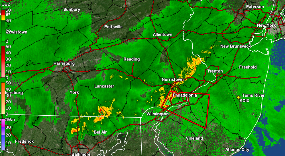
And another sound and light show incoming - this time early morning. STS up for south of me - Currently getting rain (0.07" in bucket at post time) and 67 with juicy dp of 66. -

E PA/NJ/DE Spring 2025 Obs/Discussion
Birds~69 replied to PhiEaglesfan712's topic in Philadelphia Region
All out thunderstorm, heavy rain/ downpour. -

E PA/NJ/DE Spring 2025 Obs/Discussion
Birds~69 replied to PhiEaglesfan712's topic in Philadelphia Region
Lightning, thunder and rain picking up... - Today
-
E PA/NJ/DE Spring 2025 Obs/Discussion
Joshb32689 replied to PhiEaglesfan712's topic in Philadelphia Region
Good morning 2 hours early to all. Holy lightning in the Coatesville area -
Holy elevated convection batman.
- 363 replies
-
- severe
- thunderstorms
-
(and 2 more)
Tagged with:
-
2024-'25 The winter of the mid-south.
-
Ok then - https://www.spc.noaa.gov/products/md/md0390.html Mesoscale Discussion 0390 NWS Storm Prediction Center Norman OK 0252 AM CDT Fri Apr 04 2025 Areas affected...ern WV Pnhdl...nrn VA...MD...DC...srn PA...DE...srn NJ Concerning...Severe potential...Watch unlikely Valid 040752Z - 040845Z Probability of Watch Issuance...20 percent SUMMARY...Strong, potentially damaging wind gusts, may accompany weak thunderstorm activity likely to spread east of the Blue Ridge and across the Greater Washington D.C./Baltimore metropolitan areas through 6-7 AM EDT. It is not clear that a severe weather watch is needed, but trends are being monitored. DISCUSSION...A narrow line of thunderstorms has shown some intensification, near and south of a wave or weak MCV now east of Elkins WV. This activity has been propagating rapidly eastward, along and just south of a slow moving or stalling cold front, around 50 kt, which is about the strength of the mean westerly deep-layer ambient mean flow across the Allegheny Mountains into northern Mid Atlantic. Due to generally weak deep-layer lapse rates, CAPE along this corridor is quite weak west of the mountains, but improves somewhat (CAPE to 500 J/kg) in better low-level moisture across northern Virginia through southern New Jersey. While some further intensification to the east of the Blue Ridge is possible as activity rapidly advances eastward through 11-12Z, thunderstorm intensities are likely to remain rather modest, based on forecast soundings. However, unsaturated profiles in lower/mid-levels, may contribute to evaporative cooling and downward momentum transport of rear-inflow, which may undergo some further convective augmentation. ..Kerr/Mosier.. 04/04/2025 ...Please see www.spc.noaa.gov for graphic product... ATTN...WFO...PHI...AKQ...CTP...LWX... LAT...LON 39897751 39677548 38737539 38497760 38557915 39397855 39897751 MOST PROBABLE PEAK WIND GUST...55-70 MPH
- 363 replies
-
- severe
- thunderstorms
-
(and 2 more)
Tagged with:
-
...except hard work.
-
Deep, deep thunder woke me up at 3:05. Pretty nice light show too with nice rain rate. Love a good thunderstorm that has no bite.
-
.thumb.jpg.6a4895b2a43f87359e4e7d04a6fa0d14.jpg)
Central PA Spring 2025
Yardstickgozinya replied to canderson's topic in Upstate New York/Pennsylvania
We have some convection in the area. I believe the nws did say the best instability would be overnight. -
-
coldest and snowiest winter ever.
-
temps going up up up!!! hot hot HOT! LFG!!!
-
Can't wait for the transition!
-
hopefully some towns are leveled prior this date; early svr
-
672hr CFS snow depth in May.
-

2025-2026 ENSO
Stormchaserchuck1 replied to 40/70 Benchmark's topic in Weather Forecasting and Discussion
Stratosphere Polar Vortex was strong, then it got ripped apart in March. https://x.com/NOAAClimate/status/1907805453859295460 Since 2000, these are the analogs where we had a strong 10mb PV Nov-Feb, getting torn up in March. Look at how in the following May, it shows this battle over the Arctic at 500mb.. it takes time for Stratosphere to make it to the surface.. in this case 2 months. There is even a +100dm anomaly over the Hudson Bay which is anomaly for 8 years in a short wavelength month like May. Following June-Sept: Again, see how the ridging gets split in middle by Arctic trough. Dominant 10mb vortex recenters with High pressure actually getting moved to the edges, down to the surface. ^It has even + and - years (4-4), so there's no global warming general thing in play. The warm March seems to be a warm signal for the Summer. -
2025-2026 ENSO
so_whats_happening replied to 40/70 Benchmark's topic in Weather Forecasting and Discussion
Highly localized area unfortunately. As of last month we are down about 3-3.5" on the year at BWI and if I include all of last year and so far this year we are sitting at about 10-11" below average which we have not seen in a very long time. I believe these numbers are even worse across SE PA, I know my area even after receiving about 1.5" of rain the other day 31st into the 1st we still have water restrictions across the area that were hoisted in November. Not very often we see something go into affect when it typically should start to be our wettest portion of the year. With this rain going on over the Ohio/Mississippi river valley region we should see some type of moisture inflow into this region but every model run closer to present we tend to get drier and drier. I think between now and Monday we should manage .5" to 1" of rain but I worry as getting to near normal is a step in the right direction but we are quickly approaching the time of year where we do not tend to see large synoptic style rain events. Stalled fronts and thunderstorms is the name of the game from about mid may onward and we all know this is hit or miss. All I can say is that it has not been terribly dry which is good but consistently not hitting the average mark for several months is a bit concerning especially going into summer. I feel the only way to get us close to average is through tropical systems, maybe this is our year. -
Greenfield Chris
-
Based on the 00Z suite, late night convection is pretty certain for areas along and north of I-70. Whether any of it makes it south towards the lower parts of Howard and Montgomery is less clear.
- 363 replies
-
- 2
-

-
- severe
- thunderstorms
-
(and 2 more)
Tagged with:
-
Agreed. 57/55 here now.
-

2025 Spring/Summer Mountain Thread
Tyler Penland replied to Maggie Valley Steve's topic in Southeastern States
NASCAR is coming to Bristol that weekend. You can pretty much bet on either the spring Martinsville or the spring Bristol race being absolutely freezing. Martinsville was straight up hot this year so..... -
Mountain West Discussion
mayjawintastawm replied to mayjawintastawm's topic in Central/Western States
Seems like Elbert County causes practically anything that goes through there to rotate. Must be a great big hidden fan or something.


.thumb.png.e1f898d009b2415a204433df288e6f2a.png)


