All Activity
- Past hour
-
My point was about the duration of the PDO cycling. I have posted numerous papers further back on how the length of the phases was different during different climate epochs. The period around 2015 was one off the most extreme +PDO and super El Niño couplets that we have ever experienced. I posted papers on this further back on how there was a model used which forecasted this shift. But the amplitude of the shift in the model was much weaker than what verified. So the period from around 2015 to the late 2010s was indeed a +PDO phase. But we cycled back to more -PDO into the 2020s. There was more research that the ENSO cycle has become more extreme using corals going back hundreds of years as the climate has warmed. This has been confirmed by how extreme the swing was between the super El Niño and +PDO was in 2015 and the -PDO and multiyear La Niña -PDO in the early 2020s.
-

Spring 2025 Medium/Long Range Discussion
Spartman replied to Chicago Storm's topic in Lakes/Ohio Valley
ILN wants to talk about a blocking pattern developing this weekend into next week .LONG TERM /WEDNESDAY NIGHT THROUGH MONDAY/... A robust short wave moving out of the Ozarks on Thursday will deamplify as it lifts up the Ohio Valley on Thursday night. At the surface, a warm front will lift across the region Wednesday night and there could be some showers and thunderstorms associated with that. Potential for showers and thunderstorms in the warm sector will increase with the combination of diurnal heating and the approach of upper support. Activity will wane somewhat as the short wave lifts away from the area later Thursday night. The short wave will take a surface low west and north of the region, but a trailing cold front will slide into the forecast area Thursday night. The front will not make it all of the way through the area until Friday and possibly Friday night when a stronger push comes from a northern stream trough digging into the region. Showers and some thunderstorms will continue until this trough passes east of the area. With the passage of this trough, the mid levels transition into a high amplitude, blocky pattern. A closed low will develop out of the base of the trough that moves through, but there is some potential that this low then retrogrades back into the region early next week. With quite a wide range of solutions on where a closed low will occur, have stayed pretty close to the NBM for now keeping the region dry. Temperatures will remain above normal through Friday and then drop below normal over the weekend. If the closed low stays east of the area, then temperatures will rebound early next week. 06z GFS: 00z Euro: -
I had thought the PDO cycle was going to change this year, but that does not appear to be the case. I think we remain in a -PDO cycle for at least another year. That said, I don’t think it’s going to be severely negative like we’ve seen over the last 5 years. Also becoming more convinced by the day that we see a cold-neutral/borderline weak La Niña ENSO (based on subsurface, surface, -PMM, trade winds, SOI trends)
-

Central PA Spring 2025
Mount Joy Snowman replied to canderson's topic in Upstate New York/Pennsylvania
Haha great, still learning how to properly inhale but we’ll get there. In all seriousness, my wife did a great job putting together a cops and pops (lollipop) theme for the two of them. Some sort of deal where our little girl was the robber and stole all the lollipops and our son was the cop trying to catch her. You know, the kind of thing wives thrive at and love to do. She really hit it out of the park though by contacting the West Hempfield Police and getting them to stop by the party. As you can imagine, the kids loved it haha. They all got to sit in the car and flick the lights and hear the sirens and whatnot. It was a big hit. Got to hand it to my lady, she nailed it. -
This would be a big surprise to most people. Point and clicks have dry beautiful weather through the weekend and into next week.
-
GWDLT 41F for my low. Could be a +40 day but I think it won’t get that warm.
-
Did you see the “new” circa 1990 map that James Neihaus made of Stowe?

-
0z euro suite continues that. Almost a drought buster next week. GGEM and GFS both show the blocky pattern producing some slow moving systems, but different than euro suite.
-
US National Weather Service State College PA Favorites · rSodenpstomc1t4h05l8313mt94l9h17a41tc18103lmma842c503tafmfgm · Check out the remarkable green up over the last month!
-
My best wishes to the female fox who announced very loudly that she is in heat outside our window at 330am
-
Low of 54.. ahhhh
-
Hazardous Weather Outlook National Weather Service State College PA 402 AM EDT Tue Apr 29 2025 PAZ004>006-010>012-017-018-024-037-041-300815- Warren-McKean-Potter-Elk-Cameron-Northern Clinton-Clearfield- Northern Centre-Cambria-Tioga-Northern Lycoming- 402 AM EDT Tue Apr 29 2025 This Hazardous Weather Outlook is for central Pennsylvania. .DAY ONE...Today and tonight. Severe thunderstorms with damaging winds 60 mph or greater and large hail exceeding 1 inch in diameter are probable this afternoon and evening. A few tornadoes are also possible. .DAYS TWO THROUGH SEVEN...Wednesday through Monday. The probability for widespread hazardous weather is low. .SPOTTER INFORMATION STATEMENT... Spotters are encouraged to report significant hazardous weather. $$ Hazardous Weather Outlook National Weather Service State College PA 402 AM EDT Tue Apr 29 2025 PAZ019-025>028-033>036-042-045-046-049>053-056-300815- Southern Centre-Blair-Huntingdon-Mifflin-Juniata-Somerset-Bedford- Fulton-Franklin-Sullivan-Southern Clinton-Southern Lycoming-Union- Snyder-Montour-Northumberland-Columbia-Perry- 402 AM EDT Tue Apr 29 2025 This Hazardous Weather Outlook is for central Pennsylvania. .DAY ONE...Today and tonight. Severe thunderstorms with damaging winds 60 mph or greater and large hail exceeding 1 inch in diameter are possible this afternoon and evening. .DAYS TWO THROUGH SEVEN...Wednesday through Monday. The probability for widespread hazardous weather is low. .SPOTTER INFORMATION STATEMENT... Spotters are encouraged to report significant hazardous weather. $$ Hazardous Weather Outlook National Weather Service State College PA 402 AM EDT Tue Apr 29 2025 PAZ057>059-063>066-300815- Dauphin-Schuylkill-Lebanon-Cumberland-Adams-York-Lancaster- 402 AM EDT Tue Apr 29 2025 This Hazardous Weather Outlook is for central Pennsylvania. .DAY ONE...Today and tonight. Strong to severe thunderstorms with gusty winds are possible this evening. .DAYS TWO THROUGH SEVEN...Wednesday through Monday. The probability for widespread hazardous weather is low. .SPOTTER INFORMATION STATEMENT... Spotters are encouraged to report significant hazardous weather. $$
- Today
-
74 at 4:30, warm overnight really pushed out leaves
-
Hit 77.0 yesterday. 10 out of 10 day.
-

2025 Atlantic Hurricane Season
BarryStantonGBP replied to BarryStantonGBP's topic in Tropical Headquarters
“From today's trip to the weather twitters. Deep tropic suppression because of warm sub-tropics would seem, to me, to decrease risk of a major landfall in the Caribbean and Central/North America.” LMAO no whoever said this keep getting your hopes up -
2025 Atlantic Hurricane Season
BarryStantonGBP replied to BarryStantonGBP's topic in Tropical Headquarters
Lmao not only the east Atlantic matters. Stop jumping to conclusions it will be above average at least -
2025 Atlantic Hurricane Season
BarryStantonGBP replied to BarryStantonGBP's topic in Tropical Headquarters
It will warm up soon btw “it will be below average/average!” -
FWIW, the ticks are terrible this year, absolutely terrible. We have an expert here that might be able to give us more details, maybe @JustinRP37 has some good data for us.
-
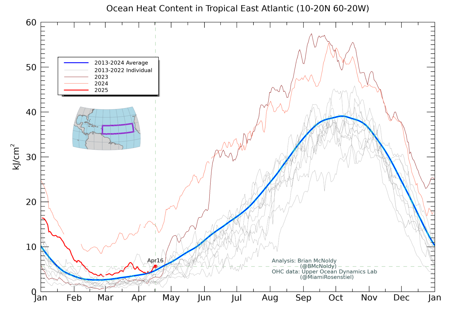
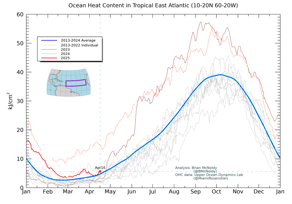
Thanks. The same website has OHC for the same region although it updates more slowly. I’ll be following this very closely also. This is the corresponding OHC for the same area as of April 16 as opposed to April 27. It shows that the OHC has also fallen a lot since one year ago, when it was way up at the 2013-24 average for late June! It was on 4/16/25 down to near the 2013-24 average for 4/16 although it actually was a bit warmer than 2023, which was within just days of rising rapidly and reaching then new daily record highs that would go all of the way into June of 2024: https://bmcnoldy.earth.miami.edu/tropics/ohc/ohc_east.png
-
Classic solid EML/deep summer setup tonight. A heat burst is occurring in S IA currently, with anvil showers across N MO/S IA. Oskaloosa, IA went from 76/64 to 81/43, with winds gusting to 69MPH.
-

2025 Atlantic Hurricane Season
LongBeachSurfFreak replied to BarryStantonGBP's topic in Tropical Headquarters
Again, that is only representative of the surface and not the OHC which is what really matters. We have seen a very windy NH winter which had the effect of turning over the surface. It’s not like the year over year temp dropped because the overhead temps were much colder then normal. Increased winds are well predicted by climate change models and are reason for counterintuitive storm number forecasts. -
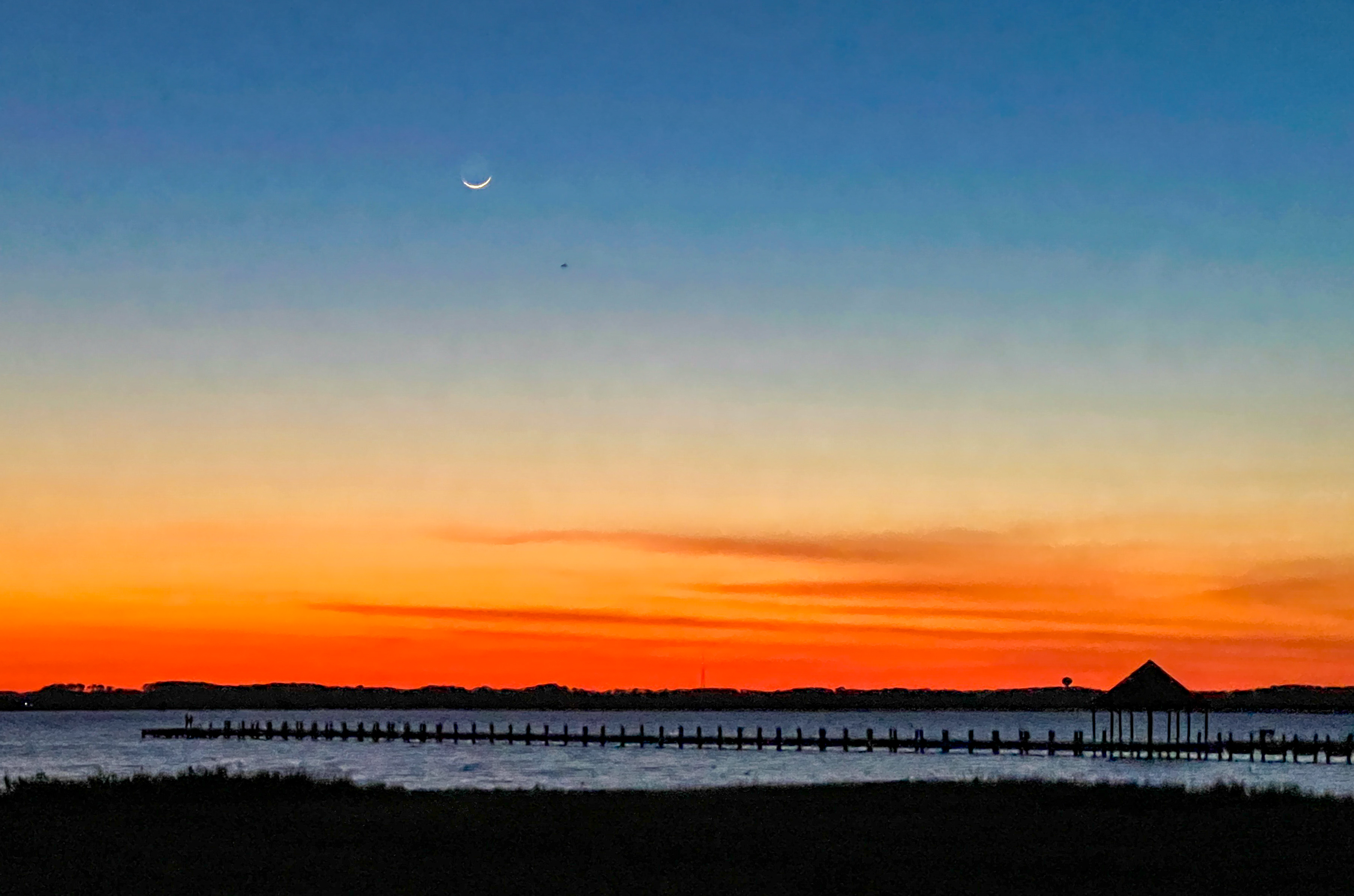
Very nice picture ! Was looking at that tiny sliver of the moon crossing Afton Mt west bound heading home from work tonight....
-
I'm calling it a night before waiting for the 00Z suite, but it's worth noting today that the Euro and AI-Euro both have the weekend trough cutting off and hanging around for a while and giving us a much-needed multi-day rain event. It seems to have some ensemble support. The GFS/GEFS, prior to the overnight runs, are very progressive with the trough and want nothing to do with the Euro idea.
-
77 today. Too bad I was inside all day
-
A little chilly but a beautiful afternoon/evening in Ocean City. Post sunset iPhone pic.