All Activity
- Past hour
-
50 / 33 Cooler , dry and windy. The month finishes warm Mon - W3d to lock in an above normal month for a majority. Overall dry week outside showers/storms on Thu night / Fri. Trough / perhaps cutoff moves into the northeast between 5th - 10th as ridge moves into upper plain and NA. https://cdn.star.nesdis.noaa.gov/GOES19/ABI/SECTOR/eus/02/GOES19-EUS-02-1000x1000.gif
-
Norways are almost full leaf out.
-
45 for the low and sunny now. But that won’t last. Oaks are so far ahead of normal it seems. Even my friend in Exeter NH is mowing.
-
Oaks vs Norways though. Apples to oranges.
-
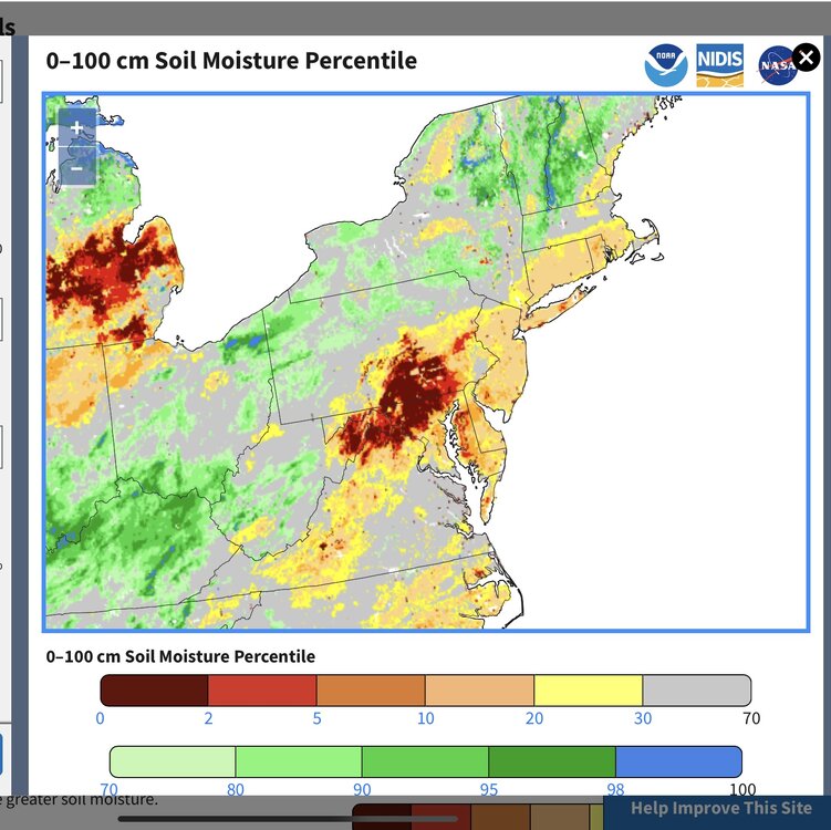
It’s more pronounced to our SW as they are down more than 10 inches since last summer.

-
Red and silver maples in full flower, also elms, and long catkins on the aspen. Otherwise, it's stick season still. Another 0.21" overnight, will report multi-day total of 1.10" for 25-27 after 2 days at Pittston Farm (where there were still patches of snow in the woods, not unusual for late April).
-
40F attm. Had to close windows during the night. Upcoming week looks splendid
-
Finished with 0.66”. If we could do that every 3-4 days through summer that would be great.
-
New Haven's like a month ahead of that. From my dash cam on Friday.

-
Wind whistling through those AC units you installed yesterday?

-
What a beautiful crisp morning!
-
Today definitely sucks . Thankfully it’s in and out quicker than that’s what she said and back to summer tomorrow.
-
He’s been here since last fall but his hands weren’t wrapped tightly around necks .. they’re starting to get stronger and squeezing harder as we gets his webb’s under him
-
Despite the warm, moist air surging north into Iowa, most models show little, if any, storm activity around here. Are we capped or something?
-
I still think it’s too early to be discussing any lasting shift in the Pacific. Since the ridge east of Japan and south of the Aleutians returned right after the winter mismatch ended related to what happened in the tropics last October. Remember, the west Pacific has been having more influence than whether the PDO has been in a positive or negative phase. As the 2nd EOF of the PDO has really been more significant in recent years than the old canonical understanding we used to use.
-
We’ll get some hopefully but he may be settling in. Can feel those webbed hands wrapped around me.
- Today
-
cold enough to wear a winter coat hat hoodie and gloves if i go out early hmm..
-
Yes especially around 4pm it was very strong.
-
Here come the wind gusts over 35 mph again to dry things out after the rain. https://mesonet.agron.iastate.edu/plotting/auto/?_wait=no&q=140&network=NY_ASOS&station=ISP&syear=1900&sday=0101&eday=0426&varname=avg_wind_gust&w=none&thres=1&year=2025&_r=t&dpi=100&_fmt=png Kennedy Intl PTCLDY 50 33 52 NW26G35


-
Doesn’t look like much
-
Well waddaya know.... ...WIND ADVISORY REMAINS IN EFFECT UNTIL 5 PM EDT THIS AFTERNOON... * WHAT...Northwest winds 15 to 25 mph with gusts up to 50 mph expected. * WHERE...Schuylkill and Sullivan Counties. * WHEN...Until 5 PM EDT this afternoon.
-
.73 here and low of 45F; will take it but will be wind dried quickly today.
-
Heat is back on. Did not know the winds would howl like this.
-
i was lying in bed listening to cousin brucie weekend rock and roll party which i do every saturday night 6-10 pm great hearing song of yesteryear i must have fallen asleep and missed any thunderstorms...
-
Cold again at 12:30 am 48F and wind chilly