All Activity
- Past hour
-
A GFS blend with the globals may be more likely...not buying the May 2005 redux.
-
Gorgeous. 75 this afternoon right down to the beaches.
-
Ah darn it...okay thanks.
-
I'm done, lol Ain't no way this is random luck repeating all these times. Something in the atmosphere changed or some quirk this year has made some weird uh...block? I'm not satisfied with no explanation for this
-
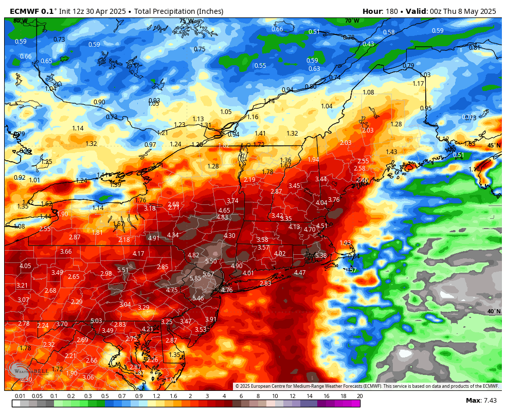
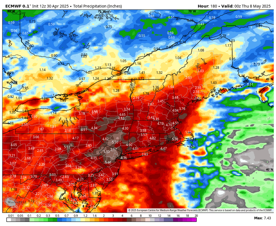
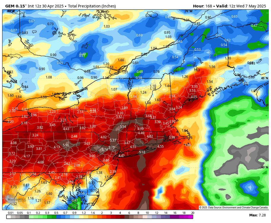
Monitoring for 5-7 Day drought buster Fri May 2-Fri May May 9... no thread from myself as yet but if it looks more likely that there will be 20% areal coverage 5+ in NYC subforum (Poconos-Catskills , to the Ct River and north of I-195, would then thread.
-
Holy shit
-
ukie
.thumb.png.2e422a1fa547c7530702fc470db0a7b1.png)
-
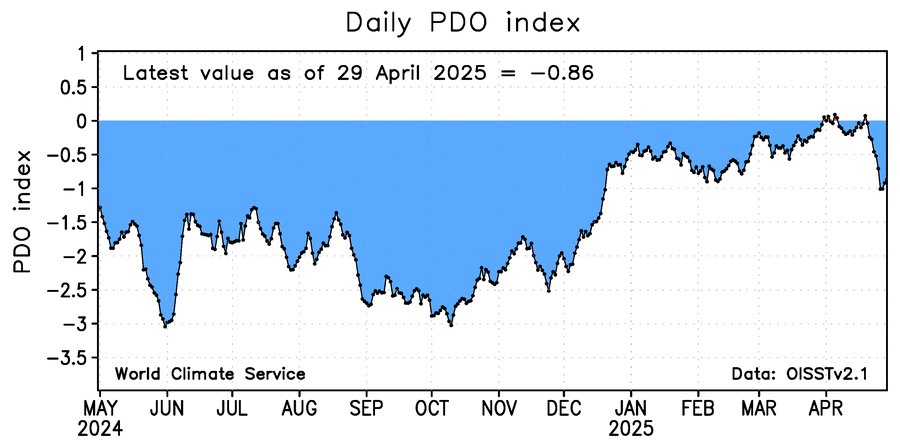
The image below of daily WCS PDO shows it has recently fallen and is at -0.86 as of yesterday. The corresponding NOAA PDO is likely ~~-1.75.
-
Tossing the GFS... looks pretty wet going forward on the others.
-
The usual area of lighter precip NW of I95 is present on the 12z GFS. Eastern VA jackpot.
-
Ukie gone wild next week
-
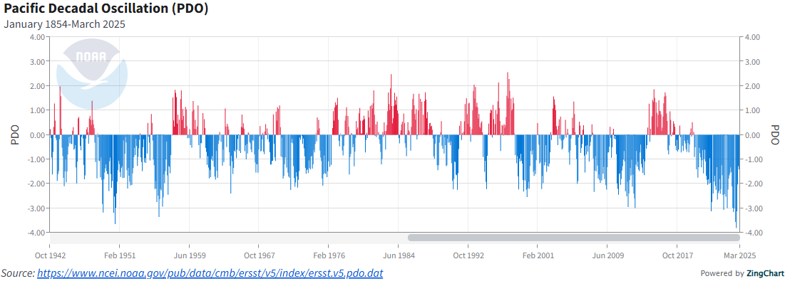
Despite Chris’ good thoughts and sources, I’m with you and @40/70 Benchmarkand still say 2014-6 was nearly a carbon copy of the late 1950s, a couple of year long +PDO period during a couple year long El Niño with a strong to very strong El Niño peak in the middle of a -PDO regime. This graph you posted says it all. The late 1980s was fairly similar but the opposite situation.
-
Amazing visibility today and perfect spring weather. Rare to get such such deep blue sky’s during the warm season.
-
Looks like east of ORH to BDL will salvage a chunk of Saturday. Especially ern mass. Winning.
-
1 to 2 looks good around SNE
-
Speaking of which...where is the PDO right now?
-
Maaaan I hope it ain't gonna be just on the same ol' area s/e...other regions need it a little more!
- Today
-
another nice month on tap.
- 1 reply
-
- 1
-

-
I look at the tropical Atlantic SST/OHC as just one of several important factors. It is, after all, a measure of the level of potential energy that can be tapped depending on other important factors. After all, this was the main reason 2023 was forecasted to be so active despite a strong El Niño. But even so, it won’t have much impact til at least July, which is still over 2 months away. And the peak of Sept is still 4 months away. SST/OHC may change a lot before then. Be that as it may, the fact that it is currently much cooler than last year is notable and this it will be interesting to follow going forward. It may warm up a lot as Barry suggests per the model prog. But even if so, will it reach the last 2 years’ levels? Regardless, two other regions (Gulf and Caribbean) are almost always quite warm throughout the season and thus their SST/OHC isn’t as crucial.
-
In particular, the GEFS made a huge move towards the other guidance.
-

2025-2026 ENSO
brooklynwx99 replied to 40/70 Benchmark's topic in Weather Forecasting and Discussion
I don't think there's any legitimate way that the 2013-15 +PDO could be viewed as a "three year cycle" or whatever. there have been numerous instances of +PDO in -PDO cycles and vice versa since the 40s. it's nothing new. you can see the same thing in the late 50s, late 80s, and the mid-2000s. IMO it's just authors trying to rationalize typical variance as a broader consequence of climate change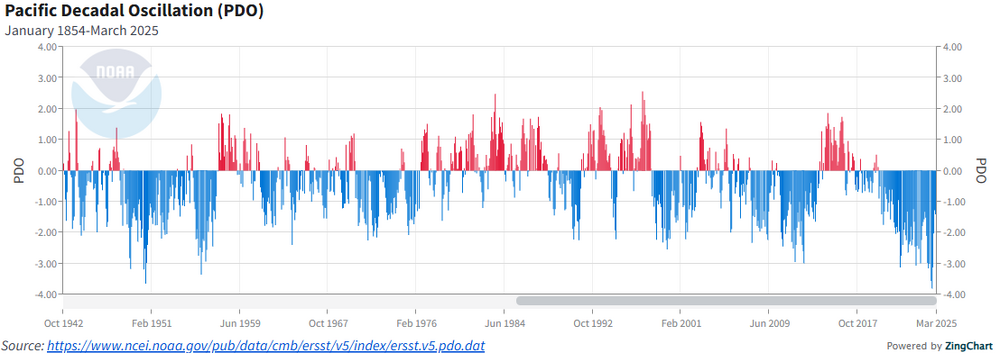
-

Central PA Spring 2025
Mount Joy Snowman replied to canderson's topic in Upstate New York/Pennsylvania
April looks to end up nestled in between 2021 and 1959 for 18th warmest all-time. -
It would be 40 degree drizzle for 2 weeks with that setup lol. Winter doesn't have the juice. I like seeing the GFS start cave.
-

Spring 2025 Medium/Long Range Discussion
Spartman replied to Chicago Storm's topic in Lakes/Ohio Valley
12z GFS caving to the recent Euro runs regarding the Omega Block next week 12z Euro has the Omega Block through a good portion of next week followed by another low trying to cut off near Mother's Day weekend, meaning no sustained warmth for at least the 1st half of the month -
If only that happened in the winter....


.png.fb6b39827c6934844ee41d3cff7574e6.png)