All Activity
- Past hour
-
Summer Spring Fall Winter Fall temps and humidity are generally better, but I will elevate spring for the sun angle and the fact that we’re heading toward warmer times versus 5 months of darkness.
-
 Lakifaj288 joined the community
 -
Around 5/5-6 timeframe the models build in an upper low near and NE of us, which we all know means nasty onshore/backdoor conditions. Hope it's wrong. Probably won't bring much rain either which we're starting to need and have to build up in the groundwater before summer.
-
Winter used to be the best. But winter is slowly slipping away. Can't fight it anymore.
-
Hey guys, Hope everyone's doing good. Do you guys know or can speculate what's happening in Spain and Portugal with the power outages?
-
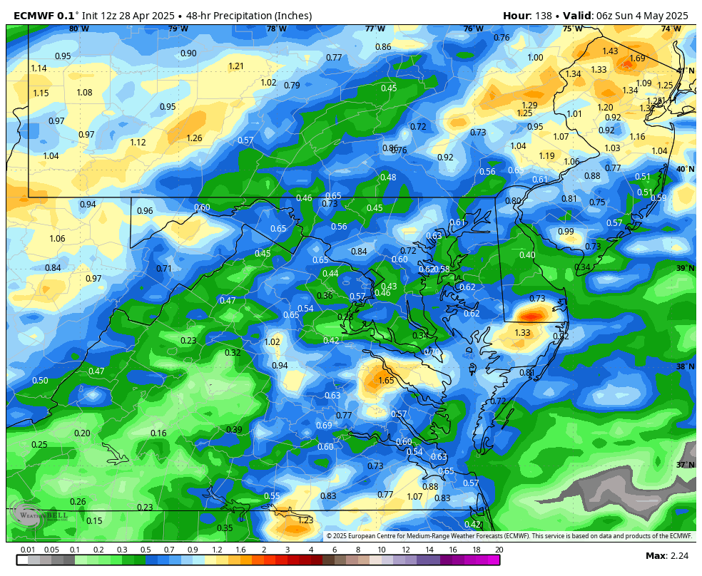
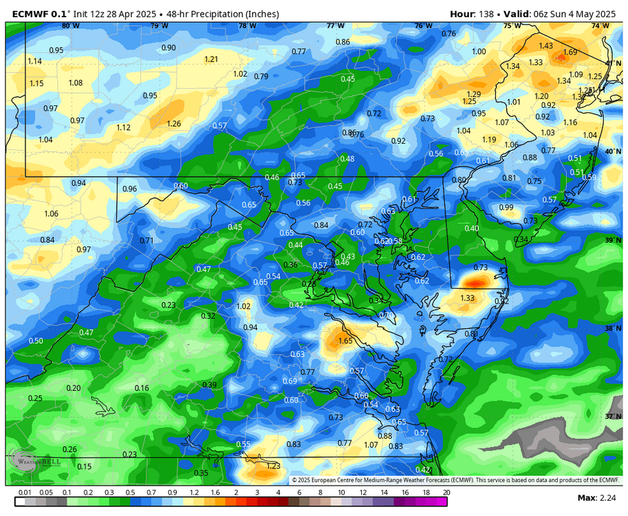
WB 12Z EURO.... wetter this run for the weekend.
-
We desperately need a head-scratch emoji. Scientific disciplines sometimes do adopt a word, the use of which is internally defined to the parlance of the scientific dialogue - I'm not sure I've personally ever encountered secular in any context of weather-related science, though - unless ( LOL ) it's how we feel around here when a BD sends summer to NYC while we're stuck in the 40s ... because we're definitely engaged in a NON-secular relationship with the weather when that happens.... secular /sĕk′yə-lər/ adjective Worldly rather than spiritual. "the secular affairs of the parish." Not relating to religion or to a religious body; nonreligious. "secular music." Not bound by the full monastic rule of a religious order. Used of clergy.
-
looks like a non-event around here. a marginal is questionable enough as it is, let alone an enhanced into portions of the CWA.
-
winter is by far the best.. Winter, Fall, Summer, Spring
-
Were those other storms firing up off outflows from the main cell and then combining back into it? It was very odd
- Today
-
70/27 20% RH
-
76 degrees here with a dewpoint of 31 and not a cloud in the sky. Weather doesn't get any better than this. The soil here is very dry though. I'm going outside now to water the vegetable garden. I hope we get a decent amount of rain at the end of the week. I see the Euro now gives us most of our rain Saturday instead of Friday.
-
All set with 70° dews unless its a beach day. Almost as bad as the sickos wanting 48° and drizzle in May. Give me 83/65 though
-
Thankfully ... the models are bum pounding another Saturday just like everyone wants -
-
Be even nicer out when these temperatures become the dewpoints
-

2025-2026 ENSO
40/70 Benchmark replied to 40/70 Benchmark's topic in Weather Forecasting and Discussion
I think prefacing cycle with the term "multidecadal" clears up any confusion. I don't see any length of time specification here.... Dictionary Definitions from Oxford Languages · Learn more cy·cle /ˈsīkəl/ noun 1. a series of events that are regularly repeated in the same order. -
2025-2026 ENSO
40/70 Benchmark replied to 40/70 Benchmark's topic in Weather Forecasting and Discussion
The term "multidecadal cycle" is pretty common place in meteorolgical vernacular, but the term "secular" is not. -

2025-2026 ENSO
PhiEaglesfan712 replied to 40/70 Benchmark's topic in Weather Forecasting and Discussion
People are misusing the word cycle. It's meant to describe a short-term pattern. Like the 2014-16 +PDO period is a cycle. The word to describe a long term pattern is secular. Like the 1976-1998 +PDO pattern is a secular pattern. So, 2014-16 was a +PDO cycle in the secular -PDO pattern that started in 1998. Just like in the stock market, 2003-07 was a bull market cycle in the secular 2000s bear market. Or the 1987 stock market crash was a bear market cycle in the 1983-1999 secular bull market. -
70/32 Nice day
-
Absolutely gorgeous out! 75,cool breeze and not a cloud in sight.
-
I'm worried about another wildefire near Napa.
-
2025-2026 ENSO
40/70 Benchmark replied to 40/70 Benchmark's topic in Weather Forecasting and Discussion
Yes, this is what I was getting at when I said that there have aways been intracycle deviations from the longer term mean...that doesn't negate the longer term, multidecadal trend....it reverys back. You can see this in my annotation with the double maxima pattern in each decadal cycle. There is also a colder intelrude (late 1980's) immersed within the last warm phase, which was also triggered by ENSO. Just to be clear...I am not denying or doubting CC...its very real. I just don't view this PDO cycling as a manifestation of it, nor do I feel that CC has impacted it....yet. I am, however, open to that conclusion if we do not see predominately +PDO during the 2030's, save for perhaps a La Nina induced stretch of -PDO interspered. I do feel that CC is impacting the phases themselves in terms of the associated SST patterns, but that is a different discussion. -
Chris, I see what you’re saying regarding the rapid changes but: 1) Why are you calling it a record +PDO in 2015? It was solidly positive and much higher than surrounding years, but it was nowhere near a record: -2015 PDO: +0.9 But: -1997 +1.3 -1993 +1.0 -1986 +1.0 -1987 +1.1 -1983 +1.2 -1941 +2.3 -1940 +1.8 -1936 +1.9 -1931 +1.0 -1926 +1.8 -1905 +1.4 -1904 +1.2 -1902 +1.2 **Edit: almost all of these were during and/or immediately adjacent to El Niño 2) The period 3/2014-7/2016 was no doubt a solid +PDO period with it averaging +1.0 surrounded by solid negative years. However, that was during a predominant El Niño period including a record strong Nino. To me this looks similar to 6/1957-1/1959, which also averaged +1.0 PDO, was surrounded by solid negative years, and was during a predominant El Niño period. https://www.ncei.noaa.gov/pub/data/cmb/ersst/v5/index/ersst.v5.pdo.dat @40/70 Benchmark
-
Outside a few roughish days this month, there have been some absolute banner days this April. Today is no exception. It’s absolutely immaculate out. I woke up from night shift sleep to enjoy this. 72° in Edgewater
-
Epic weather warnings need to be posted. I'm in the middle of a parking lot experiencing extremely beautiful weather. The breeze is in the extreme beautiful range gusting to gorgeous level. The sky is severe clear blue. The temperature just hit the perfect threshold of 72 degrees. Warnings need to be posted so people can escape office buildings and get into parks. I'm safe from missing the perfect conditions here at Bacon Ridge.
-
Watch issued: SEL0 URGENT - IMMEDIATE BROADCAST REQUESTED Tornado Watch Number 180 NWS Storm Prediction Center Norman OK 1230 PM CDT Mon Apr 28 2025 The NWS Storm Prediction Center has issued a * Tornado Watch for portions of Northwest Iowa Southwest Minnesota Extreme Southeast South Dakota * Effective this Monday afternoon and evening from 1230 PM until 800 PM CDT. * Primary threats include... A few tornadoes likely with a couple intense tornadoes possible Widespread large hail and scattered very large hail events to 3 inches in diameter likely Scattered damaging winds likely with isolated significant gusts to 80 mph possible SUMMARY...Isolated to scattered thunderstorms developing along a surface front will develop east/northeast through the afternoon. These storms will have the potential to produce large to very large hail, damaging wind gusts, and a few tornadoes. The tornado watch area is approximately along and 40 statute miles east and west of a line from 85 miles north of Redwood Falls MN to 30 miles west of Storm Lake IA. For a complete depiction of the watch see the associated watch outline update (WOUS64 KWNS WOU0). PRECAUTIONARY/PREPAREDNESS ACTIONS... REMEMBER...A Tornado Watch means conditions are favorable for tornadoes and severe thunderstorms in and close to the watch area. Persons in these areas should be on the lookout for threatening weather conditions and listen for later statements and possible warnings. && AVIATION...Tornadoes and a few severe thunderstorms with hail surface and aloft to 3 inches. Extreme turbulence and surface wind gusts to 70 knots. A few cumulonimbi with maximum tops to 500. Mean storm motion vector 24035. ...Leitman